Bellin, Jacques Nicolas, 1703-1772, creator France, Depot des cartes et plans de la marine
Published / Created:
1763
Call Number:
2003 Folio 85
Image Count:
1
Alternative Title:
Carte d'une partie de l'isle de Terre Neuve et les isles de St. Pierre et Miquelon [scale ca. 1:666,666]
Description:
BEIN 2003 Folio 85: No. 12 of 45 maps bound together with binder's spine title: Atlas of America; ms. table of contents. Bookplate: Robinson. Bookplate of Paul Mellon., Hand colored., par le S. Bellin ingenieur de la marine et du Depost M.DCC.LXIII., and Scale [ca. 1:15,400].
Publisher:
DeÌpost des cartes et plans de la marine
Subject (Geographic):
Newfoundland and Labrador -- Maps -- Early works to 1800 and Saint Pierre and Miquelon -- Maps -- Early works to 1800
Bellin, Jacques Nicolas, 1703-1772, creator France, Depot des cartes et plans de la marine Rameau, P.
Published / Created:
1763
Call Number:
2003 Folio 85
Image Count:
1
Description:
BEIN 2003 Folio 85: No. 40 of 45 maps bound together with binder's spine title: Atlas of America; ms. table of contents. Bookplate: Robinson. Bookplate of Paul Mellon., dressee au Depost des cartes et plans de la marine ; pour le service des vaisseaux du roy ; par ordre de M. le Duc de Choiseul, ministre de la guerre et de la marine ; par le Sr. Bellin, ingenieur de la marine., Hand colored., Insets: Plan du port du Carenage; Plan du cul de sac des Roseaux [with inset: Plan du cul de sac des Roseaux, reduit sur l'echelle du port du Carenage pour comparer leur grandeur]; Mouillages du Grand Islet et du Choc., P.A. Rameau fecit. 1763., Relief shown pictorially., and Scale [ca. 1:115,000].
Bellin, Jacques Nicolas, 1703-1772, creator France, DeÌpot des cartes et plans de la marine
Published / Created:
1760
Call Number:
2003 Folio 85
Image Count:
1
Description:
BEIN 2003 Folio 85: No. 41 of 45 maps bound together with binder's spine title: Atlas of America; ms. table of contents. Bookplate: Robinson. Bookplate of Paul Mellon., dressee au Depost des cartes et plans de la marine ; pour le service des vaisseaux du roy ; par ordre de M. Berryer, ministre et secretaire d'Etat aiant le Departemente de marine ; par le S. Bellin, ingenieur de la marine, du Depost des plans &c., Hand colored., Relief shown pictorially., and Scale [ca. 1:62,000].
Bellin, Jacques Nicolas, 1703-1772, creator Croisey, P. France, Depot des cartes et plans de la marine
Published / Created:
1763
Call Number:
2003 Folio 85
Image Count:
1
Description:
BEIN 2003 Folio 85: No. 45 of 45 maps bound together with binder's spine title: Atlas of America; ms. table of contents. Bookplate: Robinson. Bookplate of Paul Mellon., Croisey sculpsit., dressee au Depost des cartes et plans de la marine ; pour le service des vaisseaux du roy ; par ordre de M. le Duc de Choiseul, ministre de la guerre at de la marine ; par le S. Bellin., Hand colored., Inset: Isle de Cayenne dans la Guyane., Relief shown pictorially. Depths shown by soundings., and Scale [ca. 1:1,000,000].
Publisher:
Depost des cartes et plans de la marine
Subject (Geographic):
Cayenne (French Guiana) -- Maps -- Early works to 1800 and French Guiana -- Maps -- Early works to 1800
Subject (Topic):
Nautical charts -- French Guiana -- Early works to 1800
Bellin, Jacques Nicolas, 1703-1772, creator France, Depot des cartes et plans de la marine
Published / Created:
1791
Call Number:
2003 Folio 85
Image Count:
1
Description:
BEIN 2003 Folio 85: No. 6 of 45 maps bound together with binder's spine title: Atlas of America; ms. table of contents. Bookplate of Paul Mellon., Hand-colored., Includes insets Vue de terres du sud pour passer la traverse en remontant le fleuve and Partie du cours du fleuve de Saint Laurent depuis Quebec jusqu au cap aux Oyes, ca. 1:120,000., Par le S. Bellin ingenieur de la marine ... Dressee au Depost des cartes et plans de la marine. Pour le Service des vaisseaux du rou. Par ordre de M. Berryer, ministre et secretaire d'etat aiant le Departement de la marine., Relief shown pictorially and by hachures. Soundings shown in fathoms., and Scale ca. 1:415,000.
Publisher:
Depot de la Marine
Subject (Geographic):
Saint Lawrence River -- Maps -- Early works to 1800
Subject (Topic):
Nautical charts -- Saint Lawrence River -- Early works to 1800
Bellin, Jacques Nicolas, 1703-1772, creator Choiseul, Etienne-François, duc de, 1719-1785 France, DeÌpoÌ?t des cartes et plans de la marine
Published / Created:
1762?
Call Number:
2003 Folio 85
Image Count:
1
Description:
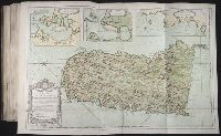
BEIN 2003 Folio 85: No. 30 of 45 maps bound together with binder's spine title: Atlas of America; ms. table of contents. Bookplate: Robinson. Bookplate of Paul Mellon., dressee au Depost des cartes et plans de la marine, pour le service des vaisseaux du roy ; par ordre de M. le duc de Choiseul, colonel general des suisses et grisons, ministre de la guerre et de la marine, 1762 par le S. Bellin, ingenieur de la marine., Hand colored., Includes index and insets of Le Fort du Maure, Le Fort de la Pointe, and Le Vieux Chateau., Relief shown by hachures. Soundings shown in feet., and Scale [ca. 1:12,500].
Publisher:
Depost des cartes et plans de la marine
Subject (Geographic):
Havana (Cuba) -- Buildings, structures, etc -- Maps -- Early works to 1800, Havana (Cuba) -- Maps -- Early works to 1800, and Havana Bay (Cuba) -- Maps -- Early works to 1800
Subject (Topic):
Fortification -- Cuba -- Havana -- Maps -- Early works to 1800 and Nautical charts -- Cuba -- Havana Bay -- Early works to 1800
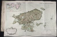
BEIN 2003 Folio 85: No. 35 of 45 maps bound together with binder's spine title: Atlas of America; ms. table of contents. Bookplate: Robinson. Bookplate of Paul Mellon., Hand colored., par le S. Bellin, ingenieur de la marine et du Depost des plans, Censeur royal de l'Academie et de la Societe royale de Londres ; tiree des cartes angloises, 1758., Relief shown pictorially., and Scale [ca. 1:92,500].
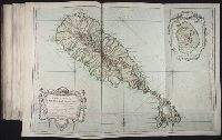
BEIN 2003 Folio 85: No. 34 of 45 maps bound together with binder's spine title: Atlas of America; ms. table of contents. Bookplate: Robinson. Bookplate of Paul Mellon., Hand colored., Inset: Isle de Nieves, situe a une lieue au sud de S. Christophe., par le S. Bellin, ingenieur de la Marine et du Depost des plans, Censeur royal de l'Academie et de la Societe royale de Londres, 1758., Relief shown pictorially., and Scale [ca. 1:58,334].
Publisher:
DeÌpost des cartes, plans et journaux de la marine
Subject (Geographic):
Saint Kitts and Nevis -- Maps -- Early works to 1800
Bellin, Jacques Nicolas, 1703-1772, creator France, Depot des cartes et plans de la marine
Published / Created:
1758
Call Number:
2003 Folio 85
Image Count:
1
Description:
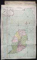
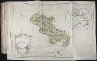
BEIN 2003 Folio 85: No. 38 of 45 maps bound together with binder's spine title: Atlas of America; ms. table of contents. Bookplate: Robinson. Bookplate of Paul Mellon., dressee au Depost des cartes plans et journaux de la marine pour le service des vaisseaux du roy. Par ordre de M. de Moras, ministre et secretaire d'Etat aiant le Department de la marine. Par M. Bellin, ingenieur de la marine et du Depost des plans, Censeur royal, de l'Academie de marine, et de la Societe royale de Londres. M.DCC.LVIII., Hand colored., Inset: Plan du Cul de Sac Royal de la Martinique., Prime meridian: Paris., Relief shown pictorially. Depths shown by soundings., and Scale [ca. 1:350,000].
Publisher:
Depot des cartes et plans de la marine
Subject (Geographic):
Fort-de-France Bay (Martinique) -- Maps -- Early works to 1800 and Martinique -- Maps -- Early works to 1800
Bellin, Jacques Nicolas, 1703-1772, creator France, Depot des cartes et plans de la marine
Published / Created:
1760
Call Number:
2003 Folio 85
Image Count:
1
Description:
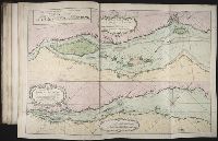
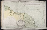
BEIN 2003 Folio 85: No. 44 of 45 maps bound together with binder's spine title: Atlas of America; ms. table of contents. Bookplate: Robinson. Bookplate of Paul Mellon., dressee au Depost des cartes et plans de la marine ; pour le service des vaisseaux du roy ; par ordre de M. Berryer, ministre et secretaire d'Etat aiant le Departemente de marine ; par le S. Bellin., Hand colored., Insets: Vue des terres entre le Cap d'Orange et Cayenne; Vue de la coste aux environs de Cayenne., Relief shown pictorially. Depths shown by soundings., and Scale [ca. 1:650,000].
Publisher:
Depost des cartes et plans de la marine
Subject (Geographic):
Cayenne (French Guiana) -- Maps -- Early works to 1800 and French Guiana -- Maps -- Early works to 1800
Subject (Topic):
Nautical charts -- French Guiana -- Early works to 1800