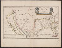
"Avec privilege du roy, pour vignt ans.", Hand col. Mounted on linen. Sheet measures 46 x 59.6 cm. Cross Collection no. 226., and Shows California as an island.
Appeared in Sanson's Cartes générales de toutes les parties du monde., Ms. note on verso: 104. Sheet measures 45.1 x 59.6 cm., Prime meridian: Ferro., Relief shown pictorially., and Watermark.
Publisher:
Chez Pierre Mariette ...,
Subject (Geographic):
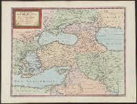
Mediterranean Region--Maps--Early works to 1800 and Middle East--Maps--Early works to 1800
Subject (Name):
Mariette, Pierre, 1634-1716, Sanson, Nicolas, 1600-1667. Cartes générales de toutes les parties du monde, and Somer, J., engraver
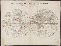
Description generale du globe terrestre et aquatique en deux-plans-hemispheres and Mappe-monde geo-hydrographique
Description:
"Presenté a Monseigneur le Dauphin, par son tres-humble, tres-obeissant et tres-fidele feruiteur, Hubert Jaillot"--Cartouche., Cross collection no. 27., Imperfect: chipped along edges, with no loss of text. Plate IV, state 3 (cf. Shirley 462)., Includes surrounding decorative illustrations., One of a number of printings from a map first drawn by Nicolas Sanson in 1674; later issued in Jaillot's Atlas nouveau [1681 and onwards]., and Relief shown pictorially.
Publisher:
Hubert Jaillot,
Subject (Name):
Jaillot, Alexis Hubert, 1632?-1712 and Jaillot, Alexis Hubert, 1632?-1712. Atlas nouveau
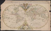
Description generale du globe terrestre et aquatique en deux-plans-hemispheres and Mappe-monde geo-hydrographique
Description:
Imperfect: Torn along center fold, with some loss of text. Hand col. Sheet measures 64 x 100 cm. Ms. stamp on verso: Horace Brown 1900S., Includes surrounding decorative illustrations., and One of a number of printings from a map first drawn by Nicola
Part of the circle of Austria in which are the Dukedomes of Stiria, and Carinthia, of Carniola, in which are comprehended the countys of Chilley, and of Gorice, Windis-Marke, or Marquisat of Windes, described by Sanson, corrected and amended by William Berry
Description:
Bar scales in Italian miles, common leagues of Germany, great leagues of Germany, leagues of Hungary, common leagues of France, and great leagues of France or one hours travelling., Dedicated to The most high mighty and most excellent prince ----------------- prince of England, Scotland, France and Ireland, and Duke of Cornwall by William Berry, Ferro meridian., No. 28 of 69 maps bound together in composite atlas., Relief shown pictorially., and Scale [ca. 1:660 000].
Publisher:
Sold by William Berry at the sign of the Globe between Charing-Cross, and White-Hall
Part of the circle of Austria viz. the Archdukedom of Austria divided into the higher above the river Ens, and the lower below the Ens ... described by Sanson, corrected and amended by William Berry
Description:
Bar scales in Italian miles, common leagues of Germany, great leagues of Germany, leagues of Hungary, common leagues of France, and leagues of one hours travelling., Dedicated To the most serene and most sacred majesty James II ... by William Berry., Ferro meridian., No. 27 of 69 maps bound together in composite atlas., Relief shown pictorially., and Scale [ca. 1:510 000].
Publisher:
Sold by William Berry at the sign of the Globe between Charing-Cross, and White-Hall
Plan de la ville de Vienne et ses environs par le Sr. Sanson
Description:
"Avec privilege du roy"., Appears in Jaillot's Atlas françois; cf. Pastoure, Bar scales given in "lieue commune d'Allemagne," "grande lieue d'Allemagne," and "lieue d'une heure de chemin"., Relief shown pictorially., Sheet measures 62.8 x 97.5 cm., and Watermark.
Publisher:
Chez H. Iaillot joignant les grands Augustins aux deux globes,
Territories of the crown of Poland subdivided into their severall palatinates ... described by Sanson, corrected and amended by William Berry
Description:
Bar scales in Italian miles, common leagues of France, common leagues of Germany, leagues of Hungary, common leagues of Poland, and great leagues of Poland., Dedicated To the most serene and most sacred majesty of Charles II ... by William Berry., Ferro meridian., No. 39 of 69 maps bound together in composite atlas., Relief shown pictorially., and Scale [ca. 1:2 100 000].
Publisher:
Sold by William Berry at the sign of the Globe between Charing-Cross and White-Hall
Catalonia under which name are comprehended the principality of Catalonia and the counties of Rossillion and of Cerdagne ... described by Sanson, corrected & amended by William Berry
Description:
Bar scales given in Italian miles, common leagues of France, common leagues of Spain, common leagues of Germany, and leagues of on houes travelling., Dedicated To the most serene and most sacred majesty of Charles II ... by William Berry., Includes coat of arms and decorative cartouche containing dedication., No. 11 of 69 maps bound together in composite atlas., Prime meridian: Ferro., Relief shown pictorially., and Scale [ca. 1:640 000].
Publisher:
Sold by William Berry at the signe of the Globe between Chering Cross and White Hall