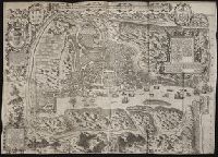
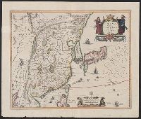
John Huighen van Linschoten, his Discours of Voyages into ye Easte & West Indies
Image Count:
1
Description:
Bound in following p. 52., Map has numerous repairs on verso with tape., Map has some small tears along fold lines, most notably in the center., and Scale not given.
Subject (Geographic):
Goa (India : State) --Maps and Velha Goa (India)
Subject (Topic):
Voyages and travels --Early works to 1800
Collection Created:
[London] : Printed at London by [John Windet for] Iohn Wolfe, printer to ye Honorable Cittie of London, [1598]
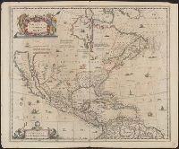
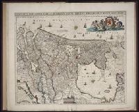
Covers North America, Cent, Dutch text on verso, with signature "Bb.", Relief shown pictorially., and State 2, first issued in 1641, according to Burden; matches description of Dutch text versions appearing in Nieuwen atlas editions 1645, '47, '52, '53, and '58.
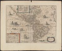
Appears in various eds. of Jansson's Nieuwen atlas., Dutch text on verso., Includes ill. of ships and sea monsters, and insets showing "Polus Arcticus" region and "Terra Australis incognita.", Relief shown pictorially., and Sheet measures 50.1 x 60.9 cm.
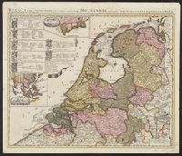
"Cum privil.", Appears in Schenk's Atlas contractus ... [Amsterdam : Peter Schenk, ca. 1700]., Imperfect: Mutilated, with some loss of text. Sheet measures 53.5 x 62 cm. Verso: "19" (?) in ink ms., Insets: Batavorum colon, and Relief shown pictorially.
Publisher:
Peter Schenk?
Subject (Geographic):
East Indies--Maps--Early works to 1800, Netherlands--Maps--Early works to 1800, and New Netherland--Maps--Early works to 1800
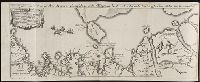
Descriptio ac delineatio geographica detectionis freti, sive, transitus ad occasum supra terras
Image Count:
1
Alternative Title:
Caerte van’t noorderste Russen, Samojeden, ende Tingoesen landt
Description:
Bound in after p. [30]., Description of Siberia by Isaac Abrahamszoon Massa., Map cut and folded irregularly., Map has multiple small ink stains on verso at the top., Printed on recto in lower right corner: D3., and Scale not given.
Subject (Geographic):
Barents Sea --Maps --Early works to 1800
Subject (Name):
Massa, Isaac, 1587-1635
Collection Created:
Amsterodami Ex officina Hesse lij Gerardi. Anno 1613
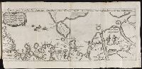
"Cum privil.", "I. Bormeester, eccu.", Bar scales given in "Gemene Duÿtsche Mÿlen 15 in een Graedt" and "Uren gaens de 4 maken 3 Mÿlen"., BEIN 1973 Folio 18: Backed with paper. Ms. no. "41" in upper-right corner. Sheet measures 53.6 x 62.7 cm. No. 40 of 87 maps bound together., Inset: De resterende Eÿlanden van Hollant alhier bÿgevoecht., North oriented to the upper-right., Prime meridian: Ferro., Relief shown pictorially., and Title in Latin; place names in Dutch.