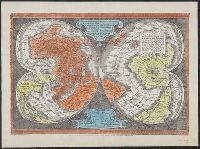
"Ne que ad nos Fram orbis ... Cappadocie 7.", "Quam hic vides orbis imagine lector cadide ... Vale 1538", Cordiform map of the world, 1538, Joanni Drosio suo Gerardus Rupelmudan deducabat., Map of the world, 1538, Orbis imago., and World map on double cordiform pro
Description:
Also known as World map on double cordiform projection and Orbis imago., Cross collection no. 4., Facsimile of Gerhard Mercator's first world map, published in Louvain, 1538., Relief shown pictorially., and Title from another facsimile published by the New York Public Library.
Publisher:
Julius Bien & Co., photo-lith,
Subject (Name):
Brevoort, James Carson, 1818-1887 and Julius Bien & Co
Subject (Topic):
Early maps--Facsimiles and World maps--Early works to 1800--Facsimiles
"Photolithographed copy of Gerard Mercator's Mapamundi of 1538 from an original engraving in the library of the American Geographical Society.", Relief shown pictorially., and Title devised by cataloger.
Publisher:
Julius Bien & Co., photo-lith,
Subject (Geographic):
World--Maps--Early works to 1800
Subject (Name):
American Geographical Society of New York and Julius Bien & Co
Subject (Topic):
Early maps, Early maps--Facsimiles, World maps, and World maps--Early works to 1800
Cross Collection no. 60., From Janssonius's Niewen atlas ... Amstelodami : Apud Ioannem Ianssonium, 1652., Hand col. Mounted on linen., Includes marginal ill., Relief shown pictorially., Title supplied by cataloger., and Variant of Hondius' Polus Antarcticus, 1638.
Publisher:
J. Jansson,
Subject (Geographic):
Antarctica--Maps--Early works to 1800 and Southern Hemisphere--Maps--Early works to 1800
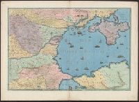
Contains five compass roses., Decoration: city views with banners, figures holding armorial shields, animals, and Jesus Christ on the cross flanked by the Virgin Mary and Mary Magdalene., Includes degrees of latitude along left edge: 18°N to 63°N., Includes two North Atlantic islands "Frislandia" and "Stilanda" in upper left corner and inset map of the world in the lower center., Pen-and-ink in black, red, blue and green., Portolan chart with seaport names given for all coastlines., and Title devised by cataloger; last two numerals of date have been altered.
Subject (Geographic):
Baltic Sea--Maps--Early works to 1800, Mediterranean Sea--Maps--Early works to 1800, and North Atlantic Ocean--Maps--Early works to 1800