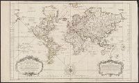
At bottom of the title cartouche: "Par le S.r Bellin, Ingenieur de la Marine and New Guinea shown joined to New Holland; Dampier's Strait marked. Bellin traces the 'hypothetical' coast of New Holland which was object of speculation before Cook's discoveries.
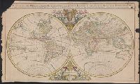
Description generale du globe terrestre et aquatique en deux-plans-hemispheres and Mappe-monde geo-hydrographique
Description:
"Presenté a Monseigneur le Dauphin, par son tres-humble, tres-obeissant et tres-fidele feruiteur, Hubert Jaillot"--Cartouche., Cross collection no. 27., Imperfect: chipped along edges, with no loss of text. Plate IV, state 3 (cf. Shirley 462)., Includes surrounding decorative illustrations., One of a number of printings from a map first drawn by Nicolas Sanson in 1674; later issued in Jaillot's Atlas nouveau [1681 and onwards]., and Relief shown pictorially.
Publisher:
Hubert Jaillot,
Subject (Name):
Jaillot, Alexis Hubert, 1632?-1712 and Jaillot, Alexis Hubert, 1632?-1712. Atlas nouveau
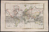
From Bonne's Atlas de toutes les parties connues du globe terrestre ... [Paris : J.L. Pellet, 1780?]., Hand col. Sheet measures 26 x 39 cm. Verso: "Projection de Mercator" in ink ms. Lada-Mocarski Collection., Meridians: Ferro, Paris., and Top left, in margin: "
Publisher:
J.L. Pellet,
Subject (Name):
Bonne, Rigobert, 1727-1794. Atlas de toutes les parties connues du globe terrestre .. and Pellet, J.-L. (Jean-Léonard), publisher
Subject (Topic):
Cartographers--France--18th century and World maps--Early works to 1800