Skip to search
Skip to main content
Skip to first result
Search
You Searched For
Resource Type
Maps, Atlases & Globes
Subject (Topic)
World maps--Early works to 1800
Publication Place
Paris :
New Search
Search Results
Creator:
Published / Created:
1761
Call Number:
11 1761
Container / Volume:
BRBL_00681
Image Count:
1
Resource Type:
Maps, Atlases & Globes
Description:
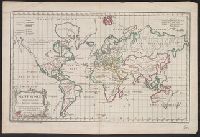
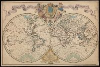
"Gravé par E. Dussy.", Cross collection no. 44., Map of the world, showing imaginary coastline of Australia joining Van Diemen's Land to d'Esprit., and Title in decorative frame; colour-coded according to major world religions.
Publisher:
Chez l'Auteur, Quai de l'Horloge pres le Pont neuf,
Subject (Name):
Dussy, E., fl. 1754-1778
Subject (Topic):
Religions--Maps--Early works to 1800 and World maps--Early works to 1800
Found in:
Beinecke Rare Book and Manuscript Library > Mappe monde [cartographic material] : suivant la projection des cartes reduites / par le s. Robert de Vaugondy.
Creator:
Published / Created:
1720
Call Number:
11 1720
Image Count:
1
Resource Type:
Maps, Atlases & Globes
Description:
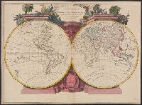
Cross collection no. 30., Includes ill., Relief shown pictorially., Shows nautical exploration routes., and Watermark.
Publisher:
Chez Guillaume Delisle, premier geographe du roy, de l'Academie royale des sciences, sur le quay de l'horloge, avec privilege,
Subject (Topic):
Nautical charts., Navigation, and World maps--Early works to 1800
Found in:
Beinecke Rare Book and Manuscript Library > Mappemonde a l'usage du roy [cartographic material] / par Guillaume Delisle, premier geographe de S.M.
Branch:v1.61.6 ,Deployed:2024-06-12T09:55:31-04:00