Skip to search
Skip to main content
Skip to first result
Search
You Searched For
Genre
Maps
Creator
Warren, Gouverneur Kemble, 1830-1882
Subject (Name)
Bien, Julius, 1826-1909
New Search
Search Results
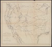
Creator:
Published / Created:
1855
Call Number:
80gme 1855A
Container / Volume:
BRBL_00538
Image Count:
1
Resource Type:
Maps, Atlases & Globes
Description:
"This map is a hurried compilation of all the authentic surveys and is designed to exhibit the relations of the different routes to each other.", Appears in 33d Cong., 1st Sess., House Ex. Doc. 129, Serial 736., and Relief shown by hachures and spot heights.
Publisher:
Lith. of J. Bien,
Subject (Name):
Bien, Julius, 1826-1909
Subject (Topic):
Pacific railroads--Maps and Railroads--West (U.S.)--Maps
Found in:
Beinecke Rare Book and Manuscript Library > Map of routes for a Pacific railroad : compiled to accompany the report of Hon. Jefferson Davis, Sec. of War / G.K. Warren.
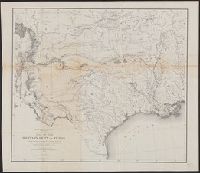
Creator:
Published / Created:
1859
Call Number:
796 1859A
Container / Volume:
BRBL_00525
Image Count:
1
Resource Type:
Maps, Atlases & Globes
Alternative Title:
Map of the territory of the United States from the Mississippi River to the Pacific Ocean.
Description:
Relief shown by hachures. and Shows Indian tribal locations, military posts, and routes and dates of expeditions and surveys.
Publisher:
Office Expl.ns and Surveys, War Dep't,
Subject (Geographic):
Texas--Maps
Subject (Name):
Bien, Julius, 1826-1909, Humphreys, A. A. (Andrew Atkinson), 1810-1883, and United States. Office of Explorations and Surveys
Subject (Topic):
Military bases--Texas--Maps
Found in:
Beinecke Rare Book and Manuscript Library > Map of the military dep't of Texas : being a section of the map of the territory of the U.S. from the Mississippi River to the Pacific Ocean / compiled from all the reliable data by Lt. G.K. Warren, T.E., under the direction of Capt. A.A. Humphreys, T.E.
Branch:v1.61.6 ,Deployed:2024-06-12T09:55:37-04:00