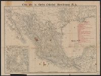
Indexed atlas of the world map of Mexico, Plano general de la ciudad de Mexico., and Rand, McNally & Co.'s indexed atlas of the world map of Mexico
Description:
"Cia. de la Guia Oficial Mexicana S.A.", Includes index to railroads and "Map of the Valley of Mexico, on enlarged scale" (scale [ca. 1:300,000])., On verso: Plano general de la ciudad de Mexico / formado de esprofeso p.a la C.a de la Guia Oficial Mexicana ; Luis G. Becerril. Scale 1:15,000. 1903., and Relief shown by hachures and spot heights.
Publisher:
Rand, McNally,
Subject (Geographic):
Mexico City (Mexico)--Maps and Mexico--Maps
Subject (Name):
Cia. de la Guia Oficial Mexicana S.A
Subject (Topic):
Railroads--Mexico--Maps and Streets--Mexico--Mexico City--Maps
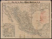
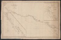
Insets: Harbour of Monterey / surveyed by the officers of the U.S.S. Dale ... 1843. Scale [ca. 1:30,500] -- The Harbour of San Francisco / surveyed by Captn. F.W. Beechey -- [Coast from Port Venderas to San Francisco]. Scale [ca. 1:5,650,000]. and Shows route of "Corvetas Descubierta y Atrevida en 1791."
Publisher:
E. & G.W. Blunt,
Subject (Name):
Beechey, Frederick William, 1796-1856. Harbour of San Francisco
Subject (Topic):
Harbors--California--Monterey--Maps, Naut, Nautical charts--California, Nautical charts--California--Monterey Bay, Nautical charts--California--San Francisco Bay Area, and Nautical charts--Central America
Includes insets of "Harbour of San Francisco, surveyed by Capt. F.W. Beechey" and the west coast from Port Venderas to San Francisco., Relief shown by hachures. Depths shown by soundings., and Shows route of "Corvetas Descubierta y Atrevida en 1791."
Publisher:
E. & G.W. Blunt,
Subject (Name):
Beechey, Frederick William, 1796-1856. Harbour of San Francisco
Subject (Topic):
Harbors--California--Monterey--Maps, Naut, Nautical charts--California, Nautical charts--California--Monterey Bay, Nautical charts--California--San Francisco Bay Area, and Nautical charts--Central America
The diaries describe an 1849 expedition by way of St. Joseph, Fort Kearney, Fort Laramie, South Pass, Sublette's Cut-off, Bear River, Cantonment Loring, Raft River, the Humboldt, Lassen's Route to Deer Creek, and Bruff's camp. They contain maps and sketches from the journey and notes on life in California. The journals were written from the diaries. The notebooks contain more sketches from the trip and of equipment. There are memoranda of supplies and equipment, routes, and remedies.
Subject (Geographic):
California --Description and travel, West (U.S.) --Description and travel, West (U.S.) --Maps, and West (U.S.) --Pictorial works
Subject (Name):
Bruff, Joseph Goldsborough, 1804-1889 and Washington City and California Mining Association
Subject (Topic):
Gold mines and mining --California --History --19th century --Personal narratives, Gold mines and mining --North America --History --19th century, Gold mines and mining --Sierra Nevada (Calif. and Nev.), Gold mines and mining --United States --History, and Gold mines and mining --West (U.S.) --History --19th century
Luisiana, aņo de 1798, sur d'oueste de la ciudad. and Plano de la ciudad de Nueva Orleans.
Description:
"Luisiana, año de 1798, sur d'oueste de la ciudad," in French, Spanish and English, dated Marzo, 16 de 1798, and signed: Carlos Trudeau., "Plano de la ciudad de Nueva Orleans" in French and Spanish, dated 6 de Agosto 1799, and signed at end: Carlos Trudeau., At foot of map, "Luisiana, año de 1798 ... ": Recorded in the Book No. 3, page 216, New Orleans, juin 3th 1808. Van Pradelles ..., Maps are hand colored. Old fold marks visible., and Two folding plans of New Orleans by Charles Trudeau; to accompany Thierry's Examen des droits des Etats Unis ... , Nouvelle-Orleans, De l'imprimerie de Thierry & Co., 1808.
Publisher:
s.n.,
Subject (Geographic):
New Orleans (La.)--Maps
Subject (Name):
Thierry, J. B. S. (Jean Baptiste Simon), d. 1815. Examen des droits des Etats-Unis et des pretentions de Mr. Edouard Livingston sur la batture en face du faubourg Ste. Marie. and Thierry, J. B. S.--(Jean Baptiste Simon),--d. 1815.--Examen des droits des Etats-Unis et des pretentions de Mr. Edouard Livingston sur la batture en face du faubourg Ste. Marie.