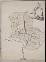
Карта большой Санктпетербургской дороге лежашей чрезъ Тверскую губернію / губернский землемеръ Андрей Петин.
Description:
Includes two insets, one showing the number of inhabitants in the 46 towns and villages along the road, the other the distances between various locations. and Mounted on silk. Manuscript annotation on map.
Subject (Geographic):
Tverskai︠a︡ oblastʹ (Russia)--Maps--Early works to 1800.
Bersenev, Ivan Mikhaĭlovich, -1789 Берсенев, Иван Михайлович, -1789
Published / Created:
[1785?]
Call Number:
BrSides Double Folio 2019 76
Image Count:
1
Resource Type:
Maps, Atlases & Globes
Alternative Title:
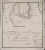
Карта реки Дниепра ивсего Лимана отъ Херсона до мыса А., Кинбурнскои берегъ / описи флота капитана второго ранга Берсенева 1785 года. Очаговскои берегъ наложенъ спрежднихъ картъ, глубина назначена въ футахъ.
Description:
Annotations on verso of map: "Liman de Dnjepr", "Liman[undeciphered] - 4, zabzan.[?] 3". Stained and repaired, lacking blank corner., Coordinates not present on maps and are approximated., and Relief shown by shadings. Depths shown by soundings.
Subject (Geographic):
Khersonsʹka oblastʹ (Ukraine)--Maps--Early works to 1800.
Stamp of the Preussische Staatsbibliothek, Berlin. On verso of map: Manuscript annotations and shelf mark: "Sec. XXIV., No.37". and Title devised by cataloger.
Subject (Geographic):
Khmelʹnyt︠s︡ʹka oblastʹ (Ukraine)--Maps--Early works to 1800. and Moldova--Maps--Early works to 1800.