Album containing 122 engravings by Stukeley, many in proof, assembled by the artist himself. Contents include 85 engravings from Itinerarium Curiosum and 23 from Stonehenge, a Temple Restor’d to the British Druids.
Description:
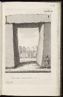
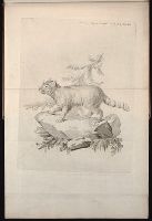
Plate numbered 104.
Subject (Geographic):
Great Britain --Antiquities --Early works to 1800 and Wiltshire (England) --Antiquities
Subject (Topic):
Megalithic monuments --England --Wiltshire and Stonehenge (England)--Early works to 1800
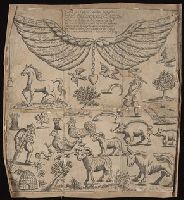
New England: the most remarqueable parts thus named by the high and mighty Prince Charles, nowe King of great Britaine [map] and Path-way to experience to erect a plantation.
Description:
Imperfect: damp-stained; added port. of Charles I., Map with portrait of Capt. Smith in corner: New England ... / observed and described by Captayn John Smith. 1614. Pendleton's Lithography, Boston. Drawn by J. Eddy. London, printed by Geor: Low., Signatures: A-F⁴., and Teaching resource: Professor John Mack Faragher, History 141: The American West.
Publisher:
Printed by I. Haviland, and are to be sold by R. Milbovrne,
Subject (Geographic):
Massachusetts--History--Colonial period, ca. 1600-1775, Massachusetts--Maps--Early works to 1800, New England--Description and travel, New England--History--Colonial period, ca. 1600-1775, and New England--Maps--Early works to 1800
"A catalogue of the names of the general authors, both ancient and modern, besides later voyagers, consulted to the carrying on of this first volume": 7th prelim. leaf., Imperfect: 2 maps (Tunis and Lovando St. Paulo) wanting., In this Beinecke copy, the 1st prelimin. leaf bears text "English atlas, tome the first" and the "Catalog" is on the 8th prelim. leaf., and Title in red and black; intials; head-pieces.
Publisher:
Printed by T. Johnson for the author,
Subject (Geographic):
Africa--Description and travel, Islands of the Atlantic, and Islands of the Indian Ocean
Subject (Name):
Boynton, Griffith--Autograph and ms notes and Hodgdon, Ernest F.--Stamp