Bumstead, Albert H. (Albert Hoit), 1875-1940 National Geographic Society (U.S.). Cartographic Division
Published / Created:
1918
Call Number:
11hc 1918C
Container / Volume:
BRBL_00010E
Image Count:
1
Resource Type:
Maps, Atlases & Globes
Alternative Title:
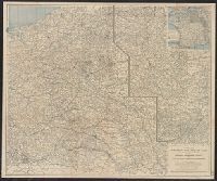
Index to the map of the Western Theatre of War.
Description:
Detached from: National Geographic, May 1918., Indexed by: Index to the map of the Western Theatre of War., and Inset: "Showing relation of the Western Theatre of War to the surrounding region and the connection of the two sections of the main map."
Publisher:
The Society,
Subject (Geographic):
Alsace (France)--Maps, Europe--Maps, and Lorraine (France)--Maps
Subject (Topic):
World War, 1914-1918--Belgium--Maps, World War, 1914-1918--France--Maps, and World War, 1914-1918--Maps
In lower right corner: "For continuation of "French Front" South, see Section No. 3.", Includes legend., Index on verso of map., and Inset: General war map.
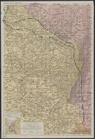
Edward Stanford Ltd. Stanford's war maps ; no. 18., Map of the battle front between the Somme and Soissons, and Stanford's war maps ; no. 18
Description:
Relief shown as gradient tints. and Shows: roads, railways, canals, woods, battle front.
Subject (Geographic):
France--Maps, Soissons (France)--Maps, and Somme (France)--Maps
Subject (Topic):
Chron.--1917, Somme, 1st Battle of the, France, 1916--Maps, Somme, 2nd Battle of the, France, 1918--Maps, World War, 1914-1918--Battlefields--France--Somme--Maps, and World War, 1914-1918--France--Maps
Laminated page 3 and 4 from The Times, dated Saturday, October 12, 1918. Text in English on verso.
Publisher:
The Times,
Subject (Geographic):
Belgium--Maps, France--Maps, Germany--Maps, and Luxembourg--Maps
Subject (Topic):
World War, 1914-1918--Belgium--Maps, World War, 1914-1918--France--Maps, World War, 1914-1918--Germany--Maps, and World War, 1914-1918--Luxembourg--Maps
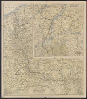
Enlarged scale map of territory between St. Quentin, La Fère and Laon, How to recognize the arms of the service., and Proper way to read military insignia.
Description:
"Supplement to Curtiss "Flyleaf," Curtiss Aeroplane and Motor Corporation, Buffalo, N.Y., U.S.A.", Inset: Enlarged scale map of territory between St. Quentin, La Fère and Laon. Scale [ca. 1:140,000]., On verso: How to recognize the, and Relief shown by shading.
Publisher:
Curtiss Aeroplane and Motor Corp.,
Subject (Geographic):
Belgium--Maps and France--Maps
Subject (Topic):
World War, 1914-1918--Belgium--Maps and World War, 1914-1918--France--Maps
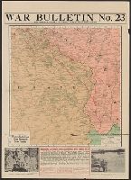
Map of the Western Battle Front from Verdun to Swiss Frontier
Description:
Photographs on margins: Wounded U.S. Marines arriving at a base hosipital -- Inflating a messenger balloon to use in dropping allied propaganda over the German Lines. and Text: Americans capture St. Mihiel Salient and move toward Metz.
Publisher:
The Kenyon Company,
Subject (Geographic):
France--Maps, Germany--Maps, and Switzerland--Maps
Subject (Topic):
World War, 1914-1918--France--Maps, World War, 1914-1918--Germany--Maps, and World War, 1914-1918--Switzerland--Maps