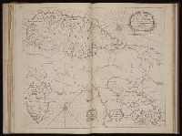
Twenty four new and accurate maps of the several parts of Europe ... : all (except the last) new
Image Count:
1
Alternative Title:
The world in general
Description:
In pencil on verso: 1.
Subject (Name):
Barker, B. (Benjamin), d. 1764, bookseller, Clements, Henry, d. 1719, bookseller, King, Charles, d. 1735, bookseller, Nicholson, John, d. ca. 1717, bookseller, Parker, Richard, fl. 1692-1725, bookseller, and Tooke, Benjamin, d. 1716, bookseller
Subject (Topic):
Atlases --Early works to 1800 and World maps --Early works to 1800
Collection Created:
[London] : Sold by J. Nicholson at the King’s-Arms in Little Britain, Benj. Barker and Charles King ..., Benj. Tooke ..., Hen. Clements ..., R. Parker and Ralph Smith under the Royal-Exchange ..., [1715?]
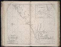
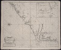
The English pilot: describing the sea-coasts, capes, head-lands, rivers, bays, roads, havens
Image Count:
1
Description:
Most maps numbered in pencil on verso, some on recto.
Subject (Geographic):
Atlantic Ocean --Maps --Early works to 1800, North Carolina --Maps --Early works to 1800, and South Carolina --Maps --Early works to 1800
Subject (Topic):
Navigation --Early works to 1800, Pilot guides --Atlantic Coast (U.S.) --Early works to 1800, and Pilot guides --Caribbean Area --Early works to 1800
Collection Created:
London : Printed for John Thornton, at the sign of the England, Scotland, and Ireland, in the Minories, and Richard Mount, at the Postern on Tower-Hill, 1698London : Printed for John Thornton, at the sign of the England, Scotland, and Ireland, in the Minories, and Richard Mount, at the Postern on Tower-Hill, 1698
New map of Rome showing its ancient and present situation
Description:
Bar scales in 500 paces containing half an Italian mile and 528 paces being half an English mile., I. Harris, sculp., Insets: The ruins of yamphitheater Vespatian -- St Peters church &y Popes pallace -- Trajans Pillar -- The Sepulcher of Caijus Cestus., No. 20 of 69 maps bound together in composite atlas., Oriented with north towards left., Plan view Rome, Italy with relief shown pictorially., and Scale not given.
Publisher:
By Christopher Browne at the Globe near the west end of St. Pauls
New map of the kingdom of England and Dominion of Wales, New map of the kingdome of England and Wales, and New mapp of the kingdom of England and Dominion of Wales
Description:
Imperfect: upper right of map mutilated, with some loss of text., No. 4 of 69 maps bound together in composite atlas., Relief shown pictorially., Scale [ca. 1:1 110 000]., With an alphabeticall table of all the cities and market towns in England and Wales., and With dedication To the most serene and most sacred Majesty William III ... from William Berry.
Publisher:
Sold by William Berry at the sign of the Globe between Charing Cross and White Hall
Subject (Geographic):
Great Britain --Maps --Early works to 1800
Subject (Topic):
Roads --Great Britain --Maps --Early works to 1800
[Atlas nouveau contenant toutes les parties du monde ou sont exactement marques les empires
Image Count:
1
Resource Type:
Maps, Atlases & Globes
Abstract:
Factitious collection of about 549 maps taken from the atlases of the 17th and the beginning of the 18th century, put together with the title "Atlas" and bound in 6 volumes. These volumes originally bore the imprint: Amstelaedamii apvd Reiniervm & Josvam Ottens. Over these words on the title pages of volumes 1-2 and 4-6 is the name of Henrik de Leth who painted them.
Description:
Verso blank.
Subject (Geographic):
British Isles --Maps --Early works to 1800
Subject (Name):
Leth, Hendrik de, 1703-1766, Reiner et Josua Ottens (Firm), Schenck, Peter, 1661-1715, Schenck, Peter, ca. 1698-1752, Valck, G. (Gerard), 1651 or 2-1726, and Wit, Frederik de
Subject (Topic):
Atlases --Early works to 1800
Collection Created:
[A Amsterdam, chez J. Covens & C. Mortier, ca. 1730-ca. 1800]