Search
You Searched For
Search Results
- Creator:
- Scott, F. H., Major, cartographer
- Published / Created:
- 1855.
- Call Number:
- Covers 59 1855
- Image Count:
- 4
- Resource Type:
- cartographic image
- Found in:
- Beinecke Rare Book and Manuscript Library > Map of the peninsula of India, comprising the whole of the Madras Presidency, and portions of the adjacent territories of Bengal and Bombay [cartographic material]
- Creator:
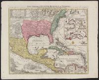
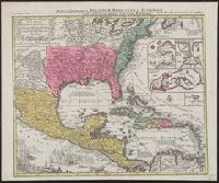
- Lotter, Tobias Conrad, 1717-1777, cartographer
- Published / Created:
- [between 1741 and 1760]
- Call Number:
- 85 1740D
- Image Count:
- 1
- Resource Type:
- cartographic image
- Found in:
- Beinecke Rare Book and Manuscript Library > Mappa geographica regionem Mexicanam et Floridam terrasque adjacentes, ut et anteriores Americae insulas, cursus itidem et reditus navigantium versus flumen Missisipi et alias colonias ob oculos ponens / [cartographic material]
- Creator:
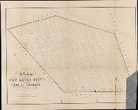
- Searl, S. W., cartographer
- Published / Created:
- [1863]
- Call Number:
- BrSides Folio 2014 10
- Image Count:
- 2
- Resource Type:
- cartographic image
- Found in:
- Beinecke Rare Book and Manuscript Library > Plan of the New Haven City burial ground
- Published / Created:
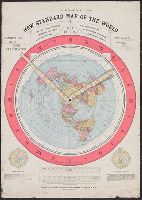
- 1892.
- Call Number:
- 11 1892
- Image Count:
- 2
- Resource Type:
- cartographic image
- Found in:
- Beinecke Rare Book and Manuscript Library > Gleason's new standard map of the world : on the projection of J.S. Christopher, Modern College, Blackheath, England ; scientifically and practically correct ; as "it is."
- Creator:
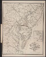
- J.L. Smith Co., cartographer, publisher
- Published / Created:
- 1874.
- Call Number:
- 754gme 1874
- Image Count:
- 1
- Resource Type:
- cartographic image
- Found in:
- Beinecke Rare Book and Manuscript Library > Map of the Baltimore, Chesapeake & Delaware Bay Railroad
- Creator:
- Lotter, Tobias Conrad, 1717-1777, cartographer
- Published / Created:
- [between 1741 and 1760]
- Call Number:
- 71 1737A
- Image Count:
- 1
- Resource Type:
- cartographic image
- Found in:
- Beinecke Rare Book and Manuscript Library > Mappa geographica regionem Mexicanam et Floridam terrasque adjacentes, ut et anteriores Americae insulas, cursus itidem et reditus navigantium versus flumen Missisipi et alias colonias ob oculos ponens / [cartographic material]
- Creator:
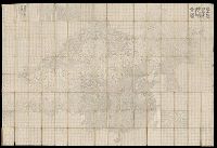
- Dong, Fangli, active 19th century, cartographer
董方立, active 19th century, cartographer
- Published / Created:
- Daoguang 12 [1842]
- Call Number:
- Covers 56 +1842
- Image Count:
- 1
- Resource Type:
- cartographic image
- Found in:
- Beinecke Rare Book and Manuscript Library > Huang chao yi tong yu di quan tu, 皇朝壹統輿地全圖
- Creator:
- Volčić, Vicko Dimitrije, 1563-1607, cartographer
- Published / Created:
- [1601]
- Call Number:
- Manuscript 49cea 1601
- Image Count:
- 2
- Resource Type:
- cartographic image
- Found in:
- Beinecke Rare Book and Manuscript Library > [Portolan chart of the Mediterranean Sea].
- Creator:
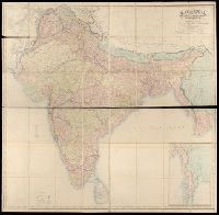
- Walker, John, 1786-1873, cartographer
- Published / Created:
- 1882.
- Call Number:
- Covers 59 +1882
- Image Count:
- 2
- Resource Type:
- cartographic image
- Found in:
- Beinecke Rare Book and Manuscript Library > Map of India : shewing the British territories, subdivided into collectorates and including British Burmah, with the position and boundary of each native state