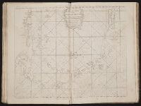
The English pilot: describing the West-India navigation, from Hudson's-Bay to the river Amazones
Image Count:
1
Subject (Geographic):
Atlantic Ocean --Maps --Early works to 1800, Dominican Republic --Maps, Manuscript --Early works to 1800, Haiti --Maps --Early works to 1800, Hispaniola --Maps --Early works to 1800, and West Indies --Maps --Early works to 1800
Subject (Topic):
Navigation --Early works to 1800, Pilot guides --Atlantic Coast (U.S.) --Early works to 1800, and Pilot guides --Caribbean Area --Early works to 1800
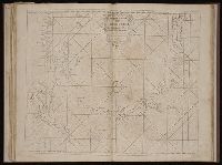
The English pilot: describing the West-India navigation, from Hudson's-Bay to the river Amazones
Image Count:
1
Resource Type:
Maps, Atlases & Globes
Subject (Geographic):
Atlantic Ocean --Maps --Early works to 1800, Dominican Republic --Maps, Manuscript --Early works to 1800, Haiti --Maps --Early works to 1800, Hispaniola --Maps --Early works to 1800, and West Indies --Maps --Early works to 1800
Subject (Topic):
Navigation --Early works to 1800, Pilot guides --Atlantic Coast (U.S.) --Early works to 1800, and Pilot guides --Caribbean Area --Early works to 1800
Collection Created:
London : Printed for W. and J. Mount, T. Page and son, on Tower-Hill, MDCCLIX [1759]
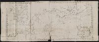
The English pilot: describing the West-India navigation, from Hudson's-Bay to the river Amazones
Image Count:
1
Subject (Geographic):
Atlantic Ocean --Maps --Early works to 1800, Boston Harbor (Mass.) --Maps --Early works to 1800, New England --Maps --Early works to 1800, and Nova Scotia --Maps --Early works to 1800
Subject (Topic):
Navigation --Early works to 1800, Pilot guides --Atlantic Coast (U.S.) --Early works to 1800, and Pilot guides --Caribbean Area --Early works to 1800
Collection Created:
London : Printed for W. and J. Mount, T. Page and son, on Tower-Hill, MDCCLX [1760]
The English pilot: describing the West-India navigation, from Hudson's-Bay to the river Amazones
Image Count:
1
Subject (Geographic):
Atlantic Ocean --Maps --Early works to 1800, Boston (Mass.) --Maps --Early works to 1800, Boston Harbor (Mass.) --Maps --Early works to 1800, New England --Maps --Early works to 1800, New York (State) --Maps --Early works to 1800, and Rhode Island --Maps --Early works to 1800
Subject (Topic):
Navigation --Early works to 1800, Pilot guides --Atlantic Coast (U.S.) --Early works to 1800, and Pilot guides --Caribbean Area --Early works to 1800
BEIN 2003 Folio 85: No. 7 of 45 maps bound together with binder's spine title: Atlas of America; ms. table of contents. Bookplate of Paul Mellon., Engraved by: Thomas Jefferys, geographer to his majesty., Hand-colored., Kershaw, Kenneth. Early printed maps of Canada, vol. 4, no. 1015., Map shows details of British and French positions during the siege of Quebec and table of references identifies British military units., Overlay provides details of changed position of British troops at the battle of September 13, 1759., Published in: A general topography of North America, London, 1768., and Scale 1:18,500.
Publisher:
Thos. Jefferys, the corner of St. Martins Lane Charing Cross
Subject (Geographic):
QueÌbec (QueÌbec) -- Maps -- Early works to 1800, QueÌbec Campaign, 1759 -- Maps, and United States -- History -- French and Indian War, 1755-1763 -- Maps
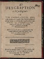
Colophon reads: At London printed the 18. of Iune, in the yeere of our Lord 1616., Page [3] at end blank., Signatures: [par.]⁴ A⁴ B-I⁴ [*]¹., and The list of old and new names inserted between A4 and B1 instead of at end; with Smith's map of New England in the 9th state (of Church cat.). Label: George Brinley, 359.
Publisher:
Printed by Humfrey Lownes, for Robert Clerke; and are to be sould at his house called the Lodge, in Chancery lane, ouer against Lincolnes Inne,
Subject (Geographic):
New England -- Maps -- Early works to 1800 and New England--Description and travel--Early works to 1800
Atlas minor: or a set of sixty-two new and correct maps, of all parts of the world. All composed
Image Count:
1
Description:
Autograph of Gravely. Autograph of Baldock. Autograph of Aston. Autograph of W. Alington. and Teaching resource: Professor John Mack Faragher, History 141: The American West.
Subject (Geographic):
America--Maps--Early works to 1800 and Fundy, Bay of--Maps