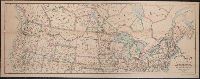
"Engraved by J.M. Atwood. N.Y.", "Showing the proposed routes to the Pacific Ocean.", Relief shown by hachures., and Shows canals, steamboat lines, finished and unfinished railroads.
Publisher:
J. Disturnell,
Subject (Geographic):
Canada--Maps and United States--Maps
Subject (Name):
Disturnell, John, 1801-1877
Subject (Topic):
Railroads--Canada--Maps and Railroads--United States--Maps
Carl I. Wheat map collection. CU-BANC and New map of the United States and Canada
Description:
Covers southern Canada, including New Brunswick, Prince Edward Island, and Nova Scotia., Inset: Map of Oregon, California, New Mexico & c. [continuation of main map, 1:10,600,000], and Main map extends west to cover most of Montana, Wyoming, Colorado, most of N
Publisher:
Published by J. Disturnell,
Subject (Geographic):
Canada--Maps and United States--Maps
Subject (Name):
Atwood, John M., b. ca. 1818 and Disturnell, John, 1801-1877
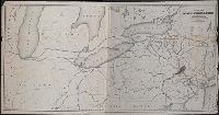
Map of the great railroad routes from the Middle Atlantic ports to the Mississippi River., Map of the railroads of New England and eastern N. York., and Map of the United States & Canada
Description:
Includes statistical charts: Population of the United States (by state and territory, 1790-1860) -- Ratio of slaves to total population -- Positions of forts., Insets: Map of the great railroad routes fr, Prime meridian: Greenwich., and Relief shown by hachures.
Publisher:
G.Q. Colton,
Subject (Geographic):
Canada--Maps and United States--Maps
Subject (Topic):
Railroads--New England--Maps, Railroads--New York (State)--Maps, and Railroads--United States--Maps
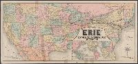
"Jno. B. Loveland, Gen'l European Passenger Agent, Liverpool, England.", "Martin B. Brown, Railroad Printer, 49 & 51 Park Place, New York.", Includes text and timetables on verso., Inset: Around the world, across the American continent via Erie Railway., and Show
Publisher:
Rand, McNally & Co.,
Subject (Name):
New York, Lake Erie, and Western Railroad Company and New York, Lake Erie, and Western Railroad Company--Maps
"12-20'27" and "5410." and Includes inset of "Canadian Pacific Railway and steamship lines."
Publisher:
Poole Bros.,
Subject (Geographic):
Canada--Maps and United States--Maps
Subject (Name):
Canadian Pacific Railway Company, Duluth, South Shore, and Atlantic Railway Company, Duluth, South Shore, and Atlantic Railway Company--Maps, and Spokane International Railway--Maps
Subject (Topic):
Railroads--Canada--Maps and Railroads--United States--Maps
Sportsman's map of Canada and the Northwest Territory.
Description:
Date taken from Yale card catalog indicating map was originally in cover with date of issue, March 1901; also with a cover title, "The sportsman's map of Canada and the Northwest Territory." and Relief shown by hachures.
Publisher:
Poole Bros.,
Subject (Geographic):
Canada--Maps and United States--Maps
Subject (Name):
Canadian Pacific Railway Company, Canadian Pacific Railway Company--Maps, Duluth, South Shore, and Atlantic Railway Company, and Duluth, South Shore, and Atlantic Railway Company--Maps
Subject (Topic):
Railroads--Canada--Maps and Railroads--United States--Maps
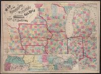
"Entered according to Act of Congress in the year 1858, by J.H. Colton & Co., in the Clerk's Office of the District Court for Southern District of New York.", Illustration within title: "Bridge across the west channel of the Mississippi at Davenport.", and Inse
Publisher:
J.H. Colton & Co.,
Subject (Geographic):
Middle West--Maps. and United States--Maps
Subject (Name):
Streeter, Thomas W.--(Thomas Winthrop),--1883-1965--Stamp.
Subject (Topic):
Railroads--Middle West--Maps and Railroads--United States--Maps