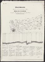
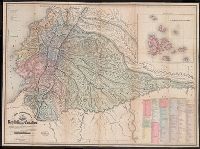
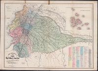
Description derived from published bibliography. and Panoramic map, with Round Top in the foreground, showing roads, railroads, field patterns, woodland, observation towers, monuments, and houses.
Carte de la Louisiane ou des voyages du Sr. De La Salle
Description:
"Reduced facsimile of MS. copy (made in Paris for Francis Parkman), now in the Library of Harvard University. The original, formerly in the Archives de la Marine, Paris, has been lost.", Facsimile., From the Jesuit Relations, vol. 63, frontispiece., and Relief shown pictorially.
Publisher:
s.n.,
Subject (Geographic):
New France--Maps--Early works to 1800--Facsimiles. and North America--Maps--Early works to 1800--Facsimiles.
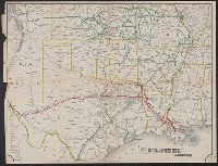
Map of the Texas & Pacific Railway and connections, Map of the Texas and Pacific Railway and connections, Texas & Pacific Railway and connections, and Texas and Pacific Railway and connections
Description:
Relief shown by hachures. and Shows Texas & Pacific Railway in red.
Publisher:
s.n.,
Subject (Name):
Texas & Pacific Railway--Maps
Subject (Topic):
Railroads--Southwestern States--Maps and Railroads--Texas--Maps
Part of the boundary between the United States and Texas, north of Sabine River from the 36th to the 72nd mile mound
Description:
"Though the map ... has an 1840 date, it appears from a letter of J.H. Overton, United States Commissioner, dated Opelousas, Louisiana, August 10, 1841 ... and the reply of October 1, 1841 ... that the maps ... had not been forwarded at that time. However, they had been received by January 15, 1842 ... and that they were issued by March 17, 1842, is shown by the reprintings of them accompanying the President's message of that date"--Streeter, T.W. Bibliography of Texas, 1438., At head of title: B.2., From the Streeter collection., Relief shown by hachures., and Three parallel sections of 12 miles each.
Publisher:
s.n.,
Subject (Geographic):
Texas--Boundaries--United States--Maps and United States--Boundaries--Texas--Maps
Subject (Name):
Streeter, Thomas W.--(Thomas Winthrop),--1883-1965--Ownership
"Though the map ... has an 1840 date, it appears from a letter of J.H. Overton, United States Commissioner, dated Opelousas, Louisiana, August 10, 1841 ... and the reply of October 1, 1841 ... that the maps ... had not been forwarded at that time. However, they had been received by January 15, 1842 ..and that they were issued by March 17, 1842, is shown by the reprintings of them accompanying the President's message of that date"--Streeter, Bibliographof Texas, 1438., At head of title: A.2., From the Streeter collection., Relief shown by hachures., and Three parallel sections of 12 miles each.
Publisher:
s.n.,
Subject (Geographic):
Texas--Boundaries--United States--Maps and United States--Boundaries--Texas--Maps
Subject (Name):
Streeter, Thomas W.--(Thomas Winthrop),--1883-1965--Ownership
Red River, Sabine & Western Railway and Red River, Sabine and Western Railway
Description:
"I.[?] C. Terry, Chf. Eng.", Covers Texas and Louisiana, and parts of New Mexico, Indian Territory, Arkansas, Mississippi, and northern Mexico., From the Streeter collection., and Library's copy imperfect: Holes in center.
Publisher:
s.n.,
Subject (Name):
Red River, Sabine and Western Railway--Maps and Streeter, Thomas W.--(Thomas Winthrop),--1883-1965--Ownership
Subject (Topic):
Coal--Texas--Maps, Forests and forestry--Louisiana--Maps, Forests and forestry--Texas--Maps, Iron--Texas--Maps, Petroleum--Texas--Maps, Railroads--Louisiana--Maps, and Railroads--Texas--Maps
"S.N. Simpson, real estate dealer, office 505 Delaware St., Kansas City and at Riverview.", Riverview map includes text., and Shows numbered lots and property owners.
Publisher:
s.n.,
Subject (Geographic):
Kansas City Metropolitan Area (Kan.)--Maps, Kansas City Metropolitan Area (Mo.)--Maps, and Riverview (Kan.)--Maps
Subject (Name):
O'Flaherty, Daniel, civil eng'r, Ramsey, Millett & Hudson, Simpson, S. N, and Smith, D. M
Subject (Topic):
Real property--Kansas--Kansas City Metropolitan Area--Maps, Real property--Kansas--Riverview--Maps, and Real property--Missouri--Kansas City Metropolitan Area--Maps
Blue line print., Shows landowners, oil and gas wells, abandoned wells, dry holes, railroads, and Prairie pipeline., and Title devised by cataloger.
Publisher:
s.n.,
Subject (Name):
Tarbell, F. S. (F. Scott)
Subject (Topic):
Gas wells--Kansas--Anderson County--Maps, Landowners--Kansas--Anderson County--Maps, Oil wells--Kansas--Anderson County--Maps, and Real property--Kansas--Anderson County--Maps
Stamped on verso: The Library of Congress duplicate ... Jan. 1945., Stamped: Chamber of Commerce, Coffeyville, Kansas., and Title devised by cataloger.
In bottom margin: Photolithographed preliminary sheet for the use of the parties in the field and subject to revision., In top margin: Northe, Library's copy separated into two sheets (59 x 58 cm. and 59 x 55 cm.)., and Relief shown by contours and spot heights.
Publisher:
Northern Transcontinental Survey?],
Subject (Geographic):
Judith River Watershed (Mont.)--Maps, Topographic
Subject (Name):
Julius Bien & Co, Northern Transcontinental Survey. Topographical Dept, and Owen, F. D
Blueprint., In lower left: 77., Includes note certifying map., Relief shown by hachures., and Shows trails of Genl. Miles, Col. Baker, Capt. Snyder, and Lt. Woodruff in lands near Missouri and Yellowstone rivers in Montana.
Publisher:
s.n.,
Subject (Geographic):
Montana--Maps, Military and Yellowstone River Valley--Maps, Military
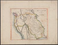
"Delineada en vista de las cartas de Don Pedro Maldonado, el Baron de Humboldt, Mr. Wisse, la de las sontas de las costas por M.M. Filzroy i H. Kellet i las particular, Includes table of names of provinces, cantons, parishes, etc., and Relief shown by hachures.
"Delineada en vista de las cartas de Don Pedro Maldonado, el Baron de Humboldt, Mr. Wisse, la de las sontas de las costas por M.M. Filzroy i H. Kellet i las particular, Includes table of names of provinces, cantons, parishes, etc., and Relief shown by hachures.
A strip of paper has been overlaid within the lower left neat line., Central Venice and some outlying areas appear finished, but there are extensive unfinished areas with notations in pencil., dgvmp2008., and Map extends beyond neat lines.
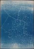
Blue line print., In lower left corner: R.W.D., Nov. 21, 1910. R 12-1-10. S, 4/1/12-S2 4/1/12., In lower right margin: Tolland Co. Conn, 905., and Indicates lettered routes, post offices, houses, schools, churches, and collection boxes.
Publisher:
s.n.],
Subject (Geographic):
Tolland County (Conn.)--Maps
Subject (Topic):
Postal service--Connecticut--Tolland County--Maps and Rural free delivery--Connecticut--Tolland County--Maps
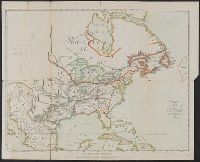
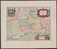
Appears in Jansson's Atlas novus, vol. 1, ca. 1680; also appears in the English Atlas, vol. 1, by Moses Pitt et al., ca. 1680., Bottom center: "Ex officina Janssonio-Waesbergiana, et Mosis Pitt.", Relief shown pictorially., and Sheet measures 54 x 62 cm. Numbered "6" in ink ms. Lada-Mocarski Collection.
Publisher:
s.n.,
Subject (Geographic):
Russia--Maps--Early works to 1800
Subject (Name):
Jansson, Jan, 1588-1664. Atlas novus and Pitt, Moses, active 1654-1696. English atlas
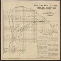
"Offices: J.M. Clifford ... Idaho. Fowler & Lummis ... Pa. International Immigrant Union ... Ill. Wm. H. Martin, manager.", Date inferred from latest date mentioned in text., and Includes text.
Publisher:
s.n.,
Subject (Geographic):
Bingham County (Idaho)--Maps
Subject (Name):
International Immigrant Union, Matthews-Northrup Company, and Snake River Water Co
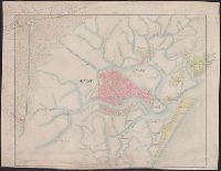
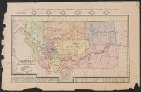
Includes inset of numbered lots between River and High, First and Eighth streets, list of mines, and text describing Wallace's location. and Relief shown by hachures and shading.