Skip to search
Skip to main content
Skip to first result
Search
You Searched For
Genre
Maps
Language
English
Publication Place
Philadelphia :
New Search
Search Results
Published / Created:
1795
Call Number:
327 1795B
Container / Volume:
BRBL_00072
Image Count:
1
Resource Type:
Maps, Atlases & Globes
Description:
From Carey's American Edition of Guthrie's Geography Improved.
Publisher:
Mathew Carey,
Subject (Geographic):
Ireland--Maps--Early works to 1800
Found in:
Beinecke Rare Book and Manuscript Library > A Map of Ireland according to the best authorities.
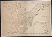
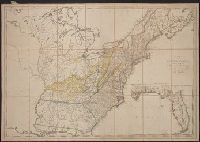
Published / Created:
1809
Call Number:
755 1809A
Container / Volume:
BRBL_00438
Image Count:
1
Resource Type:
Maps, Atlases & Globes
Description:
Inset: Florida.
Publisher:
Engraved for and sold by Matthew Carey,
Subject (Geographic):
Canada--Maps and East (U.S.)--Maps
Found in:
Beinecke Rare Book and Manuscript Library > A Map of the United States: compiled chiefly from the State Maps, and other Authentic Information, by Saml. Lewis.
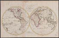
Published / Created:
1795
Call Number:
11 1795
Container / Volume:
BRBL_00006
Image Count:
1
Resource Type:
Maps, Atlases & Globes
Description:
From Carey's American Edition of Guthrie's Geography Improved.
Publisher:
Mathew Carey,
Subject (Geographic):
World--Maps--Early works to 1800
Found in:
Beinecke Rare Book and Manuscript Library > A Map of the World from the best Authorities.
Published / Created:
1795
Call Number:
85 1795
Container / Volume:
BRBL_00637
Image Count:
1
Resource Type:
Maps, Atlases & Globes
Description:
From Carey's American Edition of Gutherie's Geography Improved., Negative on file., and W. Baker, sculp.
Publisher:
Mathew Carey,
Subject (Geographic):
West Indies--Maps--Early works to 1800
Found in:
Beinecke Rare Book and Manuscript Library > A chart of the West Indies, from the latest marine Journals and Surveys.
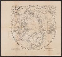
Creator:
Published / Created:
[1860]
Call Number:
18 1860A
Container / Volume:
BRBL_00013
Image Count:
1
Resource Type:
Maps, Atlases & Globes
Description:
Includes note., Inset: Chart of Smith Strait and Kennedy Channel., and Shows northern hemisphere (34 diam.).
Publisher:
Bowen & C[o] Lith.,
Subject (Geographic):
Arctic regions--Discovery and exploration--Maps
Found in:
Beinecke Rare Book and Manuscript Library > A chart of the arctic regions : projected from Berghaus & Petermann, the charts of E.K. Kane, materials in the British Hydrographic office, etc. / eng. by W. Boell.
Creator:
Published / Created:
[1822 or 1823]
Call Number:
71 1822
Container / Volume:
BRBL_00369
Image Count:
4
Resource Type:
Maps, Atlases & Globes
Description:
In bottom left margin: Printed by Wm. Duffee., In top margin: American atlas., Includes text, ill., and insets of "Western part of the Aleutian Islands" and "Comparative altitudes of the mountains, towns &c. of North America.", and Possibly from 1923 ed. of Tanner's A new American atlas.
Publisher:
H.S. Tanner,
Subject (Geographic):
Central America--Maps and North America--Maps
Subject (Name):
Tanner, Henry Schenck, 1786-1858. New American atlas
Found in:
Beinecke Rare Book and Manuscript Library > A map of North America : constructed according to the latest information / engraved & published by H.S. Tanner, Philadelphia 1822.
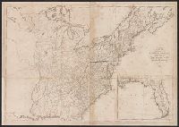
Published / Created:
1795
Call Number:
75 1795
Container / Volume:
BRBL_00396
Image Count:
1
Resource Type:
Maps, Atlases & Globes
Description:
5 copies. 2 copies damaged.
Publisher:
Matthew Carey,
Subject (Geographic):
United States--Maps--Early works to 1800
Found in:
Beinecke Rare Book and Manuscript Library > A map of the United States; Compiled chiefly from the State maps, and other authentic information, by Saml. Lewis. W. Harrison Jun. Sculp.
Branch:v1.61.6 ,Deployed:2024-06-12T09:55:37-04:00