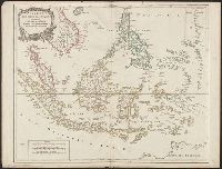
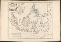
Covers present-day Indonesia, the Philippines, Malayan peninsula, Indo-Chinese peninsula, and north-west coast of Australia., From: Atlas universel / par m. Robert geographe et Robert de Vaugondy son fils. Paris, 1757-[1786]., Includes inset map., and Inset: Isl
Publisher:
[publisher not identified],
Subject (Geographic):
Asia--East Indies, Australia--Maps--Early works to 1800., East Indies--Maps--Early works to 1800., Mariana Islands--Maps--Early works to 1800., and Southeast Asia--Maps--Early works to 1800.
Subject (Name):
Haye, G. de la, engraver. and Robert de Vaugondy, Gilles, 1688-1766. Atlas universel.
"Archipel des Indes" stamped twice on verso., Appeared in: Gilles and Didier Robert de Vaugondy, "Atlas Universel", 1753-1757 [or later]., Covers present-day Indonesia, the Philippines, Malayan peninsula, Indo-Chinese peninsula, and north-west coast of Australia., Includes inset map., Inset: Isles Marianes des Larons., Relief shown pictorially., and Watermarks.
Publisher:
[publisher not identified],
Subject (Geographic):
Southeast Asia--Maps--Early works to 1800.
Subject (Name):
Haye, G. de la, engraver., Robert de Vaugondy, Didier, 1723-1786. Atlas Universel., and Robert de Vaugondy, Gilles, 1688-1766. Atlas universel.
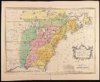
"Avec Privilege du Roi.", Insets: Map of territory west of Lake Superior; map of territory west of Florida; view of "Sault du Niagara, de 135 pieds de haut"., Relief shown pictorially., and Second state: contains two keys to colors "Couleur selon les pretentions des Anglois" and "Selon les pretentions de la France."
Publisher:
[Georges-Louis Le Rouge] Rue des Augustins,
Subject (Geographic):
Atlantic States--Maps--Early works to 1800., France--Colonies--America--Maps--Early works to 1800., Great Britain--Colonies--America--Maps--Early works to 1800., Maritime Provinces--Maps--Early works to 1800., and United States--History--French and Indian War, 1754-1763--Maps--Early works to 1800.
"Avec privilege du Roy.", "Se vend a Bruxelles chez Eugene Henry Fricx, imprimeur du Roy.", Includes "Avertissement.", Prime meridian: Ferro., Relief shown pictorially., and Shows east coast of Brazil.
"P. II. 44" in upper right corner., From P. Santini's Atlas universel, 1784., Prime meridians: Paris; Ferro. Coordinates converted by cataloger to express longitude as measured from the Greenwich meridian., Relief shown pictorially., and This edition was issued in Venice for Francesco Santini and Giuseppi Antonio Remondini's reissue of De L'Isle's Atlas universel.
Subject (Geographic):
Bering Strait Region--Discovery and exploration--Russian--Maps--Early works to 1800., North America--Discovery and exploration--Russian--Maps--Early works to 1800., Pacific Coast (North America)--Discovery and exploration--Maps--Early works to 1800., and Russian Far East (Russia)--Discovery and exploration--Russian--Maps--Early works to 1800.
Subject (Name):
L'Isle, Guillaume de, 1675-1726., Remondini, Giuseppi Antonio, 1747-1811, publisher., and Santini, P. Atlas universel.
Carte des possessions angloises et françoises du continent de l'Amérique septentrionale
Description:
"On trouvera dans le troisiéme volume de la Nouvelle introduction à la géographie moderne ..." at bottom., Appeared in Jean Palairet's Atlas methodique., Prime meridians: Ferro and London., Relief shown pictorially., and Variant with "Explication" in French and English and with additional boundary lines with titles in French drawn horizontally across the map.
Publisher:
[Jean Palairet],
Subject (Geographic):
France--Colonies--America--Maps--Early works to 1800., Great Britain--Colonies--America--Maps--Early works to 1800., North America--Maps--Early works to 1800., and United States--History--French and Indian War, 1755-1763--Maps