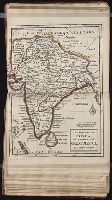
Vidal, A. T. E. (Alexander Thomas Emeric), 1792-1863, author
Call Number:
655 1827
Container / Volume:
BRBL_00345
Image Count:
1
Resource Type:
Maps, Atlases & Globes
Description:
Depths shown by isolines and soundings., Manuscript annotations on verso. Manuscript number in upper left corner: 666., Prime meridian: Greenwich., and Relief shown by hachures and spot heights.
Subject (Geographic):
Atlantic Coast (Africa)--Maps and South Atlantic Ocean--Navigation
Subject (Name):
Great Britain. Hydrographic Office, publisher, J. & C. Walker (Firm), engraver, Mudge, William, 1762-1820, and Owen, W. F. W., 1774-1857
Mounted on linen., Relief shown pictorially., and Variant without inset of "Fort Frederick oder Crown Point"; see B.B. McCorkle, Early printed maps of New England 1513-1800, 755.34.
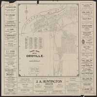
Butte County, California., Map of Oroville, California, and New 1928 map of Oroville, California
Description:
"Copyright by Geo. C. Thomas.", Includes index and advertisements., and Map of "Butte County, California" (scale [ca. 1:255,000], dated 4-23-28), location map, ill., and text of "Oroville, gateway to the Feather River country"on verso.
Publisher:
Thomas Bros., [1928]
Subject (Geographic):
Butte County (Calif.)--Maps and Oroville (Calif.)--Maps
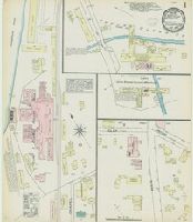
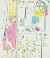
Sanborn fire insurance maps are a rich source of historic data on the urban built environment of North America during the 19th and early 20th centuries. The atlases were created for the purpose of underwriting fire insurance policies, which depended upon accurate and frequently-updated information about construction materials, municipal and transportation infrastructure, industrial and commercial landuse and more. The Yale University Library Map Department scanned its holdings of Sanborn fire insurance maps (consisting primarily of Connecticut towns) in order to make the maps more accessible.
Alternative Title:
May 1884, Thomaston, Conn.
Description:
"2 sheets.", Contains information on population, prevailing winds, water facilities and fire department., Partial cadastral map., and SMLMAPL 766 T36 1884: Sheets disbound. "Triplicate" stamp on both sheets. Library of Congress copyright stamp on title sheet.
Subject (Geographic):
Thomaston (Conn.)--Maps
Subject (Name):
Library of Congress Stamp
Subject (Topic):
Fire risk assessment--Connecticut--Thomaston--Maps and Real property--Connecticut--Thomaston--Maps
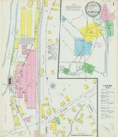
Sanborn fire insurance maps are a rich source of historic data on the urban built environment of North America during the 19th and early 20th centuries. The atlases were created for the purpose of underwriting fire insurance policies, which depended upon accurate and frequently-updated information about construction materials, municipal and transportation infrastructure, industrial and commercial landuse and more. The Yale University Library Map Department scanned its holdings of Sanborn fire insurance maps (consisting primarily of Connecticut towns) in order to make the maps more accessible.
Alternative Title:
Jan. 1890, Thomaston, Conn.
Description:
"3622. 3 sheets.", Contains information on population, prevailing winds, water facilities and fire department., Partial cadastral map., and SMLMAPL 766 T36 1890: Sheets disbound. "Triplicate" stamp on all sheets. Library of Congress copyright stamp on title sheet.
Subject (Geographic):
Thomaston (Conn.)--Maps
Subject (Name):
Library of Congress Stamp
Subject (Topic):
Fire risk assessment--Connecticut--Thomaston--Maps and Real property--Connecticut--Thomaston--Maps
Sanborn fire insurance maps are a rich source of historic data on the urban built environment of North America during the 19th and early 20th centuries. The atlases were created for the purpose of underwriting fire insurance policies, which depended upon accurate and frequently-updated information about construction materials, municipal and transportation infrastructure, industrial and commercial landuse and more. The Yale University Library Map Department scanned its holdings of Sanborn fire insurance maps (consisting primarily of Connecticut towns) in order to make the maps more accessible.
Alternative Title:
Oct. 1895, Thomaston, Conn.
Description:
"6. 4 sheets.", Contains information on population, prevailing winds, water facilities and fire department., Includes index of specials., Partial cadastral map., and SMLMAPL 766 T36 1895: Sheets disbound. "Triplicate" stamp on all sheets. Library of Congress copyright stamp on title sheet.
Subject (Geographic):
Thomaston (Conn.)--Maps
Subject (Name):
Library of Congress Stamp
Subject (Topic):
Fire risk assessment--Connecticut--Thomaston--Maps and Real property--Connecticut--Thomaston--Maps
Sanborn fire insurance maps are a rich source of historic data on the urban built environment of North America during the 19th and early 20th centuries. The atlases were created for the purpose of underwriting fire insurance policies, which depended upon accurate and frequently-updated information about construction materials, municipal and transportation infrastructure, industrial and commercial landuse and more. The Yale University Library Map Department scanned its holdings of Sanborn fire insurance maps (consisting primarily of Connecticut towns) in order to make the maps more accessible.
Alternative Title:
Sep. 1900, Thomaston, Conn.
Description:
"4 sheets. 4187.", Contains information on population, prevailing winds, water facilities and fire department., Includes index of specials., Partial cadastral map., and SMLMAPL 766 T36 1900: Sheets disbound. "Triplicate" stamp on all sheets. Library of Congress copyright stamp on title sheet.
Subject (Geographic):
Thomaston (Conn.)--Maps
Subject (Name):
Library of Congress Stamp
Subject (Topic):
Fire risk assessment--Connecticut--Thomaston--Maps and Real property--Connecticut--Thomaston--Maps