BEIN 2003 Folio 85: No. 25 of 45 maps bound together with binder's spine title: Atlas of America; ms. table of contents. Bookplate: Robinson. Bookplate of Paul Mellon., Hand colored., par le sr. d'Anville ; dresse en Mai 1732 ; publiee en 1752, and Scale [ca. 1:940,000].
Bellin, Jacques Nicolas, 1703-1772, creator France, Depot des cartes et plans de la marine
Published / Created:
1755?
Call Number:
2003 Folio 85
Image Count:
1
Description:
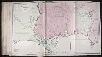
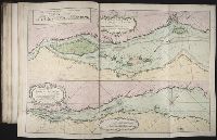
Available also through the Library of Congress Web site as a raster image., BEIN 2003 Folio 85: No. 23 of 45 maps bound together with binder's spine title: Atlas of America; ms. table of contents. Bookplate: Robinson. Bookplate of Paul Mellon., Covers the area from Quebec to the Gulf of Mexico and west of Santa Fe, N.M., Hand colored., LC Maps of North America, 1750-1789,, Longitude du meridien de l'ile de Fer., Par le Sr. Bellin, ingr. ordre. de la marine, 1750., Relief shown pictorially., Scale [ca. 1:5,800,000]., Shows cities and towns, forts, some trails, and Indian villages and tribal territory., and Sur de nouvelles observations on a corrige les lacs, et leurs environs, 1755.
Subject (Geographic):
Louisiana -- Maps -- Early works to 1800 and North America -- Maps -- Early works to 1800
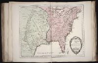
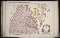
Fry, Joshua, 1700 (ca.)-1754 Haussard, Elisabeth. Jefferson, Peter, 1708-1757 Robert de Vaugondy, Gilles, 1688-1766 Robert de Vaugondy, Gilles, 1688-1766, creator
Published / Created:
1755
Call Number:
2003 Folio 85
Image Count:
1
Description:
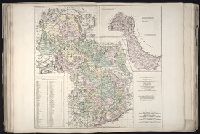
BEIN 2003 Folio 85: No. 22 of 45 maps bound together with binder's spine title: Atlas of America; ms. table of contents. Bookplate: Robinson. Bookplate of Paul Mellon., dressee sur la grande carte angloise de Mrs. Josue Fry et Pierre Jefferson ; par le Sr. Robert de Vaugondy, geographe ordinaire du Roi., Grave E. Haussard., Hand colored., Relief shown pictorially., Scale [ca. 1:870,000], and Shows Virginia, Maryland, and De La War counties.
Subject (Geographic):
Maryland -- Maps -- 1755, Maryland -- Maps -- Early works to 1800, Middle Atlantic States -- Maps -- 1755, Middle Atlantic States -- Maps -- Early works to 1800, Virginia -- Maps -- 1755, and Virginia -- Maps -- Early works to 1800
BEIN 2003 Folio 85: No. 11 of 45 maps bound together with binder's spine title: Atlas of America; ms. table of contents. Bookplate: Robinson. Bookplate of Paul Mellon., Hand colored., Leve sure les lieux a 6 lignes pour cent toises par le Sr Fortin, ingenieur geographe., par le Sr. Bellin, ingenieur de la Marine., Relief shown pictorially. Depths shown by soundings., and Scale [ca. 1:50,000].
Publisher:
s.n
Subject (Topic):
Coasts -- Saint Pierre and Miquelon -- Maps -- Early works to 1800 and Nautical charts -- Saint Pierre and Miquelon -- Early works to 1800
Bellin, Jacques Nicolas, 1703-1772, creator France, Depot des cartes et plans de la marine
Published / Created:
1791
Call Number:
2003 Folio 85
Image Count:
1
Description:
BEIN 2003 Folio 85: No. 6 of 45 maps bound together with binder's spine title: Atlas of America; ms. table of contents. Bookplate of Paul Mellon., Hand-colored., Includes insets Vue de terres du sud pour passer la traverse en remontant le fleuve and Partie du cours du fleuve de Saint Laurent depuis Quebec jusqu au cap aux Oyes, ca. 1:120,000., Par le S. Bellin ingenieur de la marine ... Dressee au Depost des cartes et plans de la marine. Pour le Service des vaisseaux du rou. Par ordre de M. Berryer, ministre et secretaire d'etat aiant le Departement de la marine., Relief shown pictorially and by hachures. Soundings shown in fathoms., and Scale ca. 1:415,000.
Publisher:
Depot de la Marine
Subject (Geographic):
Saint Lawrence River -- Maps -- Early works to 1800
Subject (Topic):
Nautical charts -- Saint Lawrence River -- Early works to 1800
No. 18 of 43 maps bound together in composite atlas., Reduite d'apres la grande carte pour trouver facilement ce qu'on a envie de chercher dans celle-la., Relief shown pictorially., Scale [ca 1:3,750,000]., Table alphabetique des villes ... qui se trouvent dans cette carte., and With inset map: Morceau detache qui represente l'acroissement des etats de sa majeste le roi de Sardaigne, depuis l'an 1680.
Bellin, Jacques Nicolas, 1703-1772, creator Choiseul, Etienne-François, duc de, 1719-1785 France, DeÌpoÌ?t des cartes et plans de la marine
Published / Created:
1762?
Call Number:
2003 Folio 85
Image Count:
1
Description:
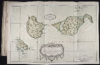
BEIN 2003 Folio 85: No. 30 of 45 maps bound together with binder's spine title: Atlas of America; ms. table of contents. Bookplate: Robinson. Bookplate of Paul Mellon., dressee au Depost des cartes et plans de la marine, pour le service des vaisseaux du roy ; par ordre de M. le duc de Choiseul, colonel general des suisses et grisons, ministre de la guerre et de la marine, 1762 par le S. Bellin, ingenieur de la marine., Hand colored., Includes index and insets of Le Fort du Maure, Le Fort de la Pointe, and Le Vieux Chateau., Relief shown by hachures. Soundings shown in feet., and Scale [ca. 1:12,500].
Publisher:
Depost des cartes et plans de la marine
Subject (Geographic):
Havana (Cuba) -- Buildings, structures, etc -- Maps -- Early works to 1800, Havana (Cuba) -- Maps -- Early works to 1800, and Havana Bay (Cuba) -- Maps -- Early works to 1800
Subject (Topic):
Fortification -- Cuba -- Havana -- Maps -- Early works to 1800 and Nautical charts -- Cuba -- Havana Bay -- Early works to 1800