Skip to search
Skip to main content
Skip to first result
Search
You Searched For
Extent of Digitization
Partially digitized
Resource Type
Maps, Atlases & Globes
New Search
Search Results
Creator:
Published / Created:
c1835.
Call Number:
2000 Folio 110
Image Count:
1
Resource Type:
Maps, Atlases & Globes
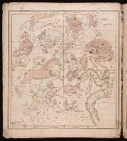
Alternative Title:
The geography of the heavens.
Description:
Cover title. and Original wrappers. Autograph on 2nd map: E.J. Bullock. Ms. annotations on wrapper. From the Kurt Seligmann Papers.
Publisher:
Huntington and Savage,
Subject (Name):
Berton, H. P.--Autograph., Bullock, E. J.--Autograph., Rodman, Sophia M. Loomis--Autograph., Sage & Brother, bookseller, and Seligmann, Kurt,--1900-1962--Ownership.
Subject (Topic):
Astronomy--Charts, diagrams, etc.
Found in:
Beinecke Rare Book and Manuscript Library > Atlas, designed to illustrate the geography of the heavens ... By Elijah H. Burritt ...
Call Number:
1973 Folio 114
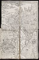
Collection Title:
The English pilot: describing the West-India navigation, from Hudson's-Bay to the river Amazones
Image Count:
1
Resource Type:
Maps, Atlases & Globes
Subject (Geographic):
Atlantic Ocean --Maps --Early works to 1800 and Barbados --Maps --Early works to 1800
Subject (Topic):
Navigation --Early works to 1800, Pilot guides --Atlantic Coast (U.S.) --Early works to 1800, and Pilot guides --Caribbean Area --Early works to 1800
Collection Created:
London : Printed for W. and J. Mount, T. Page and son, on Tower-Hill, MDCCLIX [1759]
Found in:
Beinecke Rare Book and Manuscript Library > Barbados
Call Number:
1973 Folio 114
Collection Title:
The English pilot: describing the West-India navigation, from Hudson's-Bay to the river Amazones
Image Count:
1
Resource Type:
Maps, Atlases & Globes
Subject (Geographic):
Atlantic Ocean --Maps --Early works to 1800 and Newfoundland and Labrador --Maps --Early works to 1800
Subject (Topic):
Navigation --Early works to 1800, Pilot guides --Atlantic Coast (U.S.) --Early works to 1800, and Pilot guides --Caribbean Area --Early works to 1800
Collection Created:
London : Printed for W. and J. Mount, T. Page and son, on Tower-Hill, MDCCLIX [1759]
Found in:
Beinecke Rare Book and Manuscript Library > Bay Bulls, part of Newfoundland
Creator:
Call Number:
1977 Folio 114
Collection Title:
L’atlas curieux ou Le monde represente dans des cartes generales et particulieres du ciel et de la
Image Count:
1
Resource Type:
Maps, Atlases & Globes
Description:
Verso blank.
Subject (Geographic):
Fontainebleau (France)
Subject (Topic):
Atlases, French
Collection Created:
A Paris, Chez l’auteur dans l’Isle du Palais sur le quay de l’Orloge a la Sphere Royale, 1700[-03]
Found in:
Beinecke Rare Book and Manuscript Library > Bourg, chateau, et iardins de Fontaine-bleau
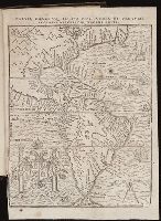
Published / Created:
[1567]
Call Number:
Peru Cwpr j567
Collection Title:
Levini Apollonii, Gandobrvgani, Mittelbvrgensis, de Peruuiae, regionis, inter Noui Orbis prouincias
Image Count:
1
Resource Type:
Maps, Atlases & Globes
Description:
Scale included.
Subject (Geographic):
Andes., Central America., Peru --History --Conquest, 1522-1548., and South America
Subject (Topic):
Discoveries in geography
Collection Created:
Antverpiae, Apud Ioannem Bellerum,
Found in:
Beinecke Rare Book and Manuscript Library > Brevis, exactaq totivs novi orbis et Pervviae regionis descriptio recens edita
Branch:v1.61.6 ,Deployed:2024-06-12T09:55:37-04:00