Skip to search
Skip to main content
Skip to first result
Search
You Searched For
Genre
Maps
Subject (Topic)
Railroads--United States--Maps
Publication Place
Chicago :
New Search
Search Results
Creator:
Published / Created:
1891, c1889.
Call Number:
75gme 1891
Container / Volume:
BRBL_00414
Image Count:
2
Resource Type:
Maps, Atlases & Globes
Alternative Title:
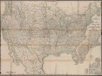
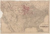
New official railroad map of the United States, Canada and Mexico.
Description:
Includes 9 insets., Northern Canada and southern Mexico not shown., On verso: Indexes and publisher's advertisements., and Relief shown by hachures.
Publisher:
Rand McNally,
Subject (Topic):
Railroads--Canada--Maps, Railroads--Mexico, North--Maps, Railroads--North America--Maps, and Railroads--United States--Maps
Found in:
Beinecke Rare Book and Manuscript Library > Rand McNally & Co.'s new official railroad map of the United States, Canada, and Mexico.
Creator:
Published / Created:
1873
Call Number:
75 1873
Container / Volume:
BRBL_00405
Image Count:
2
Resource Type:
Maps, Atlases & Globes
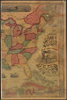
Description:
Across top of map: "Panoramic view of the country between San Francisco and St. Louis.", Includes ill., text, population information, and inset of "Central America.", Prime meridians: Washington and Greenwich., and Relief shown by hachures.
Publisher:
Geo. F. Cram,
Subject (Geographic):
United States--Maps
Subject (Topic):
Railroads--United States--Maps
Found in:
Beinecke Rare Book and Manuscript Library > The Improved American Union Railroad map of the United States, British provinces, West Indies, Mexico and Central America.
Branch:v1.61.8 ,Deployed:2024-06-20T11:15:04-04:00