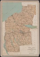
Relief shown by spot heights. and Shows roads, railroads, settlements, original patents, towns, Onondaga Indian Reservation, etc.
Publisher:
Julius Bien & Co.,
Subject (Geographic):
Cayuga County (N.Y.)--Maps, Onondaga County (N.Y.)--Maps, and Oswego County (N.Y.)--Maps
Subject (Name):
Bien, Joseph R. Atlas of the state of New York, New York : Julius Bien & Co., 1895. pl. 27 and Julius Bien & Co
Subject (Topic):
Land grants--New York (State)--Cayuga County--Maps, Land grants--New York (State)--Onondaga County--Maps, and Land grants--New York (State)--Oswego County--Maps
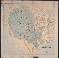
"No I.", "To accompany a report in reply to a resolution of the House of Representatives dated Feb 16th, 1885"., and Shows cattle trails, quarantine lines, "assumed northern limit of Texas fever district", railroads, cities and towns, Indian reservations, rivers, and isotherms.
Publisher:
Julius Bien & Co.,
Subject (Name):
Julius Bien & Co, Nimmo, Joseph, 1837-1909, and United States. Dept. of the Treasury. Report on the internal commerce of the United States
Subject (Topic):
Railroads--West (U.S.)--Maps and Rangelands--West (U.S.)--Maps
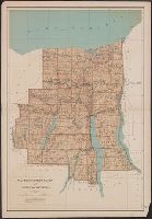
Relief shown by spot heights. and Shows roads, railroads, settlements, original patents, towns, etc.
Publisher:
Julius Bien & Co.,
Subject (Geographic):
Ontario County (N.Y.)--Maps, Seneca County (N.Y.)--Maps, Wayne County (N.Y.)--Maps, and Yates County (N.Y.)--Maps
Subject (Name):
Bien, Joseph R. Atlas of the state of New York, New York : Julius Bien & Co., 1895. pl. 29 and Julius Bien & Co
Subject (Topic):
Land grants--New York (State)--Ontario County--Maps, Land grants--New York (State)--Seneca County--Maps, Land grants--New York (State)--Wayne County--Maps, and Land grants--New York (State)--Yates County--Maps