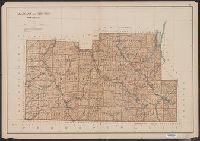
"Copyright 1895, Julius Bien & Company N.Y.", From: Atlas of the state of New York. New York : Julius Bien & Co., 1895., Maps prepared by Joseph Bien., Relief shown by spot heights., and Shows roads, railroads, settlements, original patents, towns, Oil Spring Res
Publisher:
Julius Bien & Co.,
Subject (Geographic):
Allegany County (N.Y.)--Maps and Steuben County (N.Y.)--Maps
Subject (Name):
Bien, Joseph R. Atlas of the state of New York and Julius Bien & Co
Subject (Topic):
Land grants--New York (State)--Allegany County--Maps and Land grants--New York (State)--Steuben County--Maps
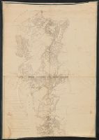
no. 1. Yorktown to Williamsburg -- no. 2. Williamsburg to White House -- no. 3. White House to Harrison's Landing., Relief shown by hachures., and Yale copy: each sheet comprises 4 sections, mounted on linen. "Photographed at the Coast Survey office." Shows no
Publisher:
Corps of Engineers?]
Subject (Geographic):
Virginia Peninsula (Va.)--Maps
Subject (Name):
Dougal, William H., 1822-1895, Humphreys, A. A. (Andrew Atkinson), 1810-1883, Julius Bien & Co, United States Coast Survey., and United States. Army of the Potomac
Subject (Topic):
Peninsular Campaign, 1862--Maps and Williamsburg, Battle of, Williamsburg, Va., 1862--Maps
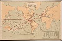
Includes "Table showing distances in miles between commercial ports of the world and distances saved by the Nicaragua Canal." and Shows "present routes" in black and "new routes via Nicaragua canal" in red.
Publisher:
Julius Bein & Co., Photo. Lith.,
Subject (Geographic):
Nicaragua Canal (Nicaragua)--Maps. and Nicaragua--Nicaragua Canal
From: Atlas of the state of New York. New York : Julius Bien & Co., 1895., Maps prepared by Joseph, Relief shown by spot heights., and Shows roads, railroads, settlements, original patents, towns, Allegany Indian Reservation, Cattaraugus Indian Reservation, etc.
Publisher:
Julius Bien & Co.,
Subject (Geographic):
Cattaraugus County (N.Y.)--Maps and Chautauqua County (N.Y.)--Maps
Subject (Name):
Bien, Joseph R. Atlas of the state of New York and Julius Bien & Co
Subject (Topic):
Land grants--New York (State)--Cattaraugus County--Maps and Land grants--New York (State)--Chautauqua County--Maps
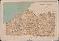
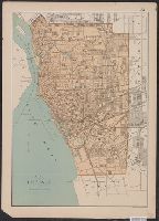
"Copyright 1895, Julius Bien & Company N.Y.", From: Atlas of the state of New York. New York : Julius Bien & Co., 1895., Maps prepared by Joseph Bien., and Shows streets, railroads, wards, parks, major buildings, lighthouses, etc.
Publisher:
Julius Bien & Co.,
Subject (Geographic):
Buffalo (N.Y.)--Maps
Subject (Name):
Bien, Joseph R. Atlas of the state of New York and Julius Bien & Co
From: Atlas of the state of New York. New York : Julius Bien & Co., 1895., Relief shown by hachures., and Shows streets, railroads, canal, wards, parks, major buildings, etc.
Publisher:
Julius Bien & Co.,
Subject (Geographic):
Rochester (N.Y.)--Maps
Subject (Name):
Bien, Joseph R. Atlas of the state of New York and Julius Bien & Co
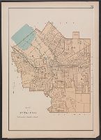
From: Atlas of the state of New York. New York : Julius Bien & Co., 1895. and Shows streets, railroads, canals, wards, parks, cemeteries, major buildings, etc.
Publisher:
Julius Bien & Co.,
Subject (Geographic):
Syracuse (N.Y.)--Maps
Subject (Name):
Bien, Joseph R. Atlas of the state of New York and Julius Bien & Co
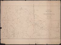
Geological and Geographical Survey of the Territories (U.S.)
Published / Created:
1879
Call Number:
80cbj 1879
Container / Volume:
BRBL_00537
Image Count:
1
Resource Type:
Maps, Atlases & Globes
Description:
Relief shown by hachures and spot heights.
Publisher:
the Survey,
Subject (Geographic):
Green River Watershed (Wyo.-Utah)--Maps
Subject (Name):
Bechler, G. R, Chittenden, George B, Clark, Fred A, Gannett, Henry, 1846-1914, Hayden, F. V. (Ferdinand Vandeveer), 1829-1887, Julius Bien & Co, and Wilson, A. D. (Allen D.)
Subject (Topic):
Watersheds--Idaho--Maps, Watersheds--Utah--Maps, and Watersheds--Wyoming--Maps
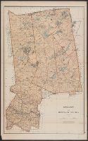
"Copyright 1895, Julius Bien & Company N.Y.", From: Atlas of the state of New York. New York : Julius Bien & Co., 1895., Maps prepared by Joseph Bien., Relief shown by hachures and spot heights., and Shows roads, railroads, settlements, original patents, towns, e
Publisher:
Julius Bien & Co.,
Subject (Geographic):
Hamilton County (N.Y.)--Maps and Herkimer County (N.Y.)--Maps
Subject (Name):
Bien, Joseph R. Atlas of the state of New York and Julius Bien & Co
Subject (Topic):
Land grants--New York (State)--Hamilton County--Maps and Land grants--New York (State)--Herkimer County--Maps
Preliminary agricultural map of Colville region, Washington Terr., Preliminary agricultural map of Yakima Region., and Soils of the Yakima and Colville regions.
Description:
Accompanied by text: Soils of the Yakima and Colville regions (1 leaf ; 61 cm.), Cover title., Preliminary agricultural map of Yakima Region -- Preliminary agricultural map of Colville region, Washington Terr., Raphael Pumpelly, director., and Relief shown by contours, spot heights, and hachures.
Publisher:
Julius Bien & Co.,
Subject (Name):
Hilgard, Eugene W. (Eugene Woldemar), 1833-1916, Julius Bien & Co, and Pumpelly, Raphael, 1837-1923