Homann Erben (Firm) Homann, Johann Baptist, 1663-1724
Published / Created:
ca. 1730]
Call Number:
319 1720
Container / Volume:
BRBL_00040
Image Count:
1
Resource Type:
Maps, Atlases & Globes
Alternative Title:
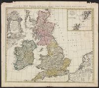
General map of Great Britain and Ireland with part of Holland, Flanders France &c. agreable to modern history by the heirs of late Mr. Homann at Nuremburg
Description:
Graphic scales given in "mill. Anglica" and "milliaria Germ.", Inset, top right: Orcades insulae ... Schetlandicae., Ornate title cartouche, top left, depicting coat of arms and flags., Relief shown pictorially., and Sheet measures 54.5 x 61.9 cm.
Publisher:
Homann Erben,
Subject (Geographic):
Great Britain--Maps--Early works to 1800 and Ireland--Maps--Early works to 1800
Carte generale de la Tartarie chinoise et des royaumes de Corée et de Iapan
Description:
French alternate title only., Imperfect: western sheet (with cartouche) wanting. Sheet measures 54 x 54 cm, with watermark., Includes text and ill., and Relief shown pictorially.
Publisher:
Curis Homannianorum Heredum,
Subject (Geographic):
Chine--Divisions politiques et administratives--Cartes--Ouvrages avant 1800. and Manchuria (China)--Maps--Early works to 1800.
Subject (Name):
Anville, Jean Baptiste Bourguignon d', 1697-1782., Du Halde, J.-B. (Jean-Baptiste), 1674-1743., Gerbillon, Jean-François, 1654-1707., Homann Erben (Firm), and Mayer, Tobias, 1723-1762.
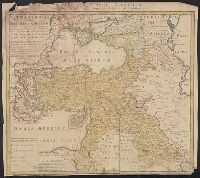
Appears in: Städt-atlas oder Schäuplatz berühmter Städte: Vestungen, Prospekte, Gegenden, Grundrisse, Belagergungen, etc. Nürnberg : Homännischen Erben, 1762., Insets: Landau; Strasburg; Neu Breisach; Fort Louis; Hünningen; Manheim; Philippsburg; Alt Breisach; Freiburg., Manuscript number in lower right corner: 40. From the Karpinski-von Wieser Map Collection., and Relief shown pictorially.
Publisher:
[Homann Erben]
Subject (Geographic):
Baden-Württemberg (Germany)--Maps--Early works to 1800.
Subject (Topic):
Polish Succession, War of, 1733-1738--Maps--Early works to 1800.
Carte de la Turquie Asiatique contenant la Natolie Moderne divisée en fes Beglerbeys &.
Description:
"C.P.S.C.M.", Bar scales given in "milliaria Germanica," "milliaria Turcica terrestria," and "milliaria Turcica marina"., Imperfect: chewed at edges, witn some loss of text. Sheet measures 48.6 x 54.7 cm., Prime meridian: Ferro., Relief shown pictorially., and Wat
Publisher:
Impensis Homannianorum Heredum,
Subject (Geographic):
Middle East--Maps--Early works to 1800 and Turkey--Maps--Early works to 1800