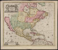
Appears in various eds. of Atlas geographicus maior., Includes German text relating to English and French territorial claims., Mounted on paper. Neat line measures 45.9 x 51 cm. on sheet 46 x 51.2 cm. Ms. no.: 54., and Place names and descriptive notes in Englis
Publisher:
[Homann Erben],
Subject (Geographic):
North America--Maps--Early works to 1800 and United States--History--French and Indian War, 1755-1763--Maps--Early works to 1800
Subject (Name):
Anville, Jean Baptiste Bourguignon d', 1697-1782 and Homann Erben (Firm). Atlas geographicus maior
Appears in various eds. of Atlas geographicus maior., Includes German text relating to English and French territorial claims., Place names and descriptive notes in English., Prime meridian: Ferro and London., Relief shown pictorially., and Sheet measures 47.1 x 52 cm. Ms. no. on verso: No. 5. Cross Collection no. 194.
Publisher:
[Homann Erben],
Subject (Geographic):
North America--Maps--Early works to 1800 and United States--History--French and Indian War, 1755-1763--Maps--Early works to 1800
Subject (Name):
Anville, Jean Baptiste Bourguignon d', 1697-1782 and Homann Erben (Firm). Atlas geographicus maior
Appears in various eds. of Atlas geographicus maior., Includes German text relating to English and French territorial claims., Place names and descriptive notes in English., Prime meridian: Ferro and London., Relief shown pictorially., and Sheet measures 49.5 x 61.7 cm. Title in ms. on verso. Franklin Collection no. 131 1777-1.
Publisher:
[s.n.],
Subject (Geographic):
North America--Maps--Early works to 1800 and United States--History--French and Indian War, 1755-1763--Maps--Early works to 1800
Subject (Name):
Anville, Jean Baptiste Bourguignon d', 1697-1782 and Homann Erben (Firm). Atlas geographicus maior
Appears in various eds. of Atlas geographicus maior., Includes German text relating to English and French territorial claims., Place names and descriptive notes in English., Prime meridian: Ferro and London., and Relief shown pictorially.
Publisher:
[s.n.],
Subject (Geographic):
North America--Maps--Early works to 1800. and United States--History--French and Indian War, 1755-1763--Maps--Early works to 1800.
Subject (Name):
Anville, Jean Baptiste Bourguignon d', 1697-1782. and Homann Erben (Firm). Atlas geographicus maior.
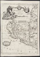
From Jansonius's and Hondius's Atlas novus ... Amstelodami : Apud Ionnem Ianssonium & Henricum Hondium, 1638., Hand col. Mounted on linen. Sheet measures 50.6 x 58.4 cm. Cross collection no., Latin text on verso; with signature 4O., and Relief shown pictorially.
Publisher:
s.n.,
Subject (Geographic):
North America--Maps--Early works to 1800
Subject (Name):
Hondius, Hendrik, 1597-1651. Atlas novus and Jansson, Jan, 1588-1664. Atlas novus
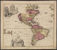
Covers North America, Cent, Dutch text on verso, with signature "Bb.", Relief shown pictorially., and State 2, first issued in 1641, according to Burden; matches description of Dutch text versions appearing in Nieuwen atlas editions 1645, '47, '52, '53, and '58.
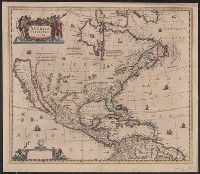
Covers Nort, Library's copy stamped on verso: Yale, Horace Brown, 1900S., Relief shown pictorially., and State 2, first issued in 1641, according to Burden; matches description of variant with Latin text appearing in Novus atlas editions 1647, '49, '56, and '58.
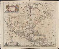
Hand col. Sheet measures 51 x 60 cm. Stamp on verso: Horace Brown 1900S., Includes ill. and text., Relief shown pictorially., Shows California as an island and boundaries as dotted lines., and State 3, issued ca. 1694, according to Burden.
Appears in his Atlante veneto ... Venetia : a' spese dell' autore, 1695-1697., Prime meridian: Ferro., Relief shown pictorially., and Yale's copy 2 missing western sheet; also stamped "Yale, Horace Brown, 1900S." dgvmp2008.