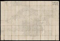
Also shows Amerindian reservations: Cayuga Reservation -- Onondago Reservation -- Oneida Reservation., Imperfect: mutilated. Backed with paper., Includes note describing the numbering of military-township lots., and Shows property tract boundaries, town (militar
Publisher:
[publisher not identified],
Subject (Geographic):
New York (State)--Administrative and political divisions--Maps--Early works to 1800, New York (State)--Upstate New York, and Upstate New York (N.Y.)--Administrative and political divisions--Maps--Early works to 1800
Subject (Name):
Tiebout, Cornelius, 1777-1832
Subject (Topic):
Administrative and political divisions, Indian reservations--New York (State)--Maps--Early works to 1800., Landowners--New York (State)--Maps--Early works to 1800., and Landowners--New York (State)--Upstate New York--Maps--Ear
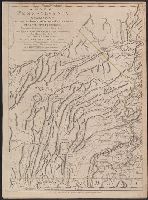
Imprint in three places along lower left, center, and right margin., Prime meridian: London. "Longitude west from London.", Relief shown by shading and hachures., Revolutionary War era map of Pennsylvania, compiled by Sayer & Bennett, primarily from William Schull's map. The detailed map extending from Fort Pitt (formerly Fort Duquesne) in the west to the New Jersey border along the Delaware river to the east., Scale of "English Miles 69 1/2 to a Degree"., Separately published and in editions of "The North American Atlas" published by Faden; and Thomas Jefferys' The American atlas. 1775;, and Shows counties, townships, towns and cities, Indian villages, stores, churches, taverns, and names of residents in the countryside; rivers and streams, waterfalls, ferries, swamps, springs, and landmarks; mills, mines, furnaces, and forges; and forts and French and Indian War battle sites. - Cf. Seller & Van Ee, Maps and charts of North America and West Indies, 1750-1789, entry 1296.
Publisher:
Printed for Robt. Sayer & J. Bennett, map & printseller No. 53 in Fleet Street. Published as the Act directs,
Subject (Geographic):
Pennsylvania--Administrative and political divisions--Maps--Early works to 1800. and Pennsylvania--Maps--Early works to 1800.
Subject (Name):
Penn, Richard, 1706-1771, dedicatee., Penn, Thomas, 1702-1775, dedicatee., and Robert Sayer and John Bennett (Firm), publisher, printseller.
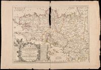
Hand colored. Stamp: Karpinski-von Wieser Map Collection. and Includes notes, explanation of scales and an "Avertissement".
Publisher:
Chez J.B. Nolin, sur le Quay de l'Horloge du Palais a l'Enseigne de la Place des Victoires, Vers le Pont Neuf, Avec Privilege du Roy,
Subject (Geographic):
Brittany (France)--Administrative and political divisions--Maps--Early works to 1800., Brittany (France)--Maps--Early works to 1800., and France--Brittany
Mitchell, S. Augustus (Samuel Augustus), 1792-1868
Published / Created:
1843
Call Number:
771 1843
Container / Volume:
BRBL_00478
Image Count:
1
Resource Type:
Maps, Atlases & Globes
Alternative Title:
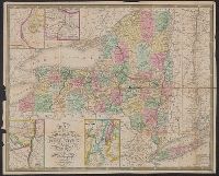
New-York
Description:
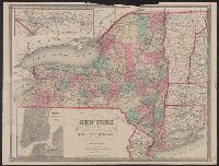
"Sold by Thomas, Cowperthwait & Co. ...", Hand colored., Insets: Vicinity of the Falls of Niagara -- Vicinity of Rochester -- Vicinity of Albany -- Vicinity of New York -- Map of the Hudson River from New York to Albany., Relief shown pictorially., and Shows coun
Publisher:
S. Augustus Mitchell,
Subject (Geographic):
New York (State), New York (State)--Administrative and political divisions--Maps., and New York (State)--Maps
Also covers Vermont, Connecticut, and part of New Jersey, New Hampshire & Massachusetts., Includes legend., Insets: The St. Lawrence River, from the New York state line to Quebec -- City of New York, with part of Brooklyn and Williamsburgh., and Prime meridians:
Publisher:
J. Disturnell,
Subject (Geographic):
New York (State), New York (State)--Administrative and political divisions--Maps., and New York (State)--Maps.
Subject (Name):
Disturnell, John, 1801-1877 and Sherman & Smith
Subject (Topic):
Administrative and political divisions, Canals, Canals--New York (State)--Maps., Railroads, and Railroads--New York (State)--Maps.
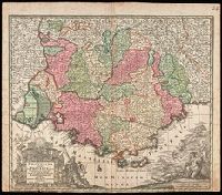
"Cum Gratia et Privil. S.R.I. Vicariatus in partibus Rheni, Sveviae et juris Franconici.", Ornamental cartouche decorated with coats of arms and mythical figures., Relief shown pictorially., and Watermark. Manuscript number in right corner: 24. From the Karpinski-von Wieser Map Collection.
Publisher:
[Mattheus Seutter]
Subject (Geographic):
France--Provence-Alpes-Côte d'Azur, Provence-Alpes-Côte d'Azur (France)--Administrative and political divisions--Maps--Early works to 1800., and Provence-Alpes-Côte d'Azur (France)--Maps--Early works to 1800.
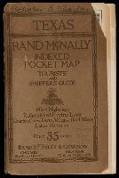
Indexed pocket map, tourists' and shippers' guide of Texas, Texas, Rand McNally indexed pocket map, tourists' and shippers' guide, Rand McNally standard map of Texas, Standard map of Texas, Rand McNally new commercial atlas map of Texas, and New commercial atlas map of Texas
Description:
BEIN Covers 796 1921: Original wrappers. Inscription on front cover: Malcolm R. Thorpe., Relief shown by hachures and spot heights., Shows railroads and counties., Title from index., Includes insets of the panhandle and southern Texas, and indexes., and On verso: Rand McNally main highway map of Texas. Scale [ca. 1:1,267,200].
Publisher:
Rand McNally
Subject (Geographic):
Texas and Texas Panhandle (Tex.)
Subject (Topic):
Administrative and political divisions and Railroads