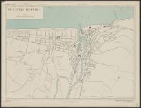
France 1:5,800, Geographical Section, General Staff ; no. 4234, and GSGS (Series) ; 4234.
Description:
"1-44, 1944.", "First G.S.G.S. edition, 1943.", "Grid provisional, Nord de Guerre zone grid.", "War Office, 1943.", and Important streets and buildings are named.
Publisher:
Army Map Service, U.S. Army, and War Office ;
Subject (Geographic):
Deauville (France)--Maps and Trouville-sur-Mer (France)--Maps
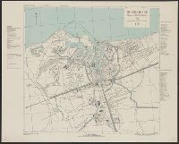
France 1:4,000, Geographical Section, General Staff ; no. 4234, and GSGS (Series) ; 4234.
Description:
"1-44.", "AMS 1.", "Grid provisional, Lambert zone I grid.", "War Office 1943.", A few important streets and buildings are named; areas exposed at low tide are indicated., Major street names and buildings in French., and Relief show by rock drawings.
Publisher:
Army Map Service, U.S. Army, and War Office ;
Subject (Geographic):
Douarnenez (France)--Maps and Tréboul (France)--Maps
France 1:10,000, Geographical Section, General Staff ; no. 4234, and GSGS (Series) ; 4234.
Description:
"8-43.", "AMS 2.", "Grid provisional, Nord de Guerre zone grid.", "War Office 1943.", Important streets are named; list of important buildings, industries and port facilities in margin., and Major streets and buildings in French.
France 1:5,000, Geographical Section, General Staff ; no. 4234, and GSGS (Series) ; 4234.
Description:
"1-44.", "First G.S.G.S. ed., 1943.", "Grid provisional. Nord de Guerre zone grid.", "War Office 1943.", Important street names, industries and port facilities are shown., Includes index., Major street names, some buildings, and sites in French., and Relief shown by
Great Britain. War Office. General Staff. Geographical Section
Published / Created:
1943
Call Number:
38 L562 1943
Container / Volume:
BRBL_00158
Image Count:
1
Resource Type:
Maps, Atlases & Globes
Alternative Title:
France 1:4,000, Geographical Section, General Staff ; no. 4234, and GSGS (Series) ; 4234.
Description:
"2nd edition, 1943.", "6-43.", "Air photographs have been used in the production of this plan.", "Grid provisional, Nord de guerre grid.", "Published by War Office, 1943.", Important streets and buildings are named., and Relief shown by rock drawings.
Great Britain. War Office. General Staff. Geographical Section
Published / Created:
1942, 1943 printing.
Call Number:
331gm 1943
Container / Volume:
BRBL_00080
Image Count:
1
Resource Type:
Maps, Atlases & Globes
Alternative Title:
Geographical Section, General Staff ; no. 4183 and GSGS (Series) ; 4183.
Description:
"5-43.", "6/42/G.S.G.S.", "N5047-E402/239x309.", "War Office, 1942.", Five classes of railroads with various traffic facilities, and navigable canals and rivers are shown., and Includes inset maps: Continuation west -- Amsterdam -- Rotterdam -- Antwerp.
Publisher:
Army Map Service, U.S. Army, and War Office ;
Subject (Topic):
Nautical charts--Netherlands, Railroads--Netherlands--Maps, and Waterways--Netherlands--Maps
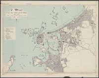
France 1:7,350, Geographical Section, General Staff ; no. 4234, GSGS (Series) ; 4234., and Royan, plan of town
Description:
"First A.M.S. ed., 1943.", "First G.S.G.S. ed., 1943.", "Grid provisional. Lambert (zone II) grid.", "I-44.", "War Office 1943.", Important streets are named; key to points of interest in margin., and Major street names and some buildings in French.
France 1:6,000, Geographical Section, General Staff ; no. 4234, GSGS (Series) ; 4234., Saint Malo, and St. Malo, plan of port and town
Description:
"G.S.G.S. edition, 1943.", "Grid provisional. Lambert zone I grid.", "I-44.", "War Office, 1943.", Principal street names, important buildings and port facilities are indicated., Relief shown by rock drawings., and Street names and some places of interest in French
Great Britain. War Office. General Staff. Geographical Section
Published / Created:
1943
Call Number:
38 C42 1943
Container / Volume:
BRBL_00156
Image Count:
1
Resource Type:
Maps, Atlases & Globes
Alternative Title:
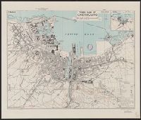
Geographical Section, General Staff ; no. 4234 and GSGS (Series) ; 4234.
Description:
"3rd edition 1943.", "Air photographs have been used in the production of this plan.", "Contours at 10 metres interval.", "N4937.4-W134.5/2.5x5.", "Published by War Office, 1941.", Important streets and buildings are named., and Includes inset map: Environs of Cher
Publisher:
[Printed by] Army Map Service, U.S. Army, and Published by War Office ;