Skip to search
Skip to main content
Skip to first result
Search
You Searched For
Creator
Wyld, James, 1812-1887
Publication Place
London :
New Search
Search Results
Creator:
Published / Created:
[1861?]
Call Number:
75 1861F
Container / Volume:
BRBL_00402
Image Count:
2
Resource Type:
Maps, Atlases & Globes
Alternative Title:
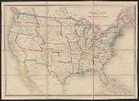
Relative position of the northern states and the southern confederated states and United States and the relative position of the northern states and the southern confederated states
Description:
Accompanying covers with title: Wyld's new map of the United States., Includes tables of population statistics for the "free states" and the "slave states", exports, presidential voting statistics, and real and personal property in both the, and Outline color.
Publisher:
James Wyld,
Subject (Geographic):
United States--History--Civil War, 1861-1865--Maps
Subject (Topic):
Confederate States of America--History--Civil War, 1861-1865--Maps
Found in:
Beinecke Rare Book and Manuscript Library > The United States & the relative position of the Northern states and the Southern Confederated states / by James Wyld, Charing Cross East.
Creator:
Published / Created:
[1870?]
Call Number:
75 1870B
Container / Volume:
BRBL_00404
Image Count:
1
Resource Type:
Maps, Atlases & Globes
Alternative Title:
United States and the relative position of the Oregon and Texas
Description:
In lower right margin: 37., Inset: England, Wales & Scotland -- same scale., and Map of the United States. Relief shown by hachures.
Publisher:
Published by Jas. Wyld, Geographer to the Queen & H.R.H. Prince Albert, Charing Cross East,
Subject (Geographic):
United States--Maps
Found in:
Beinecke Rare Book and Manuscript Library > The United States & the relative position of the Oregon & Texas / by James Wyld, Charing Cross East.
Creator:
Published / Created:
[1857]
Call Number:
75 1857A
Container / Volume:
BRBL_00401
Image Count:
1
Resource Type:
Maps, Atlases & Globes
Alternative Title:
United States and the relative position of the Oregon and Texas
Description:
Inset: Great Britain, on the same scale. and Map of the United States. Relief shown by hachures.
Publisher:
Jas. Wyld,
Subject (Geographic):
United States--Maps
Found in:
Beinecke Rare Book and Manuscript Library > The United States & the relative position of the Oregon & Texas / by James Wyld, Charing Cross East.
Creator:
Published / Created:
[1851?]
Call Number:
23 1851
Container / Volume:
BRBL_00020
Image Count:
1
Resource Type:
Maps, Atlases & Globes
Publisher:
J. Wyld,
Subject (Geographic):
Pacific Ocean--Maps
Found in:
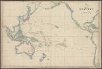
Beinecke Rare Book and Manuscript Library > The basin of the Pacific / Jas. Wyld.
Creator:
Published / Created:
March 31st 1855.
Call Number:
35311hc Se21 1855
Container / Volume:
BRBL_00112
Image Count:
1
Resource Type:
Maps, Atlases & Globes
Alternative Title:
Siege of Sevastopol and The environs of Sevastopol with the batteries & approaches
Description:
Composite map showing the placement of English, French, Turkish and Russian troops, batteries and encampments., Includes list of Wyld's new publications., Inset: Eupatoria with the attack of 17th Feby. 1855., and Relief shown by land form drawings. Depths shown
Publisher:
Published by James Wyld ... Charing Cross East & 2 Royal Exchange,
Subject (Geographic):
Sevastopolʹ (Ukraine)--History--Siege, 1854-1855--Maps
Subject (Topic):
Crimean War, 1853-1856--Campaigns--Ukraine--Maps
Found in:
Beinecke Rare Book and Manuscript Library > The environs of Sevastopol with the batteries and approaches / by James Wyld.
Creator:
Published / Created:
1851
Call Number:
8555 1851
Container / Volume:
BRBL_00642
Image Count:
2
Resource Type:
Maps, Atlases & Globes
Alternative Title:
Jamaica
Description:
" ... published ... Feby. 28th, 1851.", Advertisement mounted on verso., Includes statistical data., and Relief shown by hachures and spot heights.
Publisher:
Published by J. Wyld,
Subject (Geographic):
Jamaica--Maps
Found in:
Beinecke Rare Book and Manuscript Library > The island of Jamaica / by James Wyld, geographer to the Queen and H.R.H. Prince Albert.
Creator:
Published / Created:
[ca. 1880]
Call Number:
32 L84 1880B
Container / Volume:
BRBL_00051
Image Count:
1
Resource Type:
Maps, Atlases & Globes
Alternative Title:
Plan of London
Description:
Shows names of streets, urban boroughs boundaries, roads & proposed roads, railroads, drainage, & other points of interest.
Publisher:
Published by Jas. Wyld, Charing Cross, East,
Subject (Geographic):
London (England)--Maps
Subject (Topic):
Postal services--England--London--Maps and Streets--England--London--Maps
Found in:
Beinecke Rare Book and Manuscript Library > The post office plan of London [map] / engraved by Jas. Wyld, geographer to the Queen ...
Creator:
Published / Created:
[186-?]
Call Number:
267 1865
Container / Volume:
BRBL_00023
Image Count:
1
Resource Type:
Maps, Atlases & Globes
Description:
Insets: Plan of the entrance to Port Manoukao -- Plan of Victoria Bay of Islands New Zealand -- Port Nicholson -- Plan of Dusky Bay -- Plan of Southern Port, Stewarts Island -- -Oyerri or Pelorus River -- Plan of the bar and part of the Hokianga River . and Plan of Port Nicholson and Oyerri by permission of the New Zealand Land Company.
Publisher:
James Wyld, geographer to the Queen, Charing Cross East,
Subject (Geographic):
New Zealand--Maps
Subject (Name):
New Zealand Company
Found in:
Beinecke Rare Book and Manuscript Library > To the Right Honourable the Secretary of State for the Colonies &c. This chart of New Zealand from original surveys / engraved by Jas. Wyld, Charing Cross East.
Creator:
Published / Created:
1873
Call Number:
6555 1873
Container / Volume:
BRBL_00346
Image Count:
1
Resource Type:
Maps, Atlases & Globes
Description:
At head of sheet: "Wylds Military Map". and Insets: Enlarged map [of the route from Coomassie to Anamaboe and Cape Coast Castle; Location maps of Africa and West Africa].
Publisher:
James Wyld,
Subject (Geographic):
Ashanti Region (Ghana)--Maps
Found in:
Beinecke Rare Book and Manuscript Library > Wyld's Map of Ashanti : and neighbouring states with the British Possessions on the Gold Coast / published by James Wyld, Geographer to the Queen, 457 Strand, 11 & 12 Charing Cross & 2 Royal Exchange, London, November 20, 1873.
Creator:
Published / Created:
[1875?]
Call Number:
60 1875
Container / Volume:
BRBL_00327
Image Count:
1
Resource Type:
Maps, Atlases & Globes
Alternative Title:
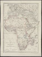
Africa, Map shewing the various explorations in Africa, and Wyld's map showing the various explorations in Africa
Description:
Relief shown by hachures.
Publisher:
J. Wyld,
Subject (Geographic):
Africa--Discovery and exploration--Maps
Found in:
Beinecke Rare Book and Manuscript Library > Wyld's map shewing the various explorations in Africa / James Wyld.
Branch:v1.61.8 ,Deployed:2024-06-20T11:14:55-04:00