Search
You Searched For
Search Results
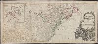
- Creator:
- Pownall, Thomas, 1722-1805
- Published / Created:
- 1794 May 12
- Call Number:
- 71 1794
- Container / Volume:
- BRBL_00367
- Image Count:
- 2
- Resource Type:
- Maps, Atlases & Globes
- Found in:
- Beinecke Rare Book and Manuscript Library > A new map of North America with the West India Islands : divided according to the preliminary articles of peace, signed at Versailles, 20 Jan. 1783, wherein are particularly distinguished the United States, and the several provinces, governments &ca which
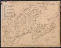
- Creator:
- Pownall, Thomas, 1722-1805
- Published / Created:
- 1794 May 12
- Call Number:
- 71 1794
- Container / Volume:
- BRBL_00367
- Image Count:
- 1
- Resource Type:
- Maps, Atlases & Globes
- Found in:
- Beinecke Rare Book and Manuscript Library > A new map of North America with the West India Islands : divided according to the preliminary articles of peace, signed at Versailles, 20 Jan. 1783, wherein are particularly distinguished the United States, and the several provinces, governments &ca which
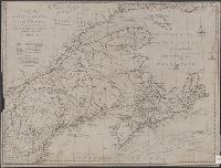
- Published / Created:
- 1783
- Call Number:
- 71 1783P
- Container / Volume:
- BRBL_00726
- Image Count:
- 2
- Resource Type:
- Maps, Atlases & Globes
- Found in:
- Beinecke Rare Book and Manuscript Library > A new map of North America, with the West India islands ... laid down according to the latest surveys, and corrected from the original materials, of Goverr. Pownall.
- Published / Created:
- 1786
- Call Number:
- 755 1786
- Container / Volume:
- BRBL_00435
- Image Count:
- 1
- Resource Type:
- Maps, Atlases & Globes
- Found in:
- Beinecke Rare Book and Manuscript Library > A new map of Nova Scotia and Cape Breton Island with the adjacent parts of New England and Canada ...
- Creator:
- Cary, John, ca. 1754-1835
- Published / Created:
- April 28 1811.
- Call Number:
- 732 1811
- Container / Volume:
- BRBL_00376A
- Image Count:
- 1
- Resource Type:
- Maps, Atlases & Globes
- Found in:
- Beinecke Rare Book and Manuscript Library > A new map of Nova Scotia, Newfoundland &c., from the latest authorities / by John Cary, engraver.
- Creator:
- Jefferys, Thomas, -1771
- Published / Created:
- 15 June 1775.
- Call Number:
- 732 1775
- Container / Volume:
- BRBL_00727
- Image Count:
- 1
- Resource Type:
- Maps, Atlases & Globes
- Found in:
- Beinecke Rare Book and Manuscript Library > A new map of Nova Scotia, and Cape Breton Island : with the adjacent parts of New England and Canada, composed from a great number of actual surveys; and other materials regulated by many new astronomical observations of the longitude as well as latitude
- Creator:
- Lodge, John, -1796
- Published / Created:
- 31st July 1785.
- Call Number:
- 732 1785
- Container / Volume:
- BRBL_00376A
- Image Count:
- 1
- Resource Type:
- Maps, Atlases & Globes
- Found in:
- Beinecke Rare Book and Manuscript Library > A new map of Nova Scotia, and Cape Britain [cartographic material] : With the adjacent parts of New England and Canada, from the latest authorities / J. Lodge sc.
- Published / Created:
- 1811
- Call Number:
- 534 1811A
- Container / Volume:
- BRBL_00289
- Image Count:
- 1
- Resource Type:
- Maps, Atlases & Globes
- Found in:
- Beinecke Rare Book and Manuscript Library > A new map of Persia ... By John Cary, Engraver.
- Creator:
- Cary, John, approximately 1754-1835, cartographer
- Published / Created:
- Augst. 1. 1799.
- Call Number:
- 401 1799
- Container / Volume:
- BRBL_00233
- Image Count:
- 1
- Resource Type:
- Maps, Atlases & Globes
- Found in:
- Beinecke Rare Book and Manuscript Library > A new map of Piedmont, the duchies of Savoy and Milan, and the republic of Genoa, with their subdivisions : from the latest authorities / by John Cary.
- Published / Created:
- 1811
- Call Number:
- 356 1772-1811
- Container / Volume:
- BRBL_00113
- Image Count:
- 1
- Resource Type:
- Maps, Atlases & Globes
- Found in:
- Beinecke Rare Book and Manuscript Library > A new map of Poland and the Grand Duchy of Lithuania ... between Austria, Russia, and Prussia in 1772, 1793, & 1795 ... By John Cary, Engraver. 1811.