"Privilegio Imperiali, Regio, et Belgico decennali, 1586.", Appears in the author's Theatrum orbis terrarum. 1595., Dedicated to Iohannes Moflinius by Abraham Ortelius., and Includes ill. in medallions surrounding map depicting scenes from Abraham's life and ins
Publisher:
Officina Plantiniana,
Subject (Geographic):
Palestine--History--Maps--Early works to 1800
Subject (Name):
Abraham--(Biblical patriarch), Abraham--(Biblical patriarch)--Travel--Maps--Early works to 1800, Moflinius, Iohannes, and Ortelius, Abraham, 1527-1598. Theatrum orbis terrarum
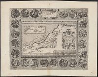
Along sides and bottom: 16 vignettes of biblical objects., Includes plan of the Temple in the left bottom corner and view of the Temple in the right bottom corner., Inset: oval map of ancient Jerusalem, "Hierosolymae veteris imago.", and Oriented with north to t
Publisher:
Martinus Nutius,
Subject (Geographic):
Jerusalem--Maps--Early works to 1800 and Palestine--Maps--Early works to 1800
Anville, Jean Baptiste Bourguignon d', 1697-1782, cartographer
Published / Created:
[1767]
Call Number:
50 1767
Container / Volume:
BRBL_00271
Image Count:
1
Resource Type:
Maps, Atlases & Globes
Description:
Cartographer and publication date from dealer's notes., Country labels in French., Inset: Supplement pour l'Asie et l'Afrique., Relief shown pictorially., Shows most of the Middle East, and part of Egypt., Stamp on verso: 27., and Watermark.
Publisher:
[publisher not identified],
Subject (Geographic):
Middle East--Maps--Early works to 1800, Palestine--History--To 70 A.D.--Maps--Early works to 1800, and Palestine--Maps--Early works to 1800
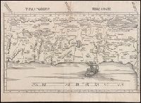
Coordinates approximate and based on Greenwich meridian., Descriptive text throughout., From Ptolemy's Geographia (1513)., Latitudinal and longitudinal lines., North oriented towards the left., Relief shown pictorially., Shows topography, drainage, territories of the tribes of Israel, travel routes, places of historical interest., and Watermark.
Publisher:
[Martin Waldseemüller],
Subject (Geographic):
Palestine--Maps--Early works to 1800.
Subject (Name):
Ptolemy, active 2nd century. Geographia.
Subject (Topic):
Bible--Geography--Maps--Early works to 1800, Christianity--Palestine--Maps--Early works to 1800., and Twelve tribes of Israel--Maps--Early works to 1800.