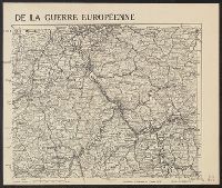
"G. Peltier, Paris" in bottom right corner of map., "Supplément à l'illustration du Janvier 1915.", and Shows railways, roads, canals, borders, and fortifications.
Appears in G. Desprez' and Jean Desessartz' La Sainte Bible en latin et françois. 1717., Has watermark., In top left margin: Carte troisième., Includes ornamental cartouche and ill., and Relief shown pictorially.
Publisher:
Chez Guillaume Desprez ... et Jean Desessartz, rue S. Jacques, à l'Enseigne de S. Prosper et des tres Vertus,
Subject (Geographic):
Palestine--History--To 70 A.D.--Maps and Palestine--Maps--Early works to 1800
Subject (Name):
Delamonce, Ferdinand, 1678-1753, Desessartz, Jean, Desprez, Guillaume, and Scotin, G
Subject (Topic):
Bible.--O.T.--Geography--Maps, Jews--History--To 586 B.C.--Maps, and Twelve tribes of Israel--Maps--Early works to 1800
Voyage autour du monde par la frégate du Roi la Boudeuse, et la flûte l'Etoile, en 1766, 1767, 1768
Image Count:
1
Resource Type:
Maps, Atlases & Globes
Description:
In French., In upper right margin: Pl. 1., Plate 1 from: Voyage autour du monde : par la frégate du Roi la Boudeuse, et la flûte l'Etoile, en 1766, 1767, 1768, & 1769 / [by Louis Antoine de Bougainville]., Prime meridian: Paris., Watermark., and World map showing route of the Boudeuse and the Etoile. Australia named as Nouvelle Hollande with incomplete coastline and Tasmania named as Terre de Dieman with a portion of incomplete coastline. West coast of Australia mapped. Australia appears conjoined to New Guinea.
Publisher:
[De l'imprimerie de Le Breton ...],
Subject (Name):
Boudeuse (Frigate), Bougainville, Louis-Antoine de, comte, 1729-1811. Voyage autour du monde : par la frégate du Roi la Boudeuse, et la flûte l'Etoile, en 1766, 1767, 1768, & 1769., Etoile (Ship), and Saillant & Nyon.
Subject (Topic):
Voyages around the world--Early works to 1800. and World maps.
"Imprimerie xincographique du Service géographique de l'armée.", Includes key map., Relief shown by contours and shading., and Shows administrative boundaries, railways, roads, principal buildings named.
"Mai 1904.", Relief shown by shading and spot heights. Depths shown by soundings and bathymetric contours., and Shows Guandong Peninsula, southern Liaoning Sheng.
Publisher:
Service géographique de l'Armée,
Subject (Geographic):
Dalian Region (China)--Maps and Lüshun Region (China)--Maps
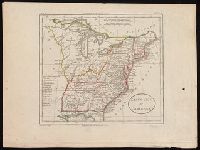
From William Guthrie's Atlas universel (1802)., In upper left corner: Atl. p. 25., In upper right corner: Atl. Un. 34., Prime meridians: Ferro and Paris., and Relief shown pictorially.
Publisher:
[H. Langlois],
Subject (Geographic):
East (U.S.)--Maps--Early works to 1800.
Subject (Name):
Blondeau, active 18th century-19th century and Guthrie, William, 1708-1770. Atlas universel.
Aureum contra impudice scribentes opusculum, Contra impudice scribentes opusculum, Contra poetas impudice loquentes, F. Baptiste Matuani Carmelite theologi, Aureum contra impudice scribentes opusculum, and Fratris Baptist[a]e Ma[n]tuani Carmelit[a]e theologi, Aureum contra impudice scribentes opusculum
Description:
Commentary by Jodocus Badius Ascensius., Imprint from colophon. Georges Wolf named as additional printer in Proctor, GW, Goff, and ISTC (RLIN)., Includes index., Marginal ms. annotations. Bound with a contemporary ms.: De Orgiis corporis Christi, Signatures: 2A⁸ 2B-2C⁶., and Verso of final leaf blank.
Publisher:
Impressum ... Thielma[n]ni Keruer Teutonis, expensis ... Ioa[n]nis Co[n]flue[n]tini & Ioan[n]is Pusilli, id est ... pour M. Hanse de Coblencz ... & Iehan Petit ... a Paris,
Subject (Topic):
Incunabula in Yale Library and Poetry, Latin (Medieval and modern)
"Atlas universel, Vivien de Saint-Martin & Fr. Schrader." and Relief shown by gradient tints, hachures, and spot heights. Depths shown by bathymetric tints.
Publisher:
Librairie Hachette & compie,
Subject (Geographic):
France--Maps
Subject (Name):
Delaune, E, Dufrénoy (Firm), Dumas-Vorzet, Ed. (Eduard), Hachette (Firm), Schrader, Franz, 1844-1924, Vivien de Saint-Martin, M, and Weinreb, T
"Corrections essentialles en Juil. 1882.", Includes coordinates of lighthouse and elevation drawing as viewed from the NNE., and Shows fortifications, churches, and lighthouses.