Skip to search
Skip to main content
Skip to first result
Search
You Searched For
Date
1600 - 1699
Resource Type
Maps, Atlases & Globes
Date Created
1600 to 1699
New Search
Search Results
Creator:
Published / Created:
[169-?]
Call Number:
1973 Folio 10
Image Count:
1
Resource Type:
Maps, Atlases & Globes
Description:
Bar scales given in English and French leagues and Dutch miles., No. 6 of 69 maps bound together in composite atlas., and Scale [ca. 1:1 550 000].
Publisher:
Printed and sold by Chr. Brown at the Globe in St. Pauls Church Yard
Subject (Geographic):
England, Southern --Maps --Early works to 1800, English Channel --Maps --Early works to 1800, and France, Northern --Maps --Early works to 1800
Subject (Topic):
Coasts --England, Southern --Maps --Early works to 1800 and Coasts --France, Northern --Maps --Early works to 1800
Found in:
Beinecke Rare Book and Manuscript Library > A new chart of the sea coasts of France: together with the English Chanell describing ye severall harbors, sands, rocks, and anchoridges, etc. on the said coasts
Published / Created:
[1680?]
Call Number:
7855 1680
Container / Volume:
BRBL_00691
Image Count:
2
Resource Type:
Maps, Atlases & Globes
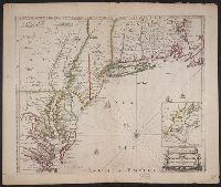
Description:
English on recto, verso., From John Speed's Theatre of the empire of Great Britain ... London : Printed for Thomas Basset ... and Richard Chiswel ..., 1676., Oriented west., Relief shown pictorially., Sheet measures 43.5 x 56. Cross Collection no. 219., and Verso: Page numbers "50", "49"; titles "The description of Carolina", "The description of Florida"; signature 2B.
Publisher:
Sold by Tho: Basset in Fleetstreet and Ric. Chiswell in St. Pauls Churchyard,
Subject (Geographic):
North Carolina--History--Colonial period, ca. 1600-1775--Maps--Early works to 1800, North Carolina--Maps--Early works to 1800, South Carol, and South Carolina--History--Colonial period, ca. 1600-1775--Maps--Early works to 1800
Subject (Name):
Bassett, Thomas, bookseller, Chiswell, Richard, Lamb, Francis, engraver, and Speed, John, 1552?-1629. Theatre of the Empire of Great Britaine
Found in:
Beinecke Rare Book and Manuscript Library > A new description of Carolina / Francis Lamb sculp.
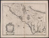
Published / Created:
1684?]
Call Number:
7855 1684
Container / Volume:
BRBL_00515
Image Count:
2
Resource Type:
Maps, Atlases & Globes
Description:
Insets: Ashley & Cooper River; settlements on this river.
Subject (Geographic):
North Carolina--Maps--Early works to 1800 and South Carolina--Maps--Early works to 1800
Found in:
Beinecke Rare Book and Manuscript Library > A new map of Carolina. By Philip Lea at the Atlas and hercules in Cheap Side.
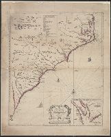
Published / Created:
[1690?]
Call Number:
755 1690
Container / Volume:
BRBL_00424
Image Count:
1
Resource Type:
Maps, Atlases & Globes
Description:
Inset: Environs of New York City. and Negative on file.
Publisher:
Philip Lea,
Subject (Geographic):
East (U.S.)--Maps--Early works to 1800
Found in:
Beinecke Rare Book and Manuscript Library > A new map of New England, New York, New Jarsey, Pensilvania, Maryland and Virginia.
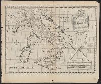
Published / Created:
[1660?]
Call Number:
40 1660
Container / Volume:
BRBL_00196
Image Count:
1
Resource Type:
Maps, Atlases & Globes
Subject (Geographic):
Italy--Maps--Early works to 1800
Found in:
Beinecke Rare Book and Manuscript Library > A new map of present Italy ... / Sutton Nicholls sculp.
Published / Created:
1680?]
Call Number:
39 1680
Image Count:
1
Resource Type:
Maps, Atlases & Globes
Alternative Title:
New map of present Spain & Portugal
Description:
Dedicated to ... William, Duke of Gloucester.
Subject (Geographic):
Portugal--Maps--Early works to 1800 and Spain--Maps--Early works to 1800
Found in:
Beinecke Rare Book and Manuscript Library > A new map of present Spain and Portugal : shewing their principal divisions, chief cities, townes, ports, rivers, mountains, &c. / R. Spofforth, sculp.
Published / Created:
[1673?]
Call Number:
32 1673
Container / Volume:
BRBL_00042
Image Count:
1
Resource Type:
Maps, Atlases & Globes
Description:
Views of cities of England border the map and various other data.
Subject (Geographic):
England--Maps--Early works to 1800
Found in:
Beinecke Rare Book and Manuscript Library > A new map of the Kingdome of England and Principality of Wales ... by John Overton ...
Published / Created:
[1690?]
Call Number:
326 1690
Container / Volume:
BRBL_00069
Image Count:
2
Resource Type:
Maps, Atlases & Globes
Subject (Geographic):
Scotland--Maps--Early works to 1800
Found in:
Beinecke Rare Book and Manuscript Library > A new map of the South part of Scotland. North part of Scotland. And: Johnston Delin: & Sculpt.
Creator:
Published / Created:
[168-?]
Call Number:
1973 Folio 10
Image Count:
1
Resource Type:
Maps, Atlases & Globes
Alternative Title:
New map of the estates of Savoy and Piedmont
Description:
Bar scales given in German miles, French miles, and English miles., No. 17 of 69 maps bound together in composite atlas., and Scale [ca. 1:620 000].
Publisher:
Sould by Robt. Morden at the Atlas in Cornhil and by Christ. Brown at the Globe in St. Pauls Church Yard
Subject (Geographic):
Savoy (France and Italy) --Maps --Early works to 1800
Found in:
Beinecke Rare Book and Manuscript Library > A new map of the estates of Savoy [and] Piedmont: with the countries adjacent
Creator:
Published / Created:
[1669]
Call Number:
71 1669
Container / Volume:
BRBL_00360
Image Count:
1
Resource Type:
Maps, Atlases & Globes
Description:
"To the Rt. Honble Anthony Earle of Shaftesbury Baron Ashley of Wimbourne St. Giles and Lord Cooper of Pawlet....", Has watermark., Includes decorative cartouche and ill., and Relief shown pictorially.
Publisher:
Printed for Richard Blome,
Subject (Geographic):
North America--Maps--Early works to 1800
Subject (Name):
Lamb, Francis and Sanson, Nicolas, 1600-1667
Found in:
Beinecke Rare Book and Manuscript Library > A new mapp of America Septentrionale / designed by Mousieur Sanson, geographer to the French King and rendred into English, and illustrated by Richard Blome by His Majesties especiall command ; Francis Lamb sculp.
Branch:v1.61.8 ,Deployed:2024-06-20T11:14:48-04:00