Skip to search
Skip to main content
Skip to first result
Search
You Searched For
Date
1500 - 1599
Resource Type
Maps, Atlases & Globes
Date Created
1500 to 1599
New Search
Search Results
Published / Created:
[1567]
Call Number:
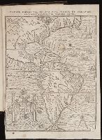
Peru Cwpr j567
Collection Title:
Levini Apollonii, Gandobrvgani, Mittelbvrgensis, de Peruuiae, regionis, inter Noui Orbis prouincias
Image Count:
1
Resource Type:
Maps, Atlases & Globes
Description:
Scale included.
Subject (Geographic):
Andes., Central America., Peru --History --Conquest, 1522-1548., and South America
Subject (Topic):
Discoveries in geography
Collection Created:
Antverpiae, Apud Ioannem Bellerum,
Found in:
Beinecke Rare Book and Manuscript Library > Brevis, exactaq totivs novi orbis et Pervviae regionis descriptio recens edita
Published / Created:
[1581?]
Call Number:
32 B77 1581
Container / Volume:
BRBL_00046
Image Count:
1
Resource Type:
Maps, Atlases & Globes
Alternative Title:
Brightstovve, vulgo; quondam venta, floretissimum Angliae Emporium and Civitates orbis terrarum.
Description:
Mounted on sheet. Annotation on sheet: "Hoefnagel's map of Bristol, 1581 (Braun's Civitates). It shows Broad Stt., where the tennis court stood (1636). Preliminary record.
Subject (Geographic):
Bristol (England)--Maps--Early works to 1800
Found in:
Beinecke Rare Book and Manuscript Library > Brightstowe, vulgo; quondam venta, floretissimum Angliae Emporium.
Published / Created:
[1592]
Call Number:
382 1592
Container / Volume:
BRBL_00175
Image Count:
1
Resource Type:
Maps, Atlases & Globes
Subject (Geographic):
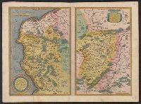
Normandy (France)--Maps--Early works to 1800
Found in:
Beinecke Rare Book and Manuscript Library > Caletensium et Bononiensium ditionis accurata delineatio Veromanduorum Eorumque confinium exactissima descript. Johanne Surhonio Auctore.
Published / Created:
1572]
Call Number:
32am C14 1572
Container / Volume:
BRBL_00074
Image Count:
2
Resource Type:
Maps, Atlases & Globes
Subject (Geographic):
England--Maps--Early works to 1800
Found in:
Beinecke Rare Book and Manuscript Library > Canterbrigia, o pulentiffimi Anglie Regni, orbs celeberrimi nominis, ab Academie conditore Cantabro, Cognominata: A Granta, fluvio vicino, Cairgrant; saxonib. Graunteces fre, Grantebrige iam olim nuncupata.
Published / Created:
1572]
Call Number:
32am C14 1572
Container / Volume:
BRBL_00074
Image Count:
1
Resource Type:
Maps, Atlases & Globes
Subject (Geographic):
England--Maps--Early works to 1800
Found in:
Beinecke Rare Book and Manuscript Library > Canterbrigia, o pulentiffimi Anglie Regni, orbs celeberrimi nominis, ab Academie conditore Cantabro, Cognominata: A Granta, fluvio vicino, Cairgrant; saxonib. Graunteces fre, Grantebrige iam olim nuncupata.
Creator:
Published / Created:
[1593?]
Call Number:
BrSides Folio 2017 35
Image Count:
1
Resource Type:
Maps, Atlases & Globes
Alternative Title:
China regnum
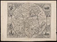
Description:
Appeared in Jode's Speculum orbis terrarum, Blank on verso., Engraving attributed to Antonie Wierix., Manuscript number on verso "No. 114.", Margins include descriptive text and four allegorical-historical vignettes (each 7 cm in diameter)., Relief shown pictorially., and Watermark.
Publisher:
Collectore Cornelio de Iudeis,
Subject (Geographic):
China--Maps--Early works to 1800.
Subject (Name):
Wierix, Antonie, -1604, engraver.
Found in:
Beinecke Rare Book and Manuscript Library > China regnvm.
Creator:
Published / Created:
1572]-1618
Call Number:
1975 Folio 41
Image Count:
1
Resource Type:
Maps, Atlases & Globes
Alternative Title:
Civitates orbis terrarum ...
Publisher:
[Coloniae Agrippinae,
Subject (Geographic):
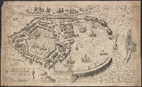
Rome--Antiquities--Early works to 1800 and Rome--Antiquities--Maps
Subject (Topic):
Cities and towns, Medieval and Maps, Pictorial -- (LC)
Found in:
Beinecke Rare Book and Manuscript Library > Civitates orbis terrarvm ...
Published / Created:
1575
Call Number:
40AM F586 1575
Container / Volume:
BRBL_00227
Image Count:
1
Resource Type:
Maps, Atlases & Globes
Publisher:
Io. Iacobus de Rubeis formis,
Subject (Geographic):
Italy--Maps--Early works to 1800
Found in:
Beinecke Rare Book and Manuscript Library > Claudii et Trajani impp. admirabilium portuum ostiensium orthographia per Stephanum du Perach architectum iuxta antiqua vestigia accuratissime delineata. Ant. Lafrer. exc. Romae.
Published / Created:
[1580?]
Call Number:
3247 1580
Container / Volume:
BRBL_00066
Image Count:
2
Resource Type:
Maps, Atlases & Globes
Subject (Geographic):
England--Maps--Early works to 1800
Found in:
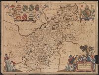
Beinecke Rare Book and Manuscript Library > Comitatus Northantonensis vernacule Northamtonshire.
Published / Created:
1595
Call Number:
434 K83 1595
Container / Volume:
BRBL_00706
Image Count:
1
Resource Type:
Maps, Atlases & Globes
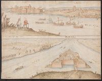
Description:
Color: Light blue and brown. and Two views of Komarno.
Subject (Geographic):
Komarno Czech Republic--Maps, Manuscript--Early works to 1800
Found in:
Beinecke Rare Book and Manuscript Library > Comorra [Komarno, Czechoslovakia]. Communicavit G. Houf [nagel].
Branch:v1.61.8 ,Deployed:2024-06-20T11:15:02-04:00