New map of the kingdom of England and Dominion of Wales, New map of the kingdome of England and Wales, and New mapp of the kingdom of England and Dominion of Wales
Description:
Imperfect: upper right of map mutilated, with some loss of text., No. 4 of 69 maps bound together in composite atlas., Relief shown pictorially., Scale [ca. 1:1 110 000]., With an alphabeticall table of all the cities and market towns in England and Wales., and With dedication To the most serene and most sacred Majesty William III ... from William Berry.
Publisher:
Sold by William Berry at the sign of the Globe between Charing Cross and White Hall
Subject (Geographic):
Great Britain --Maps --Early works to 1800
Subject (Topic):
Roads --Great Britain --Maps --Early works to 1800
Copper engraved sea chart, colored by hand to show coasts of English counties and French providinces, Flanders, Holland, etc ... Loxodromes, direction of compass, shoals, soundings, coastal towns., Decorative title, dedicatory, and scal, and Preliminary record.
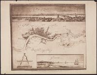
"Emery Walker, ph. sc.", Facsimile., Includes panoramas of London and Greenwich., and Relief shown pictorially.
Publisher:
London Topographical Society,
Subject (Geographic):
Greenwich (London, England)--Aerial views--Early works to 1800--Facsimiles, London (England)--Aerial views--Early works to 1800--Facsimiles, and London (England)--Maps--Early works to 1800--Facsimiles
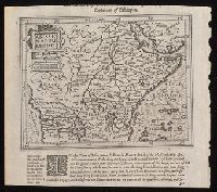
"Dedicata all'. illmo. et eccmo. sig. Michele Foscarini, sauio grande e storiografo della seren. Rep. di Venetia.", Appears in Coronelli's Atlante veneto., Hand col. Sheet measures 49 x 67 cm. dgvmp2008., and Inset: Origine, e corso del Nilo, descrito secondo l'
Publisher:
Si uende presso Dom. Padoani sul ponte di Rialto all' Insegna della Geografia,
Subject (Geographic):
Ethiopia--Maps--Early works to 1800 and Nile River--Discovery and exploration--Maps--Early works to 1800