Skip to search
Skip to main content
Skip to first result
Search
You Searched For
Date
1700 - 1799
Resource Type
Maps, Atlases & Globes
Date Created
1700 to 1799
New Search
Search Results
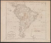
Published / Created:
[1795]
Call Number:
90 1795A
Container / Volume:
BRBL_00661
Image Count:
1
Resource Type:
Maps, Atlases & Globes
Description:
Engraved for Carey's American Edition of Guthrie's Geography improved.
Subject (Geographic):
South America--Maps--Early works to 1800
Found in:
Beinecke Rare Book and Manuscript Library > A Map of South America According to the best Authorities.
Published / Created:
1755
Call Number:
32 Sa25 1755
Container / Volume:
BRBL_00054
Image Count:
1
Resource Type:
Maps, Atlases & Globes
Subject (Geographic):
England--Maps--Early works to 1800
Found in:
Beinecke Rare Book and Manuscript Library > A Map of St. Sepulchers without Charterhouse Liberty and Clarken Well Parish ... for Ston's Survey.
Published / Created:
1755
Call Number:
771ad Al13 1755
Container / Volume:
BRBL_00714
Image Count:
1
Resource Type:
Maps, Atlases & Globes
Description:
Color: pen and ink detail.
Subject (Geographic):
Albany (N.Y.)--Maps, Manuscript--Early works to 1800
Found in:
Beinecke Rare Book and Manuscript Library > A Map of a Tract of 13,000 Acres of Land in the County of Albany on the West Side of Canyadarge Lake granted to David Schuyler and others the 3 June 1755 ... Thomas Palmer, Surv.
Published / Created:
[1775?]
Call Number:
76cea 1775
Container / Volume:
BRBL_00446
Image Count:
1
Resource Type:
Maps, Atlases & Globes
Description:
Insets: The Town of Boston in new England. A Chart of the Atlantic Ocean shewing the Situation of Nova Scotia with the respect to the British Isles.
Publisher:
I. Mount, T. Page & W. Mount,
Subject (Geographic):
New England--Maps--Early works to 1800
Found in:
Beinecke Rare Book and Manuscript Library > A Map of the Coast of New England from Staten Island of Breton; as if was actualy survey'd by Capt. Cyprian Southback.
Published / Created:
[1775?]
Call Number:
76cea 1775A
Container / Volume:
BRBL_00446
Image Count:
1
Resource Type:
Maps, Atlases & Globes
Description:
Insets: The Town of Boston in New England. A Chart of the Atlantic Ocean shewing the situation of Nova Scotia with respect to the British Isles.
Publisher:
I. Mount & T. Page & W. Mount, Tower Hill,
Subject (Geographic):
New England--Maps--Early works to 1800
Found in:
Beinecke Rare Book and Manuscript Library > A Map of the Coast of New England from Staten Island to the Island of Breton; as it was actualy survey'd by Capt Cyprian Southback.
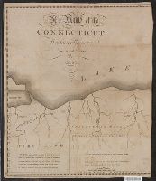
Published / Created:
1798]
Call Number:
8045 1798B
Container / Volume:
BRBL_00546
Image Count:
1
Resource Type:
Maps, Atlases & Globes
Description:
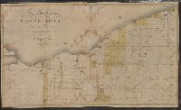
Text: Fire Land so called It being a grant of 500,000 Acres by the Legislature of the State of Connecticut to certain sufferers in the late war with Britain it is presumed that the Eastern.
Subject (Geographic):
Western Reserve (Ohio)--Maps
Found in:
Beinecke Rare Book and Manuscript Library > A Map of the Connecticut Western Reserve, from actual Survey, By Seath Pease.
Published / Created:
1798
Call Number:
8045 1798A
Container / Volume:
BRBL_00546
Image Count:
1
Resource Type:
Maps, Atlases & Globes
Description:
Text: Fire Land so called It being a Grant of 500,000 Acres by the Legislature of the State of Connecticut to certain Sufferers in the late war with Britain.
Publisher:
Amos Doolittle,
Subject (Geographic):
Western Reserve (Ohio.)--Maps
Found in:
Beinecke Rare Book and Manuscript Library > A Map of the Connecticut Western Reserve, from actual Survey, by Seth Pease & Abn. Tappen.
Published / Created:
1704
Call Number:
Cxb e678ge
Collection Title:
The history of the bucaniers of America : from the first original down to this time; written in
Image Count:
1
Resource Type:
Maps, Atlases & Globes
Alternative Title:
[Piratas de América. English]
Publisher:
Printed for T. Newborough [etc.]
Collection Created:
London : Printed for T. Newborough [etc.],
Found in:
Beinecke Rare Book and Manuscript Library > A Map of the Countrey and Citty of Panama. Part 3: Chap: 5.
Published / Created:
1795]
Call Number:
18 1795A
Container / Volume:
BRBL_00012
Image Count:
1
Resource Type:
Maps, Atlases & Globes
Description:
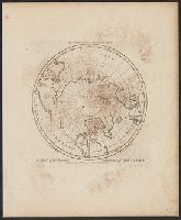
Engraved for Carey's Edition of Guthrie's Geography Improved.
Publisher:
Mathew Carey,
Subject (Geographic):
Arctic Regions--Maps--Early works to 1800
Found in:
Beinecke Rare Book and Manuscript Library > A Map of the Countries situate about the North Pole as far as the 50th Degree of North Latitude. W. Barker, sculp.
Published / Created:
1795]
Call Number:
18 1795
Container / Volume:
BRBL_00012
Image Count:
1
Resource Type:
Maps, Atlases & Globes
Description:
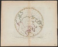
Engraved for Carey's Edition of Guthrie's Geography Improved.
Publisher:
Mathew Carey,
Subject (Geographic):
Arctic Regions--Maps--Early works to 1800
Found in:
Beinecke Rare Book and Manuscript Library > A Map of the Countries situate about the North Pole as far as the 50th Degree of North Latitude. W. Barker, sculp.
Branch:v1.61.8 ,Deployed:2024-06-20T11:15:04-04:00