Also appeared in Faden's [General atlas. London : William Faden, 1811?]., No. 11 of 43 maps bound together in composite atlas., Relief shown pictorially., Scale [ca. 1:505,000]., and Shows forested areas, Banks of Flanders, etc.
Publisher:
William Faden
Subject (Geographic):
Belgium --Maps --Early works to 1800 and Luxembourg --Maps --Early works to 1800
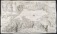
Also appeared in Faden's [General atlas. London : William Faden, 1811?]., Imperfect: torn along some folds, with no loss of text., Includes ornamental cartouche., No. 16 of 43 maps bound together in composite atlas., Prime meridians: Ferro and London., Relief shown pictorially., Scale [ca. 1:2,850,000]., and Sheets fit together with overlap.
Also appeared in Faden's [General atlas. London : William Faden, 1811?]., No. 10 of 43 maps bound together in composite atlas., Relief shown pictorially., and Scale [1: 510,000].
Map of the world showing routes of Cook's expeditions, with notes on ice, wild life etc. seen. Relief shown pictorially; imaginary coastline for eastern coast of Australian Bight., No. 1 of 43 maps bound together in composite atlas., and Scale [ca.1:68 000 000].
Publisher:
Published by Wm. Faden, Geographer to the King, Charing Cross
Subject (Name):
Cook, James, 1728-1779 and Mulgrave, Constantine John Phipps, Lord
Subject (Topic):
Discoveries in geography --Maps --To 1800 and World maps --Early works to 1800
Also appeared in Faden's [General atlas. London : William Faden, 1811?]., Hand-coloring of political borders differ from 1982 Folio 10, no. 20., No. 20 of 43 maps bound together in composite atlas., No. 21 of 43 maps bound together in composite atlas., Relief shown pictorially., and Scale [ca. 1:2,150,000].
Publisher:
William Faden
Subject (Geographic):
Europe --Maps --Early works to 1800, Germany --Administrative and political divisions --Maps --Early works to 1800, and Germany --Maps --Early works to 1800
Eastern old world hemisphere has imprint: London ... Dec. 1st, 1786 by William Faden., No. 2 of 43 maps bound together in composite atlas., Scale [1:60,000,000]., and Shows western and eastern hemispheres separately.
Ed. statement appears on Northern Hemisphere map only., No. 3 of 43 maps bound together in composite atlas., Relief shown pictorially., Scale [ca. 1:41,000,000. At equator]., and Shows tracks of various ocean voyages.
Publisher:
William Faden
Subject (Geographic):
Northern Hemisphere --Maps --Early works to 1800 and Southern Hemisphere --Maps --Early works to 1800
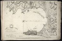
Also appeared in Faden's [General atlas. London : William Faden, 1811?]., In cartouche above title: The Roman obsidional crown, Parcere subjectis et debellare superbos., No. 15 of 43 maps bound together in composite atlas., Oriented with north toward right., Relief shown by hachures; depths by soundings., Scale [ca. 1:24,700]., and Shows ocean currents, buildings, forts, fields, magnetic declination, etc.
Publisher:
William Faden
Subject (Geographic):
Gibraltar --History --Siege, 1779-1783 --Maps --Early works to 1800, Gibraltar --Maps --Early works to 1800, and Gibraltar, Bay of (Spain) --Maps --Early works to 1800
British & Spanish territories according to the treaty of 1784
Description:
For a description of the second and third states see Stevens and Tree, Comparative Cartography, Map Collectors' Circle (1967)., Includes historical notes and a color key., Includes text., No. 40 of 43 maps bound together in composite atlas., Prime meridian: London., Relief shown pictorially., Scale [ca. 1:6,750,000]., and Shows numerous boundary changes.
Publisher:
Willm. Faden
Subject (Geographic):
United States --Boundaries --Maps --Early works to 1800 and United States --Maps --Early works to 1800