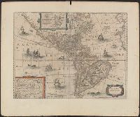
Appears in various eds. of Jansson's Nieuwen atlas., Dutch text on verso., Includes ill. of ships and sea monsters, and insets showing "Polus Arcticus" region and "Terra Australis incognita.", Relief shown pictorially., and Sheet measures 50.1 x 60.9 cm.
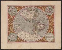
Ancillary maps: Golfo Mexicano, Cuba, Haiti nunc Hispaniola., Includes notes and decorative floral border., Map was published in "Atlas sive Cosmographicae" by Jodocus Hondius in 1613. Map was again published in the 1623 and 1630 edition by Henricus Hondius., Relief shown pictorially., Sheet measures 47.7 x 58.2 cm. Cross Collection no. 115., and Verso: signature "M" on page 39, page 40. Text in Latin.
Publisher:
s.n.,
Subject (Geographic):
America--Maps--Early works to 1800 and Western Hemisphere--Maps--Early works to 1800
Subject (Name):
Hondius, Hendrik, 1597-1651. Atlas sive Cosmographicae and Hondius, Jodocus, 1563-1612. Atlas sive Cosmographicae
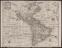
From Heylin's Cosmographie ... London : Printed for Henry Seile ..., 1652., Label on verso [with ms. nos.]: 559/122. Sheet measures 35.2 x 45.8 cm. Cross Collection no. 119., Relief shown pictorially., and Shows California as an island.
Publisher:
Impensis Henrici Seile,
Subject (Geographic):
America--Maps--Early works to 1800
Subject (Name):
Heylyn, Peter, 1600-1662. Microcosmus and Trevethen, William, engraver
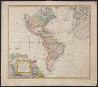
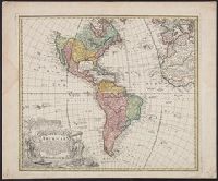
"Seb. Dorn sc.", At least three states of the 1746 map exist: one state has the privilige statement "Cum Privil S.C.M." following publisher and preceding date in the cartouche, but without engraver statement "Seb. Dorn, sc." below, and Relief shown pictorially.
Publisher:
In lucem proferentibus Homannianis Heridibus,
Subject (Geographic):
America--Maps--Early works to 1800 and Western Hemisphere--Maps--Early works to 1800
Subject (Name):
Boehme, August Gottlieb, 1719-1797, Dorn, Sebastian, engraver, and Hase, Johann Matthias, 1684-1742
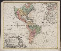
"Seb. Dorn sc.", At least three states of the 1746 map exist: one state has th, Copy 2: Without privilege statement in cartouche and with engraver statement. Stamp on verso: Horace Brown, Yale, 1900S. Sheet measures 53.2 x 64.3 cm., and Relief shown pictorially.
Publisher:
In lucem proferentibus Homannianis Heridibus,
Subject (Geographic):
America--Maps--Early works to 1800 and Western Hemisphere--Maps--Early works to 1800
Subject (Name):
Boehme, August Gottlieb, 1719-1797, Dorn, Sebastian, engraver, and Hase, Johann Matthias, 1684-1742
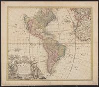
At least three states of the 1746 map exist: one state has the privilige statement "Cum Privil S.C.M." following publisher and preceding date in the cartouche, but without engraver statement "Seb. Dorn, sc." below neat line; another state has no privilege statement, but has engraver statement below neat line; and another state has no privilege statement or engraver statement, but lists "Falkland" below I. Malouines (off the southern coast of Argentia), which is missing from all other states., Relief shown pictorially., and With privilege statement in cartouche. Sheet measures 50 x 59.5 cm. Verso: "8" in ink ms. Franklin Collection.
Publisher:
In lucem proferentibus Homannianis Heredibus,
Subject (Geographic):
America--Maps--Early works to 1800 and Western Hemisphere--Maps--Early works to 1800
Subject (Name):
Boehme, August Gottlieb, 1719-1797 and Hase, Johann Matthias, 1684-1742
At least three states of the 1746 map exist: one state has the privilige statement "Cum Privil S.C.M." following publisher and preceding date in the cartouche, but without engraver statement "Seb. Dorn, sc." below neat line; anot and Relief shown pictorially.
Publisher:
In lucem proferentibus Homannianis Heredibus,
Subject (Geographic):
America--Maps--Early works to 1800 and Western Hemisphere--Maps--Early works to 1800
Subject (Name):
Boehme, August Gottlieb, 1719-1797 and Hase, Johann Matthias, 1684-1742