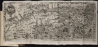
Histoire de la Nouvelle France : contenant les navigations, decouvertes, & habitations faites par
Image Count:
1
Alternative Title:
Figure de la terre neuve, grande ri
Description:
Bound in after p. 236., Depicts coat of arms of Henry IV of France., In pencil on verso: 236., Map has one small hole along fold of second panel at the top., Map has several small brown marks, most notably on the verso., and Scale [ca. 1:9,428,600].
Subject (Geographic):
Acadia --Early works to 1800, America --Discovery and exploration --French --Early works to 1800, New France --Discovery and exploration --Early works to 1800, and New France --Maps --Early works to 1800
Subject (Name):
Millot, Jean, b. 1582, printer, Swelinck, Jan, engraver
, and Villegaignon, Nicolas Durand de, 1510-1571?
Subject (Topic):
Indians of North America --Early works to 1800 and Indians of North America --Nova Scotia --Early works to 1800
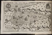
Histoire de la Nouvelle-France : contenant les navigations, decouvertes, & habitations faites par
Image Count:
1
Description:
Bound in after p. 496., In pencil in upper left corner: 497., Map has three or four small brown marks on verso, the largest of which is on the right margin., and Scale not given.
Subject (Geographic):
America --Discovery and exploration --French --Early works to 1800, New France --Discovery and exploration --Early works to 1800, and New France --Maps --Early works to 1800
Subject (Name):
Millot, Jean, b. 1582, printer, Swelinck, Jan, engraver, and Villegaignon, Nicolas Durand de, 1510-1571?
Broeck, Crispin van den, 1524-ca. 1591 Visscher, Nicolaes, 1618-1679
Published / Created:
[ca. 1660]
Call Number:
1983 Folio 19
Collection Title:
[Atlas factice of 96 maps by Blaeu, Visscher, Jansson, Hondius and others]
Image Count:
2
Alternative Title:
Armenia Maior and Asia et Armenia Minor
Description:
Imperfect: illustrations at top cut-out and replaced with ms. titles "Asia et Armenia minor" (upper left) and "Armenia minor" (in upper right); torn along fold and at left edge, with some loss of text. Sheet measures 32 x 47.8 cm. Reinforced along edges with printed waste. No. 85 of 92 maps bound together. and Numbered 91 on verso.
Publisher:
[Nicolaes Visscher]
Subject (Geographic):
Armenia --Maps --Early works to 1800, Assyria --Maps, Egypt --Maps --Early works to 1800, Middle east --Maps --Early works to 1800, Palestine --Geography --Maps --Early works to 1800, Saudi Arabia --Maps, Syria --Maps, and Turkey --Maps
Regnum Congo hoc est vera descriptio regni Africani : quod tam ab incolis quam Lusitanis Congus
Image Count:
1
Abstract:
Engraved title page depicting a three-headed being at top, other figures in ethnic dress, and three native figures at bottom supporting the title within its frame.
Imperfect: plates 4, 27 and 37 wanting; 2 maps (Nova tabula insularum Iavae, Sumatrae, Borneonis ... and Ailhae cidade de Goa ...) wanting. The other map and plate issued with this part, and 4 maps issued with part 3, are bound preceeding this part in the following order: [1] A cidade de Angra ... (40 x 55 cm. on sheet 41 x 57 cm, folded to 30 x 15); [2] Descriptio Hydrograhica accomodata ad Battavorum navagatione in Javam isulam Indiae Orientalis... (34 x 65 cm, on sheet 36 x 65 cm, folded to 29 x 18 cm); [3] Insula D. Helenae ... (22 x 28 cm, on sheet 30 x 31); [4] Munken so in den Orientalischen Indien ... (14 x 18 cm, on sheet 19 x 30 cm) bound with top of sheet at gutter; [5] Vera effigies et delineatio Insulae Ascenstio ... (15 x 22 cm, on sheet 19 x 30 cm) bound with top of sheet at gutter; [6] Insulae et arcis Mocambique ...(21 x 27 cm, on sheet 31 x 30 cm). Some text has been censored in black ink. No. 2 of 3 titles bound together.
Publisher:
Ex officina Wolfgangi Richteri,
Subject (Geographic):
Indonesia--Description and travel--Early works to 1800.
Subject (Name):
Linschoten, Jan Huygen van, 1563-1611. Navigatio in Orientem.