Engraved t.-p., within ornamental border., Errata: p. [1] at end., Imperfect: 2 p.l. and first map, "Orbis terrarum," wanting; autograph of Amadeus Canalius; unidentified bookplate: Sc. 8. D N. 28., and Signatures: [*]⁴ A-Aa⁴.
Publisher:
Tijpis Iohannis Bogardi,
Subject (Geographic):
America--Discovery and exploration., America--Early accounts to 1600., and America--Maps--Early works to 1800.
Geografia di Clavdio Tolomeo Alessandrino and Geographia. Italian. 1599
Description:
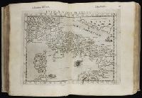
"Avertimento di Gioseppe Rosaccio, sopra i disegni delle tavole di Tolomeo", leaf 42, 2nd count, has separate caption title., "Della geografia di Clavdio Tolomeo Alessandrino ..." books two through eight, leaves 1 recto-186 recto, 4th count, contain the 27 old in text double maps, on inner forms of leaves with descriptive text. Note that the list of maps in book 1 given on leaves 1 recto and 2 verso do not reflect the cartographic contents within., "Della Geografia di Clavdio Tolomeo Alessandrino", leaves 1-41, 2nd count, has separate caption title., "Descrittione della Geografia vniversale, con tavole qvarantadve d'intaglio di rame, nelle quali secondo u più moderni geografi sono poste le prouincie, regni, città, castelli, monti, fiumi, laghi, porti, golfi, isole, & altre particolarità di tutta la terra; con discorsi fatti da Gioseppe Rosaccio, sopra di ciascuna tauola", leaves 1-144, 3rd count, contain the 41 modern in text double maps, in inner forms of leaves with descriptive text., "Espositioni, et introdvttioni vniversali di Girolamo Rvscelli sopra la Geografia di Clavdio Tolomeo Alessandrini", leaves [1-27], 5th count, has separate dated title page with imprint: In Venetia, M D XCVIII. Appresso gli heredi di Melchior Sessa., "Tavola de' nomi antichi, et moderni di tutte le prouincie, regioni, regni, città, castelli, ville, monti, fiumi, mari, selue, paludi, golfi, isole, capi, popoli, & altre cose notabili, contenute in tutto il presente volume di Tolomeo", leaves [11] recto-[36] verso, 1st count, has separate caption title., "Tavola delle cose piv notabili, che nella Geografia vniversale del Rosaccio si contengono", leaves [5] recto-[10] recto, 1st count, has separate caption title., (Titles of maps bound between leaves 1-144, 3rd count) [1]. Orbis terrae compendiosa descriptio -- [2]. Orbis descriptio -- [3]. Evropa -- [4]. Anglia et Hibernia nova -- [5]. Hispania nova tabvla -- [6]. Gallia nova tabvla -- [7]. Flandra, Brabantia et Holanda nova -- [8]. Tavola nvova di Germania -- [9]. Tavola nvova di Schiavonia -- [10]. Tavola nvova d'Italia -- [11]. Tavola nvova di Piemonte -- [12]. Tavola nvova della Marca d'Ancona -- [13]. Toscana nvova tavola -- [14]. Tavola Nvova di Sardegna et di Sicilia -- [15]. Polonia et Hvngaria nvova tavola -- [16]. Schonladia nvova -- [17]. Tavola nvova di Prvssia et di Livonia -- [18]. Di Hvngaria et Transilvania tavola novissima -- [19]. Graetia nvova tavola -- [20]. Africa -- [21]. Mavritania nvova tavola -- [22]. Africa minor nvova tavola -- [23]. Marmarica nvova tavola -- [24]. Egitto nvova tavola -- [25]. Africa nvova tavola -- [26]. Asia -- [27]. Natolia nvova tavola -- [28]. Soria et Terra Santa nvova tavola -- [29]. Persia nvova tavola -- [30]. Arabia Felice nvova tavola -- [31]. Calecvt nvova tavola -- [32]. India tercera nvova tavola -- [33]. America -- [34]. Tierra nveva -- [35]. Nveva Hispania tabvla nova -- [36]. Tierra nova -- [37]. Brasil nvova tavola -- [38]. Isola Spagnola nova -- [39]. Isola Cvba nova -- [40]. Septentrionalivm partivm nova tabvla -- [41]. Carta marina nvova tavola., (Titles of maps bound between leaves 1-186, 4th count) [1]. Tabvla Evropae I -- [2]. Tabvla Evropae II -- [3]. Tabvla Evropae III -- [4]. Tabvla Evropae IIII -- [5]. Evropae tabvla V -- [6]. Evropae tabvla VI -- [7]. Evropae tabvla VII -- [8]. Evropae tabvla VIII -- [9]. Evropae tabvla IX -- [10]. Tabvla Evropae X -- [11]. Tabvla Aphricae I -- [12]. Tabvla Aphricae II -- [13]. Tabvla Africae III -- [14]. Tabvla Africae IIII -- [15]. Tabvla Asiae I -- [16]. Tabvla Asiae II -- [17]. Tabvla Asiae III -- [18]. Tabvla Asiae IIII -- [19]. Tabvla Asiae V -- [20]. Tabvla Asiae VI -- [21]. Tabvla Asiae VII -- [22]. Tabvla Asiae VIII -- [23]. Tabvla Asiae IX -- [24]. Tabvla Asiae X -- [25]. Tabvla Asiae XI -- [26]. Tabvla Asiae XII -- [27]. Ptolemaei cognita., A quarto edition issued by the heirs of Melchior Sessa in Venice was also printed in 1598., Engraved printer's device on title pages; head and tail pieces; initials; includes in text woodcut diagrams., First printed in Latin in Vicenza in 1475 without maps; the maps from engraved copperplates were first included in the Bologna, 1477 edition., Includes indexes., Inscription on title page: Ex aliij Pajchalij Troije Tea[?]ing Civitatij. Bookplate: Thorne Collection of Cartogaphy and Geography. In vellum binding., Maps show pictorial relief., Roman numeral dated on title pages appear following places of publication., Signatures: *⁴ (*1 verso blank) ²*⁴ ²**² (²**2 verso blank) a-f⁴ g² A-K⁴ L² ²A⁴ ²B⁴ ²C² ²D² ²E-²K⁴ ²L² M⁴ N² O⁴ P-Q² R⁴ S-V² X⁴ Y-Z² 2A-2C² 2D⁴ 2E-2I² 2K⁴ 2L-3N² ³A⁴ ³B-³C² ³D-³E⁴ ³F² ³G-³I⁴ ³K² ³L-³M⁴ ³N-²P² ²Q-²R⁴ ²S² ²T-²X⁴ ²Y² ²Z⁴ ²2A-2B² ²2C-²2D⁴ ²2E² ²2F⁴ ²2G-2H² 2I-2L⁴ ²2M-2P² 2Q-2R⁴ 2S² 2T-2X⁴ 2Y² 2Z⁴ 3A² 3B⁴ 3C-3E⁴ 3F⁴ 3G-3I⁴ 3K⁴ 3L-3M⁴ 3N-3P⁴ (3P4 verso blank) ²a-²e⁴ ³e⁴ ²f⁴ ( -²f4)., Text primarily in Italian; titles and text on maps in Latin and Italian., and This is another edition of the Geografia translated from the Greek by Girolamo Ruscelli, which was first printed in Venice, 1561, here revised, enlarged, and edited by Giuseppe Rosaccio. The maps are the same as those which appeared in the Venice, 1548 edition which had been originally engraved by Giacomo Gastaldi, but have been retouched with new relief of ships and fish. However, according the Shirley, the regional maps in this edition are basically those which originated by Girolamo Puscelli in 1561, with amendments. The world maps consist of the Ptolemaic one dating from 1574 ([27]. Ptolemaei cognita), the original Carta marina ([41]. Carta marina nvova tavola) from the Venice, 1561 edition, and state 2 of the double-hemispherical world map of the Venice, 1561 edition with the addition of a southern continent ([2]. Orbis descriptio). There is also a fourth world map, almost certainly by Rosaccio himself, consisting of two hemispheres enclosed within a plain border ([1]. Orbis terrae compendiosa descriptio), which is a skillfull reproduction of Mercator's map of 1587 but with parallel latitudinals. Five new modern maps have been added to this edition given by Sabin as: map. [3]. Evropa, [18]. Di Hvungaria et Transilvania novissima, [20]. Africa, [26]. Asia, and [33]. America.
Publisher:
Appresso gli heredi di Melchior Sessa,
Subject (Geographic):
America--Geography--Maps
Subject (Name):
Rosaccio, Giuseppe, approximately 1530-approximately 1620, Ruscelli, Girolamo, -approximately 1565, and Thorne Collection of Cartogaphy and Geography Bookplate.
Subject (Topic):
Geography, Ancient--Maps and Mathematical geography
All volumes bound to match 1973 Folio 72. Factitious collection of about 549 maps taken from the atlases of the 17th and the beginning of the 18th cent., put together with the title "Atlas" and bound in 6 volumes. These volumes originally bore the imprint: Amstelaedamii apvd Reiniervm & Josvam Ottens. Over these words on the title-pages of v. 1-2, 4-6 is the name of Henrik de Leth who painted them. Volume 3 has only the erased imprint of Ottens., For fuller description see Phillips 3448 and C. Koeman's Atlantes Neerlandici, bibliography of terrestrial, maritime and celestial atlases and pilot books, published in the Netherlands up to 1800, Amsterdam c1967-71, v. 2, p. 63-83., and Maps by P. Schenck and son, G. Valck, F. de Wit, N. Visscher and others.
Publisher:
chez J. Covens & C. Mortier,
Subject (Geographic):
Denmark --Maps --Early works to 1800
Subject (Name):
Reiner et Josua Ottens (Firm), Schenk, Peter, 1660-1718 or 1719., and Valck, G. (Gerard), 1651 or 1652-1726.