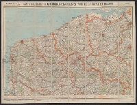
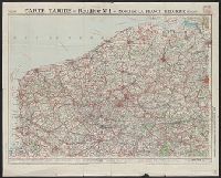
Carte routière pour automobilistes et cyclistes, Carte Taride, Cartes Taride pour automobilistes et cyclistes, and Nouvelle carte de France à l'usage des cyclistes et automobilistes
Description:
Also shows adjacent areas of Germany, Belgium, the Netherlands, Luxembourg, Switzerland, Italy, and Spain., Coverage complete in 34 sheets. Copy 3 incomplete., Each sheet separately numbered and titled: e.g., no. 3, Environs de Paris, section nord-est ; no. 27, Les bords du Rhin, Mayence à Strasbourg., Relief shown by shading and spot heights., and Some sheets dated in lower right corner, e.g., 5-18.
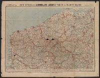
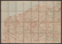
Carte routière pour automobilistes et cyclistes, Carte Taride, Cartes Taride pour automobilistes et cyclistes, and Nouvelle carte de France à l'usage des cyclistes et automobilistes
Description:
Also shows adjacent areas of Germany, Belgium, the Netherlands, Luxembourg, Switzerland, Italy, and Spain., Coverage complete in 34 sheets. Copy 2 incomplete., Each sheet separately numbered and titled: e.g., no. 3, Environs de Paris, section nord-est ; no. 27, Les bords du Rhin, Mayence à Strasbourg., Relief shown by shading and spot heights., and Some sheets dated in lower right corner, e.g., 5-18.
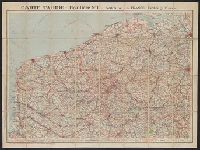
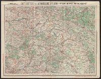
Carte routière pour automobilistes et cyclistes, Carte Taride, Cartes Taride pour automobilistes et cyclistes, and Nouvelle carte de France à l'usage des cyclistes et automobilistes
Description:
Also shows adjacent areas of Germany, Belgium, the Netherlands, Luxembourg, Switzerland, Italy, and Spain., Coverage complete in 34 sheets. Copy 4 incomplete., Each sheet separately numbered and titled: e.g., no. 3, Environs de Paris, section nord-est ; no. 27, Les bords du Rhin, Mayence à Strasbourg., Relief shown by shading and spot heights., and Some sheets dated in lower right corner, e.g., 5-18.
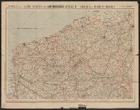
Carte routière pour automobilistes et cyclistes, Carte Taride, Cartes Taride pour automobilistes et cyclistes, and Nouvelle carte de France à l'usage des cyclistes et automobilistes
Description:
Also shows adjacent areas of Germany, Belgium, the Netherlands, Luxembourg, Switzerland, Italy, and Spain., Coverage complete in 34 sheets. Wanting sheets 23-28., Each sheet separately numbered and titled: e.g., no. 3, Environs de Paris, section nord-est ; no. 27, Les bords du Rhin, Mayence à Strasbourg., Relief shown by shading and spot heights., and Some sheets dated in lower right corner, e.g., 5-18.
Carte routière pour automobilistes et cyclistes, Carte Taride, Cartes Taride pour automobilistes et cyclistes, and Nouvelle carte de France à l'usage des cyclistes et automobilistes
Description:
Also shows adjacent areas of Germany, Belgium, the Netherlands, Luxembourg, Switzerland, Italy, and Spain., Coverage complete in 34 sheets. Copy 5 incomplete., Each sheet separately numbered and titled: e.g., no. 3, Environs de Paris, section nord-est ; no. 27, Les bords du Rhin, Mayence à Strasbourg., Relief shown by shading and spot heights., and Some sheets dated in lower right corner, e.g., 5-18.
Carte routière pour automobilistes et cyclistes, Carte Taride, Cartes Taride pour automobilistes et cyclistes, and Nouvelle carte de France à l'usage des cyclistes et automobilistes
Description:
Also shows adjacent areas of Germany, Belgium, the Netherlands, Luxembourg, Switzerland, Italy, and Spain., Coverage complete in 34 sheets. Copy 6 incomplete., Each sheet separately numbered and titled: e.g., no. 3, Environs de Paris, section nord-est ; no. 27, Les bords du Rhin, Mayence à Strasbourg., Relief shown by shading and spot heights., and Some sheets dated in lower right corner, e.g., 5-18.
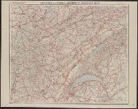
Nouvelle carte de France à l'usage des cyclistes et automobiles.
Description:
"7-09"--Bottom right corner., "No. 10"--Upper left corner., No. 10 in series "Nouvelle carte de France à l'usage des cyclistes et automobiles.", Relief shown by spot heights., Scale of kilometers., and Shows the France-Comté region of eastern France and French speaking western Switzerland from Montbeliard, France in the north to Geneva, Switzerland in the south, and west from Macon, France to Berne, Switzerland in the east. Includes the Jura Mountains, Lake Geneva and Lake of Neuchatel.
Publisher:
A. Taride,
Subject (Geographic):
Franche-Comté (France)--Maps, Jura Mountains (France and Switzerland)--Maps, and Switzerland, French-speaking--Maps
Subject (Name):
Bineteau, P
Subject (Topic):
Bicycle trails--France--Franche-Comté--Maps, Bicycle trails--Jura Mountains (France and Switzerland)--Maps, Bicycle trails--Switzerland, French-speaking--Maps, Roads--France--Franche-Comté--Maps, and Roads--Jura M