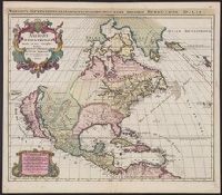
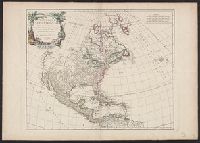
America septentrionalis in suas praecipuas partes divisa, ad usum serenissimi Burgundiae ducis
Description:
Hand col. Sheet measures 53.4 x 61.4 cm. Stamped on verso: Yale, Horace Brown, 1900S., Includes decorative cartouche., Includes six bar scales., Prime meridian: Ferro., Relief shown pictorially., and Watermark.
Appears in Robert de Vaugondy's Atlas universel., Bar scales given in "mille par geometriques, de 60 au degre," "lieues marines ou d'une heure, de 20 au degre," and "lieues d'Espagne, de 17 1/2 au degre.", Cross Collection no. 331., Ornamental cartouche., Relief shown pictorially., Shows Indian tribes, etc., and Title in ms. on verso, with ms. no.: 113.
Publisher:
s.n.],
Subject (Geographic):
South America--Maps--Early works to 1800
Subject (Name):
Robert de Vaugondy, Gilles, 1688-1766. Atlas universel
Engraved map, boundaries of provinces and countries shown by doted lines, mountains by pictorical hachuring., Inset: Iles Gallapagos 1:9,000,000 7x7 cm., It is apparently from an unidentified atlas, being marked no.2, Amérique Méridionale, in the upper left corner, as part of the original engraving., Not listed by either L.C. or B.W. Latter lists Atlas Portatif et Itinéraire de l'Europe, Dressée par J.B.P., 1816., this hand writing seems identical with that on the map of South America by Pierre Lapie, marked: J.A. Noiret., and Written on by hand in left margin: Written on by handin left margin: Caracas, Cumana, Sta fe de bogota; Popayan; quito; Lima; arequipa; chicas. Written on by hand off east coast: Rio Janeire; Ile fte catherine; montevideo en Buenos aires.
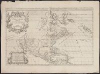
Amérique Septentrionale, divisée en ses principales parties ... les Terres Arcticques, le Canada ou Nouvelle-France, le Mexique ou Nouvelle Espagne, le Nouveau Mexique, les Isles de Terre Neuve, de Californie, et Antillis ou sont distingues les uns des
Description:
Date from upper right margin; "1674" listed in lower left cartouche., Includes eight bar scales., Relief shown pictorially., Similar to McLaughlin, G. Mapping of California as an island, 55 and Lowery 169., Stamp on verso: Yale, Horace Brown, 1900S., and Watermark
Publisher:
Chez H. Iaillot, joignant les grands Augustins aux deux Globs., avec privilege du Roy pour vingt ans,
"Dedié au Roy par son très humble, très obeissant, très fidele suget et serviteur. Hubert Iaillot, géographe de Sa Majeste.", Appears in Jaillot's Atlas françois., Boundaries hand colored., Includes eight bar scales., Relief shown pictorially., and Sheet mea
Subject (Geographic):
North America--Maps--Early works to 1800
Subject (Name):
Albany Institute Stamp, Cordier, Louis, -1711, engraver, and Jaillot, Alexis Hubert, 1632?-1712. Atlas françois
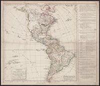
Anville, Jean Baptiste Bourguignon d', 1697-1782, cartographer
Published / Created:
[1748]
Call Number:
90 1748
Collection Title:
[Atlas général]. [Paris : Jean Baptiste Bourguignon d'Anville, 1771].
Container / Volume:
BRBL_00698
Image Count:
3
Resource Type:
Maps, Atlases & Globes
Description:
"Gravé par Guill? Delahaye.", Cross Collection no. 330., From Anville's Atlas général., Include 4 bar scales., Prime meridian: Ferro., Relief shown pictorially., Title in ms. on verso. Sheets numbered in ms. on verso: 115; 117; 119., and Watermarks.
Publisher:
Chez l'auteur, aux Galeries du Louvre,
Subject (Geographic):
South America--Maps--Early works to 1800
Subject (Name):
Anville, Jean Baptiste Bourguignon d', 1697-1782. Atlas général and Haye, G. de la, engraver