Map showing the communication of the lakes and the rivers between Lake Superior and Slave Lake in North America
Description:
"Gent. Mag. March 1790, Pl. I, p. 197" in upper right hand corner., Mounted on linen. Sheet measures 20.7 x 24.3 cm. Cross Collection no. 178., Prime meridian: London., and Relief shown by hachures.
Publisher:
s.n., 1790?]
Subject (Geographic):
Canada--Maps--Early works to 1800 and North America--Maps--Early works to 1800
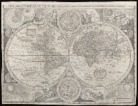
New and accurat map of the world and New and accurate map of the world
Description:
Attributed to Robert Walton; based on a map by John Speed., From Denis Petau's History of the world (1659)., Includes insets of "The heavens and elements," "The eclipse of the sunn," "A figure of the spheare," and "The eclipse of the moone," 2 celestial hemispheres, historical notes, and illustrations., Relief shown pictorially., Shows California as an island., and Watermark.
Subject (Name):
Petau, Denis, 1583-1652 and Speed, John, 1552?-1629