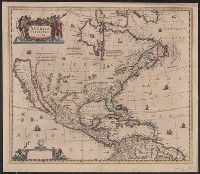
Includes col. ill. of ships, monsters, etc., Possibly from the 1639, 1641, or 1642 ed. of the author's Noveau theatre du monde ou nouvel atlas, or from the 1646, 1647, or 1649 ed. of J. Jansson's Nouvel atlas ou theatre du monde., and Relief shown pictorially.
From Jansonius's and Hondius's Atlas novus ... Amstelodami : Apud Ionnem Ianssonium & Henricum Hondium, 1638., Hand col. Mounted on linen. Sheet measures 50.6 x 58.4 cm. Cross collection no., Latin text on verso; with signature 4O., and Relief shown pictorially.
Publisher:
s.n.,
Subject (Geographic):
North America--Maps--Early works to 1800
Subject (Name):
Hondius, Hendrik, 1597-1651. Atlas novus and Jansson, Jan, 1588-1664. Atlas novus
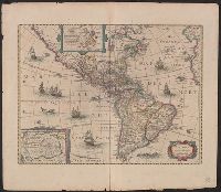
From Janssonius's and Hondius's Atlas novus ... Amstelodami : Apud Ionnem Ianssonium & Henricum Hondium, 1638., Hand col. Sheet measures 50.7 x 58.1 cm. Cross Collection no. 117., Latin text on verso., and Two polar insets.
Publisher:
Henry Hondius,
Subject (Geographic):
Western Hemisphere--Maps--Early works to 1800
Subject (Name):
Hondius, Hendrik, 1597-1651. Atlas novus and Jansson, Jan, 1588-1664. Atlas novus
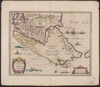
Bar scales in "Miliaria Germanica communia" and "Miliaria Gallica communia.", From Jan Jansson and Henrik Hondius's Atlas novus ... Amstelodami : Apud Ionnem Ianssonium & Henricum Hondium, 1638., In Latin on verso, with caption title "Freti Magellanici et freti le Marii descriptio" and signature 5F., and Relief shown pictorially.
Publisher:
Hendrik Hondius,
Subject (Geographic):
Magellan, Strait of (Chile and Argentina)--Maps--Early works to 1800
Subject (Name):
Hondius, Hendrik, 1597-1651. Atlas novus and Jansson, Jan, 1588-1664. Atlas novus
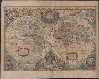
Nova totivs terrarvm orbis geographica ac hydrographica tabvla
Description:
Appears in Jan Jansson's Appendix novi Atlantis (1637) and Jan Jansson and Hendrik Hondius's Atlas novus (1638)., Double hemisphere on sheet, with portraits of Ptolemy, J. Hondius, Caesar and Mercator., Relief shown pictorially., and With dedication to David Sanclarus, Antonius de Willon and Martinius by Hendrik Hondius, dated 1630.
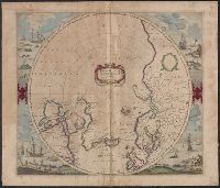
Cross collection no. 48., From: Mercator's Atlas, or, A geographicke description of the regions, countries and kingdoms of the world [1641?], Includes decorative title cartouche, blank dedication cartouche, and four illustrations (colored engravings) of Arctic whaling scenes., Polar projection., and Relief shown pictorially.
Publisher:
Jan Jansson and Hendrik Hondius,
Subject (Geographic):
Arctic Regions--Maps--Early works to 1800, North Pole--Maps--Early works to 1800, and Northern Hemisphere--Maps--Early works to 1800
Subject (Name):
Jansson, Jan, 1588-1664 and Mercator, Gerhard, 1512-1594. Atlas, or, A geographicke description of the regions, countries and kingdomes of the world
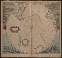
Appears in J. Jansson and H. Hondius' Atlas novus., Includes marginal ill. and title and blank cartouches., Latin text on verso., and Relief shown pictorially.
Publisher:
H. Hondius and J. Jansson,
Subject (Geographic):
Antarctica--Maps--Early works to 1800 and Southern Hemisphere--Maps--Early works to 1800
Subject (Name):
Jansson, Jan, 1588-1664 and Jansson, Jan, 1588-1664. Atlas novus