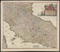
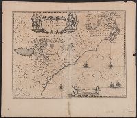
Appears in various editions of Wit's Atlas., Bar scales in "Milliaria Germanica communia 15 in uno gradu," "Milliaria Gallica magna, sive horae itineris,, Relief shown pictorially., and Sheet measures 53.3 x 62.1 cm. Ms. no. in upper right corner: 113.
Publisher:
Frederik de Wit?,
Subject (Geographic):
Tuscany (Grand Duchy)--Maps--Early works to 1800
Subject (Name):
Rodriguez, José M.--Bookplate and Wit, Frederik de. Atlas
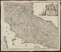
Appears in various editions of Wit's Atlas., Bar scales in "Milliaria Germanica communia 15 in uno gradu," "Milliaria Gallica magna, sive horae itineris," and "mil, Relief shown pictorially., and Sheet measures 53.3 x 62.1 cm. Ms. no. in upper right corner: 113.
Publisher:
Frederik de Wit?,
Subject (Geographic):
Tuscany (Grand Duchy)--Maps--Early works to 1800
Subject (Name):
Rodriguez, José M.--Bookplate and Wit, Frederik de. Atlas
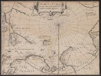
Tabula geographia in qua admirandae navigationis cursus et recursus designatur
Description:
Cross collection no. 52., From: Rerum et urbis Amstelodamensium historia. Amsterodami : Excudit J. Hondius, 1611., In upper right: Fol. 168., and Includes text.
Publisher:
J. Hondius,
Subject (Geographic):
Arctic Regions--Maps--Early works to 1800
Subject (Name):
Hondius, Jodocus, 1563-1612 and Pontanus, Johannes Isacius, 1571-1639. Rerum et urbis Amstelodamensium historia
Afheeldinghe der custen des landts Guinea, Manicongo, ende Angôla, ende voorts tot voorby de C. de boa esperança and Delineatio orarum maritimarum, terrae vulgo indigetatae terra do Natal item Sofalae, Mozambicae & Melindae ...
Description:
Appears in the author's, Companion map to Delineatio orarum maritimarum, terrae vulgo indigetatae terra do Natal item Sofalae, Mozambicae & Melindae ..., Has watermark., Relief shown pictorially., and Title in Latin and Dutch. Place names in Latin and Portuguese.
Publisher:
Arnold Florent van Langren,
Subject (Geographic):
Africa, Southern--Maps--Early works to 1800
Subject (Name):
Langren, Arnold Florent van, 1580-1644 and Linschoten, Jan Huygen van, 1563-1611. Itinerario, voyage ofte schipvaert van Jan Huygen van Linschoten naer Oost ofte Portugaels Indien
Subject (Topic):
Coasts--Africa, Southern--Maps--Early works to 1800
Afheeldinghe der custen des landts Guinea, Manicongo, ende Angôla, ende voorts tot voorby de C. de boa esperança and Delineatio orarum maritimarum, terrae vulgo indigetatae terra do Natal item Sofalae, Mozambicae & Melindae ...
Description:
Appears in the author's Itinerario, voyage ofte schipvaert van Jan Huygen van Linschoten naer Oost ofte Portugaels Indien., Includes views of Ascension Island and Sain, Relief shown pictorially., and Title in Latin and Dutch. Place names in Latin and Portuguese.
Publisher:
Arnold Florent van Langren,
Subject (Geographic):
Africa, Southern--Maps--Early works to 1800
Subject (Name):
Langren, Arnold Florent van, 1580-1644 and Linschoten, Jan Huygen van, 1563-1611. Itinerario, voyage ofte schipvaert van Jan Huygen van Linschoten naer Oost ofte Portugaels Indien
Subject (Topic):
Coasts--Africa, Southern--Maps--Early works to 1800
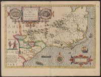
First appeared in Gerhard Mercator's atlas brought out by Jodocus Hondius beginning in 1606., Inc, Latin text on verso; with caption title "Virginia et Florida," signature 7Q, and catchword "Florida.", and Sheet measures 40.4 x 54.1 cm. Cross Collection no. 214.
Publisher:
Jodocus Hondius?,
Subject (Geographic):
Florida--Maps--Early works to 1800, South Atlantic States--Maps--Early works to 1800, and Virginia--Maps--Early works to 1800
Subject (Name):
Hondius, Jodocus, 1563-1612 and Mercator, Gerhard, 1512-1594. Atlas
Appears in French eds. of Gerhard Mercator's Atlas (1628 and 1635)., Includes notes, col. ill., and cartouche with a view of a Florida Indian village on the left and a Virginia Indian village on the right., Relief shown pictorially., and Sheet measure
Publisher:
Hendrik Hondius,
Subject (Geographic):
Florida--Maps--Early works to 1800, South Atlantic States--Maps--Early works to 1800, and Virginia--Maps--Early works to 1800
Subject (Name):
Hondius, Hendrik, 1597-1651 and Mercator, Gerhard, 1512-1594. Atlas. French
Prime meridian Ferro., Signature has been corrected in ms. to "G." Sheet measures 50.3 x 58.2 cm. Franklin 131 16, and Verso in German, with running and caption title "Die Insel Florida," paginated 29, signature 2E, and Hispanien at foot of 1st column on p. 29.
Publisher:
s.n.,
Subject (Geographic):
South Atlantic States--Maps--Early works to 1800
Subject (Name):
Blaeu, Willem Janszoon, 1571-1638. Theatrum orbis terrarum. German