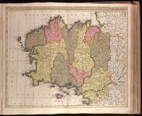
Appeared in Valk and Schenk's Atlantis sylloge compendiosa, ca. 1702., Backed with paper. Ms. no. "60" in upper right-hand corner. Sheet measures 53.6 x 62.8 cm. No. 55 of 87 maps bound together., Bar scales given in "milliaria Gallica" and "milliaria Germanica.", Prime meridian: Ferro., Relief shown pictorially., and Variation of Koeman, C. Atlantes Neerlandici, III, p. 138 (map 23); with addition of "Leo. Valk."
Publisher:
Gerard and Valk,
Subject (Geographic):
Brittany (France)--Maps--Early works to 1800.
Subject (Name):
Schenk, Peter, 1660-1718 or 1719. Atlantis sylloge compendiosa., Valck, G. (Gerard), 1651 or 1652-1726. Atlantis sylloge compendiosa., and Valck, Leonard, 1675-1746.
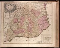
Appeared in Valk and Schenk's Atlantis sylloge compendiosa, ca. 1702., Backed with paper. Ms. no. "83" in upper right-hand corner. Sheet measures 53.5 x 62.0 cm. No. 77 of 87 maps bound together., Bar scales given in "milliaria Hungarica" and "milliaria Germanica.", Prime meridian: Ferro., and Relief shown pictorially.
Publisher:
Gerard and Leonard Valk,
Subject (Geographic):
Romania--Maps--Early works to 1800.
Subject (Name):
Schenk, Peter, 1660-1718 or 1719. Atlantis sylloge compendiosa. and Valck, G. (Gerard), 1651 or 1652-1726. Atlantis sylloge compendiosa.
Appears in Valk and Schenk's Atlantis sylloge compendiosa, ca. 1702., Backed with paper. Ms. no. "64" in upper right corner. Sheet measures 53.7 x 62.1 cm. No. 59 of 87 maps bound together., Includes 5 bar scales., Prime meridian: Ferro., Relief shown pictorially., and Watermark.
Publisher:
Gerard Valck,
Subject (Geographic):
Catalonia (Spain)--Maps--Early works to 1800.
Subject (Name):
Schenk, Peter, 1660-1718 or 1719. Atlantis sylloge compendiosa., Valck, G. (Gerard), 1651 or 1652-1726. Atlantis sylloge compendiosa., and Valck, Leonard, 1675-1746.
"C. privi.", Appeared in Peter Schenk's Atlas contractus [ca. 1700]., Backed with paper. Ms. no. "38" in upper-right corner. Sheet measures 53.7 x 62.4 cm. No. 37 of 87 maps bound together., Bar scales given in "milliaria Germanica," "milliaria Francica," and "milliaria geometrica sive Italica"., Prime meridian: Ferro., Relief shown pictorially., and Watermark.
Publisher:
Peter Schenk],
Subject (Geographic):
Benelux countries--Maps--Early works to 1800.
Subject (Name):
Schenk, Peter, 1660-1718 or 1719. Atlas contractus.
Backed with paper. Ms. no. "67" in upper-right corner. Sheet measures 53.7 x 62.3 cm. No. 62 of 87 maps bound together., Bar scales given in "milliaria Italica" and "milliaria Germanica.", and Prime meridian: Ferro.
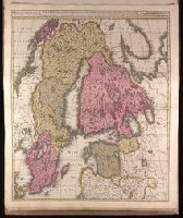
Appeard in Gerard Valck and Peter Schenk's Atlantis sylloge, ca. 1702., Backed with paper. Ms. no. "5" in upper left-hand corner. Sheet measures 62.8 x 53.4 cm. No. 4 of 87 maps bound together., Bar scales given in "milliaria Germanica" and "milliaria Suecia sive Danica"., Prime meridian: Ferro., and Relief shown pictorially.
Publisher:
Gerard Valck,
Subject (Geographic):
Baltic States--Maps--Early works to 1800. and Scandinavia--Maps--Early works to 1800.
Subject (Name):
Schenk, Peter, 1660-1718 or 1719. Atlantis sylloge compendiosa. and Valck, G. (Gerard), 1651 or 1652-1726.. Atlantis sylloge compendiosa.
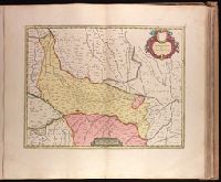
"Cum Privileg. Ord. Gen. Holl. et Westfri.", Appeared in Peter Schenk's Atlas contractus [ca. 1700]., Backed with paper. Ms. no. "32" in lower-right corner. Sheet measures 62.3 x 53.6 cm. No. 31 of 87 maps bound together., Bar scales given in "milliaria Germanica" and "milliaria Gallica"., Prime meridian: Ferro., Relief shown pictorially., and Watermark.
Publisher:
Peter Schenk,
Subject (Geographic):
Alsace (France)--Maps--Early works to 1800., Baden-Württemberg (Germany)--Maps--Early works to 1800., and Saarland (Germany)--Maps--Early works to 1800.
Subject (Name):
Schenk, Peter, 1660-1718 or 1719. Atlas contractus.
"Cum priv. ord. gen. Holl. et Westfr.", Appeared in Peter Schenk's Atlas contractus [ca. 1700]., Backed with paper. Ms. no. "37" in lower-right corner. Sheet measures 63.1 x 53.7 cm. No. 36 of 87 maps bound together., Bar scales given in "milliaria Germanica" and "milliaria Gallica"., Prime meridian: Ferro., Relief shown pictorially., and Watermark.
Publisher:
Peter Schenk,
Subject (Geographic):
Lower Saxony (Germany)--Maps--Early works to 1800. and North Rhine-Westphalia (Germany)--Maps--Early works to 1800.
Subject (Name):
Schenk, Peter, 1660-1718 or 1719. Atlas contractus.
Backed with paper. Ms. no. "68" in upper right corner. Sheet measures 53.7 x 62.3 cm. No. 63 of 87 maps bound together., Bar scale given as "sette miglia Italiane.", Relief shown pictorially., and Watermark.