From Willem and Joan Blaeu's Theatrum orbis terrarum. Amsterdami : Apud Guiljelmum et Iohannem Blaeu, 1635., Signature on verso: I., and Title on verso: Granata & Murcia.
Publisher:
Blaeu,
Subject (Geographic):
Granada (Spain : Province)--Maps--Early works to 1800 and Murcia (Spain : Region)--Maps--Early works to 1800
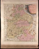
Appeared in Valk and Schenk's Atlantis sylloge compendiosa, ca. 1702., Backed with paper. Ms. no. "29" in upper left-hand corner. Sheet measures 53.5 x 62.5 cm. No. 29 of 87 maps bound together., Includes five bar scales., Prime meridian: Ferro., Relief shown pictorially., and Watermark.
Publisher:
Gerard Valk,
Subject (Geographic):
Switzerland--Maps--Early works to 1800.
Subject (Name):
Schenk, Peter, 1660-1718 or 1719. Atlantis sylloge compendiosa. and Valck, G. (Gerard), 1651 or 1652-1726. Atlantis sylloge compendiosa.
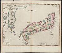
"Cum privilegio Sacrae Caesare Majestatis & ordinum Belgicae Foederatae"., Appeared in various eds. of Martino Martini's Novus atlas Sinensis (published by Blaeu)., Bar scales given in "milliaria Iaponica" and, and With watermark. Sheet measures 51.5 x 59.7 cm.
Publisher:
Joan Blaeu,
Subject (Geographic):
Japan--Maps--Early works to 1800 and Korea--Maps--Early works to 1800
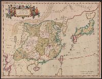
"Cum privilegio Sacrae Caesareae Majestatis, & ordinum Belgicae Foederatae.", Appears in Novus atlas sinensis. 1655., Covers China and Japan., Includes ornamental cartouche with gilt., and Relief shown pictorially.
Publisher:
J. Blaeu,
Subject (Geographic):
China--Maps--Early works to 1800 and Japan--Maps--Early works to 1800
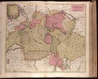
Backed with paper. Ms. no. "27" in upper right-hand corner. Sheet measures 52.7 x 53.7 cm. No. 27 of 87 maps bound together., Bar scales given in "milliaria Germanica" and "mill. Gallica"., Prime meridian: Ferro., and Relief shown pictorially.
Publisher:
Peter Schenk,
Subject (Geographic):
Austria--Maps--Early works to 1800. and Bavaria (Germany)--Maps--Early works to 1800.
"Cum Privilegio Ordin: General: Belgii Foederati.", Backed with paper. Ms. no. "95" in upper right-hand corner. Sheet measures 53.6 x 62.1 cm. No. 85 of 87 maps bound together., Bar scales given in "sesqui milliare Germanicum" and "milliaria Gallica.", Date given by Koeman, v. 5, p. 201, col. 2., and Relief shown pictorially.
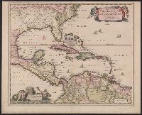
"Cum Privilegio Ordinum Hollandiae et Westfrisiae.", Appears in Visscher's Atlas minor., In, Relief shown pictorially., and Shows the West Indies and Central America from Florida to the northern part of South America, including boundaries, settlements and rivers.
Publisher:
Nicolaes Visscher,
Subject (Geographic):
Caribbean Area--Maps--Early works to 1800, Mexico, Gulf of--Maps--Early works to 1800, and West Indies--Maps--Early works to 1800
Subject (Name):
Visscher, Nicolaes, 1649-1702. Atlas minor
Subject (Topic):
Coasts--North America--Maps--Early works to 1800 and Coasts--South America--Maps--Early works to 1800
Insulae Americanae in Oceano Septentrionali cum terris adjacentibus and Insvlae Americanae in Oceano Septentrionali cum terris adiacentibus
Description:
Cf. Burden, P.D. Mapping of North America, 242., Cf. Koeman, C. Atlantes Neerlandici (1997 ed.), II, p. 600 (map 9600:2B)., Includes dedication to "D. Alberto Conradi Vander Burch" signed "tabulam hanc inscribit Guiljelmus Blaeu.", Includes embellished title cartouche, dedication with coats-of-arms, scale and ill. of ships at sea., and Includes scales in milliaria germanica and milliaria hispanica.
Publisher:
s.n.,
Subject (Geographic):
Caribbean Area--Maps--Early works to 1800, Mexico, Gulf of--Maps--Early works to 1800, and West Indies--Maps--Early works to 1800
Subject (Topic):
Coasts--North America--Maps--Early works to 1800 and Coasts--South America--Maps--Early works to 1800