"2764"., Compiled chiefly from the Surveys by Captains Flinders, Blackwood, Stanley, Yule & Denham 1802-60, with additions from various surveys to 1885., Includes large corrections to Mar. 1896, and small corrections to "IX.11.", Prime meridian: Greenwich., and R
Subject (Geographic):
Coral Sea--Maps and Great Barrier Reef (Qld.)--Maps
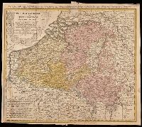
Belgium Catholicum seu decem provinciae Germaniae inferioris and Carte des Pais Bas catholiques où des X provinces de l'Allegmagne inférieure, etc. dessinée au juste selon les exactes observations astronomiques et opérations géometriques des Messur. Cass
Description:
"Avec privil. Imperial" above neat line., Includes 8 bar scales., Includes coats-of-arms of ten provinces., Relief shown pictorially., and Watermark. Manuscript number in upper right corner: 262[?]. From the Karpinski-von Wieser Map Collection.
Publisher:
Edentibus Homannianis heredib.,
Subject (Geographic):
Belgium--Maps--Early works to 1800. and Luxembourg--Maps--Early works to 1800.
Subject (Name):
Cassini, César-François, 1714-1784, Homann Erben (Firm), and Snellius, Willebrord, 1580-1626
[Atlas factice of 32 maps and 1 distance table, produced by the Homann Erben firm]
Image Count:
2
Alternative Title:
Belgium Catholicum seu decem provinciae Germaniae inferioris and Carte des Pais Bas catholiques ou des X provinces de l’Allegmagne inferieure, etc. dessinee au juste selon les exactes observations astronomiques et operations geometriques des Messur. Cassini, Snellius, Muschenbrok, etc. dressee par Sr. Tobias Maier, mathematicien; aux depens des Heritiers de Homann
Subject (Geographic):
Belgium --Maps --Early works to 1800 and Luxembourg --Maps --Early works to 1800
Tardieu, P. F. (Pierre François), 1757-1822, author
Call Number:
451 1770
Container / Volume:
BRBL_00258
Image Count:
1
Resource Type:
Maps, Atlases & Globes
Description:
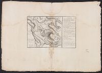
"A. Pl. 34.", Bar scales given in "Echelle de 600 Sagenes" and "Echelle de 600 Toises.", Coordinates not present on map and are approximated, From Nicolas-Gabriel Clerc's Histoire physique, morale, civile et politique de la Russie moderne., and Includes legend to
Subject (Geographic):
Bender (Moldova)--Maps--Early works to 1800
Subject (Name):
Clerc, Nicolas-Gabriel, 1726-1798. Histoire physique, morale, civile et politique de la Russie moderne
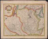
Camden, William, d 1551-1623. Britannia. English Churchill, Awnsham, -1728, publisher Churchill, John, active 1690-1714, publisher Morden, Robert, approximately 1650-1703, cartogra Nicholls, Sutton, engraver
Call Number:
3243 1690
Container / Volume:
BRBL_00066
Image Count:
1
Resource Type:
Maps, Atlases & Globes
Alternative Title:
Cambridgeshire
Description:
From William Camden's Britannia (first published 1695)., Gift of David Alan Richards, Yale BA 1967, 1972L., London meridia, Preliminary record., and Relief shown pictorially.
Subject (Geographic):
Cambridgeshire (England)--Adminstrative and political divisions--Maps--Early works to 1800 and Cambridgeshire (England)--Maps--Early works to 1800