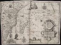
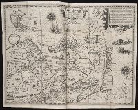
Nauigatio ac itinerarium Iohannis Hugonis Linscotani in Orientalem siue Lusitanorum Indiam
Image Count:
1
Description:
[Scale ca. 1:13,500,000]., Bound in following page 8., In pencil on bottom right panel of left verso: 8., In pencil on middle left panel of left verso: x., In pencil on middle right panel of left verso: 7-1., and Map has several tears along folds now repaired on verso.
Subject (Geographic):
Africa --Maps --Early works to 1800, Africa, East --Maps, and Madagascar --Maps --Early works to 1800
Subject (Name):
Claesz, Cornelis, ca. 1546-1609, publisher, Elzevier, Gillis, bookseller, and Hendricksz, Aelbrecht, fl. 1573-1605, printer
Subject (Topic):
Voyages and travels --Early works to 1800
Collection Created:
Hagae-Comitis : Ex officina Alberti Henrici, impensis authoris & Cornelii Nicolai, prostantque apud Aegidium Elseuirum, anno 1599
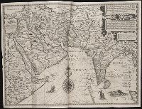
Nauigatio ac itinerarium Iohannis Hugonis Linscotani in Orientalem siue Lusitanorum Indiam
Image Count:
1
Description:
[Scale ca. 1:13,500,000]., Bound in following page 14., In pencil on middle left panel of left verso: 13-1., In pencil on middle left panel of right verso: 13., and Map has small tear along top center fold.
Subject (Geographic):
Afghanistan --Maps, Egypt --Maps --Early works to 1800, India --Maps, Iran --Maps --Early works to 1800, Iraq --Maps, Pakistan --Maps, and Saudi Arabia --Maps
Subject (Name):
Claesz, Cornelis, ca. 1546-1609, publisher, Elzevier, Gillis, bookseller, and Hendricksz, Aelbrecht, fl. 1573-1605, printer
Subject (Topic):
Voyages and travels --Early works to 1800
Collection Created:
Hagae-Comitis : Ex officina Alberti Henrici, impensis authoris & Cornelii Nicolai, prostantque apud Aegidium Elseuirum, anno 1599
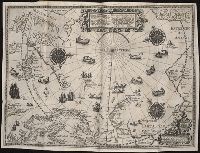
Barentsz, Willem, ca. 1550-1597. Deliniatio cartae trium navagationum Claesz, Cornelis, ca. 1546-1609 Duetecum, Baptista
Published / Created:
1598
Call Number:
Pequot +L65
Collection Title:
Nauigatio ac itinerarium Iohannis Hugonis Linscotani in Orientalem siue Lusitanorum Indiam
Image Count:
1
Description:
Bound in following page 16., In pencil on bottom left panel of right verso: 91 1 [upside down when unfolded; upright orientation when folded]., In pencil on middle right panel of left verso: 17-2., In pencil on top right panel of right verso: +., Map has several tears now repaired on verso., and Scale not given.
Subject (Geographic):
Arctic Ocean --Maps, Finland --Maps --Early works to 1800, Greenland --Maps --Early works to 1800, Iceland --Maps --Early works to 1800, Norway --Maps --Early works to 1800, and Sweden --Maps
Subject (Name):
Elzevier, Gillis, bookseller, Hendricksz, Aelbrecht, fl. 1573-1605, printer, and Langren, Arnold Florent van, 1580-1644
Subject (Topic):
Voyages and travels --Early works to 1800
Collection Created:
Hagae-Comitis : Ex officina Alberti Henrici, impensis authoris & Cornelii Nicolai, prostantque apud Aegidium Elseuirum, anno 1599
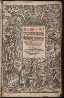
[Colophon: Gheprent Tantwerpen op die Camerpoort Brugghe, inden Schilt van Artoys : by my Hansken van Liesuelt, int jaer ons Heeren .M.CCCC. en. xxxviij. [1538] Den .xij. dach va Nouember]
Imperfect: t.p. mutilated with some loss of text; p. 83-86 of v. 1 wanting; slightly bled. Bookplate of John Watts De Peyster. and Signatures: [*]4A-D12E8F2 (C1-4 misbound after C6; C7-8 misbound after C9-12); A-H12I10.
Publisher:
Gedrukt by Bastiaen Wagens, boek-verkooper op't Steyger,
Subject (Name):
De Peyster, John Watts,--1821-1907--Bookplate
Subject (Topic):
Dutch language--Grammar, Dutch language--Terms and phrases, English language--Grammar, and English language--Terms and phrases
Nauigatio ac itinerarium Iohannis Hugonis Linscotani in Orientalem siue Lusitanorum Indiam
Image Count:
1
Description:
[Scale ca. 1:13,500,000]., Bound in following page 22., In pencil on middle left panel of left verso: 23., In pencil on middle right panel of left verso: 22-1., and Map has several areas of staining most noticeably along the top verso.
Subject (Geographic):
Borneo --Maps, China --Maps --Early works to 1800, Indonesia --Maps, Japan --Maps --Early works to 1800, Java (Indonesia) --Maps --Early works to 1800, and Philippines --Maps
Subject (Name):
Claesz, Cornelis, ca. 1546-1609, publisher, Elzevier, Gillis, bookseller, and Hendricksz, Aelbrecht, fl. 1573-1605, printer
Subject (Topic):
Voyages and travels --Early works to 1800
Collection Created:
Hagae-Comitis : Ex officina Alberti Henrici, impensis authoris & Cornelii Nicolai, prostantque apud Aegidium Elseuirum, anno 1599
Broeck, Crispin van den, 1524-ca. 1591 Visscher, Nicolaes, 1618-1679
Published / Created:
[ca. 1660]
Call Number:
1983 Folio 19
Collection Title:
[Atlas factice of 96 maps by Blaeu, Visscher, Jansson, Hondius and others]
Image Count:
2
Alternative Title:
Armenia Maior and Asia et Armenia Minor
Description:
Imperfect: illustrations at top cut-out and replaced with ms. titles "Asia et Armenia minor" (upper left) and "Armenia minor" (in upper right); torn along fold and at left edge, with some loss of text. Sheet measures 32 x 47.8 cm. Reinforced along edges with printed waste. No. 85 of 92 maps bound together. and Numbered 91 on verso.
Publisher:
[Nicolaes Visscher]
Subject (Geographic):
Armenia --Maps --Early works to 1800, Assyria --Maps, Egypt --Maps --Early works to 1800, Middle east --Maps --Early works to 1800, Palestine --Geography --Maps --Early works to 1800, Saudi Arabia --Maps, Syria --Maps, and Turkey --Maps