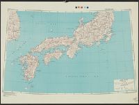
Japan special strategic map, south, Series (Standard map series designation system) ; 5207., and Series ; 5207
Description:
"Army Map Service, U.S. Army, Washington, D.C. 301605 ... 1943 ... 7-45.", Relief shown by hachures and spot heights., and Shows primary and secondary roads and two types of railroads.
National Geographic Society (U.S.). Cartographic Division
Published / Created:
1945
Call Number:
57 1945
Container / Volume:
BRBL_00303
Image Count:
1
Resource Type:
Maps, Atlases & Globes
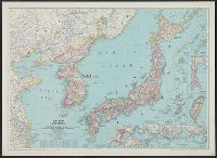
Description:
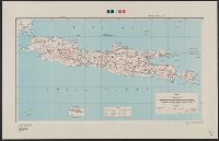
"Albers conical equal-area projection.", Copy 2 mounted on linen., Includes glossary of geographical terms., and Insets: 1-2. Kuril Islands.--3. Pescadores.--4. Karafuto.--5-7. Ryukyu Islands.--8. Formosa.--9. Tokyo.--10. Location of Japan in the Western Pacific
National Geographic Society (U.S.). Cartographic Division
Published / Created:
1945
Call Number:
57 1945
Container / Volume:
BRBL_00303
Image Count:
1
Resource Type:
Maps, Atlases & Globes
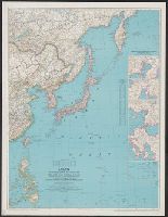
Description:
"Albers conical equal-area projection.", Includes glossary of g, Insets: 1-2. Kuril Islands.--3. Pescadores.--4. Karafuto.--5-7. Ryukyu Islands.--8. Formosa.--9. Tokyo.--10. Location of Japan in the Western Pacific., and Relief shown by shading and spot heights.
National Geographic Society (U.S.). Cartographic Division
Published / Created:
1944
Call Number:
556 1944A
Container / Volume:
BRBL_00293
Image Count:
1
Resource Type:
Maps, Atlases & Globes
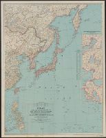
Description:
"Azimuthal equidistant projection centered on Tokyo.", Insets: Industrial centers of Japan (5 maps)--Marshall Islands., Issued with the National geographic magazine, v. 85, no. 4, Apr. 1944., and Relief shown by hachures and spot heights.
National Geographic Society (U.S.). Cartographic Division
Published / Created:
1944
Call Number:
57 1944A
Container / Volume:
BRBL_00303
Image Count:
1
Resource Type:
Maps, Atlases & Globes
Description:
"Azimuthal equidistant projection centered on Tokyo.", Insets: Industrial centers of Japan (5 maps)--Marshall Islands., Issued with the National geographic magazine, v. 85, no. 4, Apr. 1944., and Relief shown by hachures and spot heights.
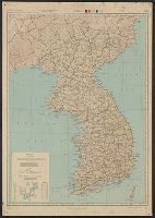
"141098.", "8-45.", "A.M.S. L302.", "Compiled from Korea Relief Map, 1:1,000,000, AAF, 1944 ...", "Type A-AMS 1.", Includes notes, glossary, "Conversion graph," and adjoining sheets index., Relief shown by shading and spot heights., and Standard map series designati
Its A.M.S. 9101 and Series (Standard map series designation system) ; 9101.
Description:
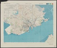
Elevations are shown by hachures and spot heights in meters., Inset shows area with detailed transportation information., and Three classes of roads and trails and four classes of railroads are shown.
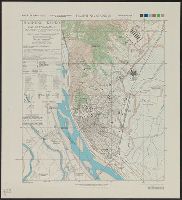
[Series] L951, Chinnamp'o (Chinnampo) P'yongan-namdo (Heian-nando), Korea, and Chinnamp'o, Korea
Description:
"5-45.", "AMS L951.", "Contour interval 10 meters ... Heights in meters, depths in fathoms at nearly lowest low water.", and "Korean names transcribed according to the McCune-Reischauer system: Japanese forms of Korean names (in parenthesis) transcribed accordin
[Series] L951, Hamhung (Kanko) Hamgyong-namdo (Kankyo-nando), Korea, and Hamhung (Kanko) Korea
Description:
"6-45.", "AMS L951.", "Contour interval 5 meters.", "Korean names transcribed according to the McCune-Reischauer system; Japanese forms of Korean names (in parentheses) transcribed according to the modified Hepburn (Romaji) system.", and Includes glossary to Kore